brooklynwx99
-
Posts
5,640 -
Joined
-
Last visited
2 Followers

About brooklynwx99

- Birthday 06/18/1999
Recent Profile Visitors
43,159 profile views


-

2025-2026 ENSO
brooklynwx99 replied to 40/70 Benchmark's topic in Weather Forecasting and Discussion
wouldn't be surprising if we had another -EPO dominant winter with intervals of blocking. still some -PNA, obviously. likely AN temps in the mean, but we'll probably have some colder intervals with blocking... overall, doesn't seem like too much of a deviation from last winter's vibe, which I would run back and see if the dice can roll a bit better -
2025-2026 ENSO
brooklynwx99 replied to 40/70 Benchmark's topic in Weather Forecasting and Discussion
there was a span of time where pretty much every KU pattern hit from like 2016 through 2021, and people got spoiled and thought that would continue... I am one of those people and have tried to remove that bias. it just happened so often that it was easy to assume that kind of loaded WB -NAO pattern would give a 75-90% hit rate - in reality it's much lower -
2025-2026 ENSO
brooklynwx99 replied to 40/70 Benchmark's topic in Weather Forecasting and Discussion
CC is absolutely a factor, that is not a debate. snowfall is just so prone to variance and we came off of such a torrid stretch that I want to give it another 10 year span to make sure that this isn't just regression to the mean. it'll probably be 75% bust, 25% boom seasons from here on out with very little in the way of true average -
2025-2026 ENSO
brooklynwx99 replied to 40/70 Benchmark's topic in Weather Forecasting and Discussion
agreed, that was always the main issue with that setup and made it a lot more precarious. if it had a true +PNA, easy KU. one could attribute that to CC, but we were never going to see perfect +PNAs with every setup. I think a lot of it is regression to the mean i agree with you that if this is still happening in a decade, it's time to have a serious convo -
2025-2026 ENSO
brooklynwx99 replied to 40/70 Benchmark's topic in Weather Forecasting and Discussion
yeah, that did not help. what was interesting was I remember the PNA ridge trending "better" as the event moved up, but the ULL deteriorated to the point that it didn't matter. just kinda became messy because of weird ULL stuff. they're finicky, always have been -
2025-2026 ENSO
brooklynwx99 replied to 40/70 Benchmark's topic in Weather Forecasting and Discussion
I think part of it is that back in the 2000s and 2010s, most KU setups delivered (March 2018 is a great example), and now we're seeing some flies in the ointment. sure, some of those failure modes are popping up more and more because of CC, but I think we got a bit spoiled, so now a block pops up and everyone expects a KU (I am personally guilty of this and am trying to remove this bias) mid-Feb easily could have occurred, the ULL just became a bit sloppy and the system became more disorganized... it still delivered historic snow to VA beach, and there was also a once in a lifetime Gulf Coast storm -
2025-2026 ENSO
brooklynwx99 replied to 40/70 Benchmark's topic in Weather Forecasting and Discussion
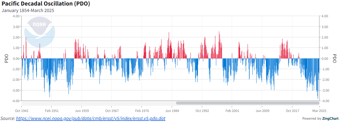
I don't think there's any legitimate way that the 2013-15 +PDO could be viewed as a "three year cycle" or whatever. there have been numerous instances of +PDO in -PDO cycles and vice versa since the 40s. it's nothing new. you can see the same thing in the late 50s, late 80s, and the mid-2000s. IMO it's just authors trying to rationalize typical variance as a broader consequence of climate change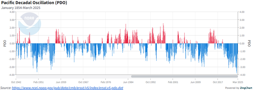
-
the Southeast and southern MA is loving climate change right now
-
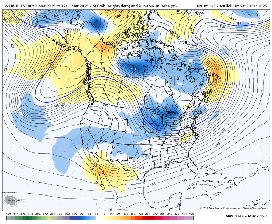
the heights over British Columbia are higher again
-
simple, the GFS is tallest with the ridge out west and allows the NS to have better momentum
-
the CMC and UKMET are also much better looking out west. I am definitely taking the GFS with a grain of salt but it's not that far off, and the PNA has been trending better for a while now
-
FWIW the CMC did make some nice shifts synoptically
-
the trend with the PNA over the last model cycle has been pretty nice. went from a trough to a full latitude ridge on the GEFS over BC
-
agreed, though the trend for more -NAO probably does limit the extent of the warmth
-
dude that was two weeks ago, damn