All Activity
- Past hour
-
Any brief mix here if it does will go back to snow as CF moves through and winds aloft still out of NE. You should do well even if you flip for a few hours. Much better look there vs outer cape
-
Only goes up to 66hrs
-
.thumb.jpg.6a4895b2a43f87359e4e7d04a6fa0d14.jpg)
Central PA Winter 25/26 Discussion and Obs
Yardstickgozinya replied to MAG5035's topic in Upstate New York/Pennsylvania
I guess it Bern but whatever you get the point. -

“Cory’s in LA! Let’s MECS!” Jan. 24-26 Disco
weatherwiz replied to TheSnowman's topic in New England
Given the airmass, the trend could actually be a significant benefit to us, at least on the mesoscale level when it comes time to pinning down banding and what the potential amounts may be -

Possible Record Breaking Cold + Snow Sunday 1/25 - Tuesday 1/27
NEG NAO replied to TriPol's topic in New York City Metro
Notice that Mt. Holly's Winter Storm Watches only include mixing in their southern zones WSW from KPHI -

January 24-26: Miracle or Mirage Thread 2
SomeguyfromTakomaPark replied to mappy's topic in Mid Atlantic
Jeez, these are gaudy. Is this an artifact of questionable precip algorithm or does it think that much snow for real? -
Do we have access to the 6z operational run?
-

1/24-1/25 Major Winter Storm - S. IL, IN, MI and OH
cyclone77 replied to A-L-E-K's topic in Lakes/Ohio Valley
-
They are always concerning even when you think you're far enough north or west. With that said if this ended with just the last .10 of precip as sleet, I find that ideal for many different reasons.
-

January 24-26: Miracle or Mirage JV/Banter Thread!
mappy replied to SnowenOutThere's topic in Mid Atlantic
lol I can be cool too -

January 24-26: Miracle or Mirage JV/Banter Thread!
nw baltimore wx replied to SnowenOutThere's topic in Mid Atlantic
A Viking seed? -

“Cory’s in LA! Let’s MECS!” Jan. 24-26 Disco
SouthCoastMA replied to TheSnowman's topic in New England
At worst 95% of your precip will be snow. I have a bit more to worry about after the initial thump. Euro still looks decent despite changing over. All bets are off if the trend to keep the primary stronger and further north persists -

Possible Record Breaking Cold + Snow Sunday 1/25 - Tuesday 1/27
Rjay replied to TriPol's topic in New York City Metro
No he didn't. He also knows what he's looking at. I have no idea why you guys are getting annoyed with him. -
I rarely post here despite being a long time lurker. But why exactly are our models so bad at this? We seem to have improved immensely with hurricane forecasting in the last 10-15 years, but modeling this type of event seems to have had zero long range progress. What's the inherent difference?
-

Central PA Winter 25/26 Discussion and Obs
Jns2183 replied to MAG5035's topic in Upstate New York/Pennsylvania
Look to bottom right at initial phase then look at skew-t. I'm utterly confused how initial phase is not snow Sent from my SM-S731U using Tapatalk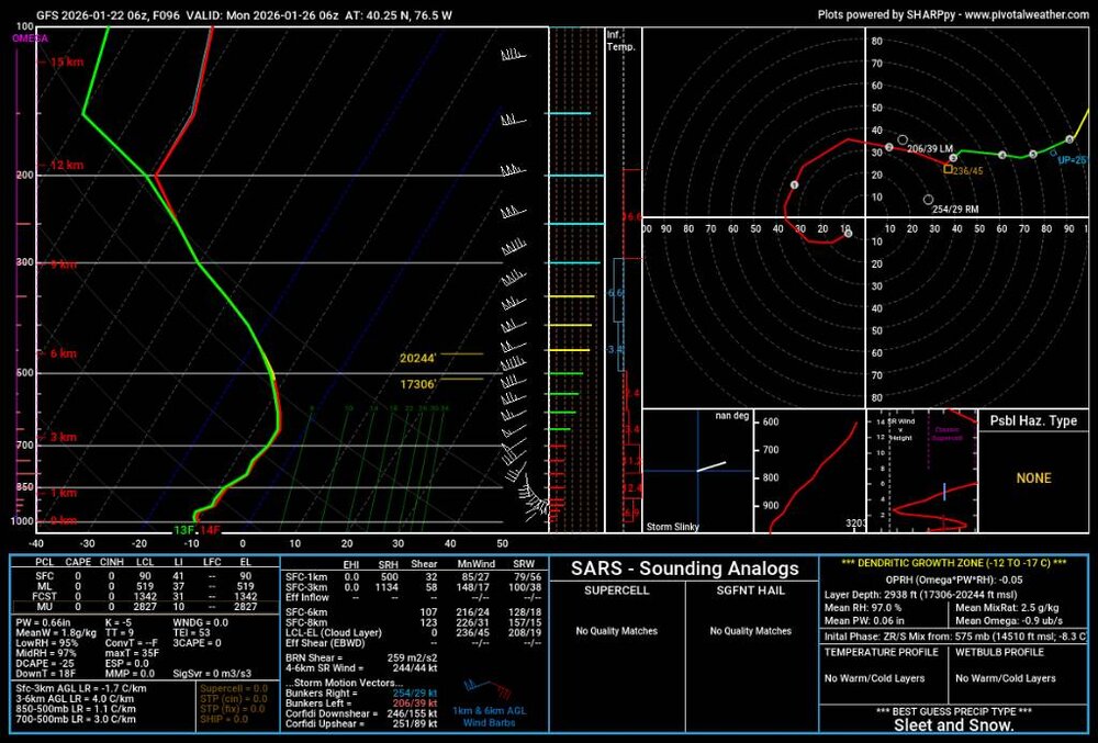
-

Let’s talk winter!! Ohio and surrounding states!! 24'-25'
pondo1000 replied to buckeye's topic in Lakes/Ohio Valley
Nice to finally have a big one to track here in central Ohio! Looking likely to have first Winter Storm Warning in years. My concern now is cold/dry air winning out & that precip shield getting shunted to the south. Not saying it won’t snow but big snow here still at risk. Ratios should be good but too cold & you get a pixy dust storm. -
No rest for the weary here. Hopefully everyone has power to track this next wave in the 10 day. All 3 major models show another shot. Of course take it with a grain of salt, but winter certainly doesn’t look over after the ice passes.
-
I felt terrible for him. It’s hard to read these mods and see our snow disappear, I can’t imagine being on here living in Halls watching it rain and reading about Maynardville having 8+ inches of snow. .
-

January 2026 regional war/obs/disco thread
Damage In Tolland replied to Baroclinic Zone's topic in New England
Euro -
6z Ukie ensembles convinced they were too warm.
(3).thumb.png.666765e80c43f5e02fba2f89afb4bbf8.png)
-
@Blacksburg Coachnight and day difference there between GFS and EURO. Those are FRAM averages too which is even more significant when we're talking about accrual/accretion.
-

January 24-26: Miracle or Mirage JV/Banter Thread!
aldie 22 replied to SnowenOutThere's topic in Mid Atlantic
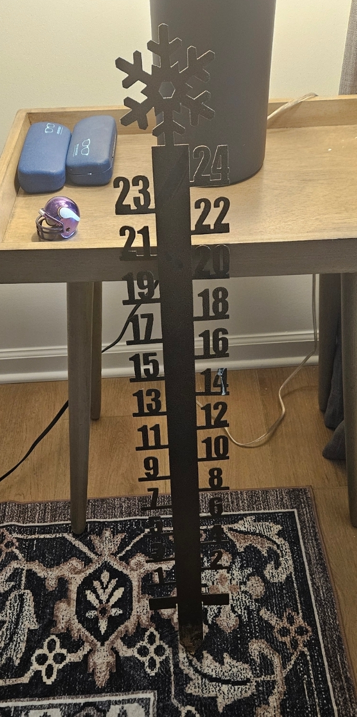
Time to go plant this bad boy in the yard
-
Central PA Winter 25/26 Discussion and Obs
Yardstickgozinya replied to MAG5035's topic in Upstate New York/Pennsylvania
Feel the Burn -

January 25-26 Winter Storm Potential
The Iceman replied to Ralph Wiggum's topic in Philadelphia Region
Extremely bullish briefing by mt holly. Wow. https://www.weather.gov/media/phi/current_briefing.pdf -

1/24-1/25 Major Winter Storm - S. IL, IN, MI and OH
Chicago WX replied to A-L-E-K's topic in Lakes/Ohio Valley
This piece of crap is supposed to replace the NAM at some point, I believe. But hey, dare to dream.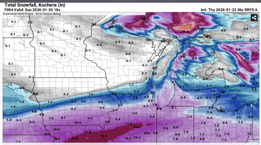


(3).png.fe2817e0b891ecc2e4da11456e9be627.png)