

Hvward
-
Posts
3,523 -
Joined
-
Last visited
About Hvward

Recent Profile Visitors
5,364 profile views


-
28 and white out conditions here at my house in Black Mountain.
-
Band is developing over Alabama. This is going to be some of the heavier snow we have seen in a while. I am looking forward to it. Got my calendar cleared.
-
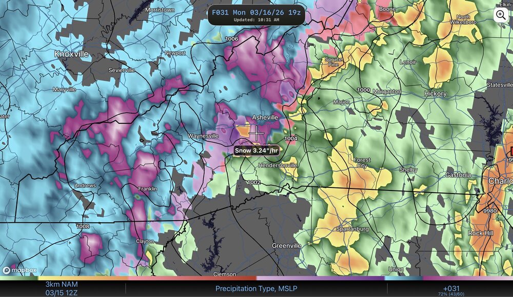
I am very intrigued with Monday. Nam3km showing rates of 2"+ per hour around 3-5pm in Buncombe County. Looks like the column of air goes frozen as the heavy precipitation moves in. Upper Level Low going negative tilt helps this. I'll be watching the Alabama radar tomorrow to see what is developing. That will be the main slug of moisture and then NWF. NAM3km gave man 3" on the 12Z run, looks to agree with the GFS. Euro still on board with a dusting for most. Also as Met mentioned, the long range pattern certainly doesn't look warm.
-
20 degrees here with heavy snow. Drinking a Coors light off draft with around half an inch and we are currently getting hammered with snow and Coors light! Hope everyone here is enjoying!
-
I see Transylvania Co schools are out today because of snowfall from this morning? Thats wild, looks like a small bit of moisture worked in at like 4-5am.
-
Bros were posting at the same time .
-
The Clipper system for Friday and Saturday looks pretty legit. Both GFS and Euro have North of I-40 getting accumulation. The NAM 3km went crazy. A more northern stream looks to favor my house with NWF. I do terrible in typical northwest flow, but when it ticks a bit more northerly the big flakes seem to flow in. Always one of the fun things about moving here in WNC is seeing how you do with different types of Northwest flow!
-
We have nearly half an inch at my house 27 with light snow currently.
-
Got snow falling at my house now. 18z NAM 3km give many 1”+!
-
Wednesday night starting to look interesting. Euro 18z has an inch for some. Why not?
-
The view out of my “snow watching” window is just amazing, this is such a beautiful snow. Closing in on 6” at my house. Also did a little shoveling but you can’t tell now haha.
-
First light on my porch.
-
Closing in on around 2” at my house and it is hammering.
-
Finally have a light snow at my house in Black Mountain.
-
Yeah I posted the final map a few posts down. Got excited when we got above 6" lol.


