

Ja643y
-
Posts
105 -
Joined
-
Last visited
About Ja643y

Recent Profile Visitors
2,454 profile views


-
Not sure what’s going on with my posts.. but yes, just started up near little Switzerland with tiny flakes and 1/4 to 1/2” on top of the glacier ice!
-
Hey all, sorry to ask again, but trying to decide if it is worth making the trip up. You all know the micro climates of the area better than the models. Thoughts on 4-6” for basically Parkway and 226? I’ve only been up there once and that was for Jan 2022. Not expecting that, but want to see your guys thoughts on my location for this one on the escarpment.
-
Any thoughts on escarpment for this one? I’m thinking of chasing, but have a long haul. I’d be Right above the parkway near 226. Looks like it starts to drop off pretty quickly around the escarpment… but still has potential for 6 plus?
-
Can someone with way more knowledge than me weigh in… the setup on 0z versus 18z looks better, but is it just faster? The neutral tilt at hr 69 looks much better to my untrained eye on the 0z, but maybe just too fast, thus late? Or could this be a surface depiction issue and that shield should be much further NW?
-
Cool one from the cam today. Sad I wasn’t able to get there for it.
-
Man do I wish I was up there. Looks like I may miss out on 6”+ in the Little Switzerland/Spruce Pine area if the short range models are correct!
-
Asked this in the other thread, but probably better suited here. Noticed that a lot of models have a sort of enhanced area of snowfall in Mitchell and McDowell counties, specifically closer to the SW corner of Mitchel near Spruce Pine. Any ideas why?
-
Can anyone explain to me the little maximum that’s been showing in a band through Mitchell and McDowell counties?
-
Pretty nice rates at App Ski mtn with decent size flakes!
-
2023-2024 Fall/Winter Mountain Thread
Ja643y replied to The Alchemist's topic in Southeastern States
Just like that back to mostly rain. Looks very rate dependent -
2023-2024 Fall/Winter Mountain Thread
Ja643y replied to The Alchemist's topic in Southeastern States
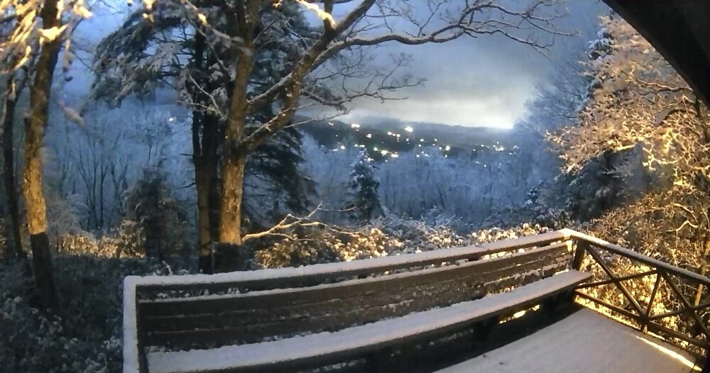
Just checked the camera for our place just above the BlueRidge off 226… snow finally starting come down a bit and stick on elevated parts of the deck. -
2023-2024 Fall/Winter Mountain Thread
Ja643y replied to The Alchemist's topic in Southeastern States
We left yesterday, but the outdoor cam I have shows more ice this morning than we had with the Saturday storm. All melted off now, but looked to be every bit of .25” this morning -
2023-2024 Fall/Winter Mountain Thread
Ja643y replied to The Alchemist's topic in Southeastern States
Just a very basic temp gauge that has been here for years, not sure how well calibrated… but showed 20 for morning low, 37 for high. Currently 30. -
2023-2024 Fall/Winter Mountain Thread
Ja643y replied to The Alchemist's topic in Southeastern States
I’m right up 226 from Marion before you get to Spruce Pine. Thoughts? Hoping to keep power tonight, but wouldn’t mind the kids waking up to an inch or two of snow. -
Yea, I'm just up 226 from Marion... It has not let up for nearly 2 hours. I'm from Florida, so know some good rainfall rates, and although I don't have a gauge here, would be we've picked up 2.5 to 3 inches just since 8a.

