All Activity
- Past hour
-
We are getting a solid cloud deck here in Knoxville for the first time today, and radar is closing up the hole around MRX's site.
-
Euro has been rock steady.
-

1/30-1/31 Lake Effect Snow Threat - SE WI, NE IL, and NW IN
cyclone77 replied to A-L-E-K's topic in Lakes/Ohio Valley
Radar shows the LE snow only a county east of here and moving west. Perhaps we get a taste? -

The “I bring the mojo” Jan 30-Feb 1 potential winter storm
franklin NCwx replied to lilj4425's topic in Southeastern States
It looks AI generated honestly. Alan always puts out great maps that are very detailed -

February 2026 Medium/ Long Range Discussion: Buckle Up!
Nomz replied to Weather Will's topic in Mid Atlantic
It is January 30th. DCA has close to 10 inches on the season. We have a full month+ of winter left. Remember that last week the first runs showing snow in our area were on Monday for what ended up being a Saturday night/Sunday morning event. -

Arctic Hounds Unleashed: Long Duration Late January Cold Snap
HoarfrostHubb replied to WxWatcher007's topic in New England
Was that 1943 temp legit? -

E PA/NJ/DE Winter 2025-26 Obs/Discussion
RedSky replied to LVblizzard's topic in Philadelphia Region
My coldest temperature despite this historic duration cold this week is an unimpressive 4F this morning Currently 13F -

The “I bring the mojo” Jan 30-Feb 1 potential winter storm
NorthHillsWx replied to lilj4425's topic in Southeastern States
And looks like they got a quick turnaround again this week -

1-30/2-1-26 Arctic Blast, ULL Snow Event
fountainguy97 replied to John1122's topic in Tennessee Valley
Radar really lighting up over Kingsport. Models had slowed the onset down toward 7-10pm. but this may be ahead of schedule. The models do have a lull this afternoon before the real forcing begins. -

February 2026 Medium/ Long Range Discussion: Buckle Up!
NorthArlington101 replied to Weather Will's topic in Mid Atlantic
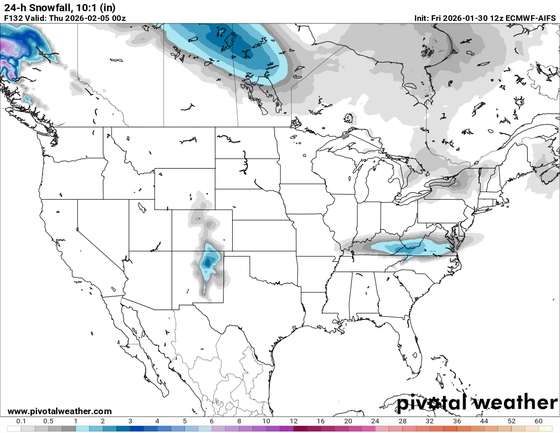
Only able to see precip total maps, but the non-AI euro has a northern band and a southern band kind of situation for Wednesday. Good chunk of Maryland squeaks out 1” or so - rest is too south for most of us. -

February 2026 Medium/ Long Range Discussion: Buckle Up!
mitchnick replied to Weather Will's topic in Mid Atlantic
I was looking at snowfall on Pivotal, not that it matters.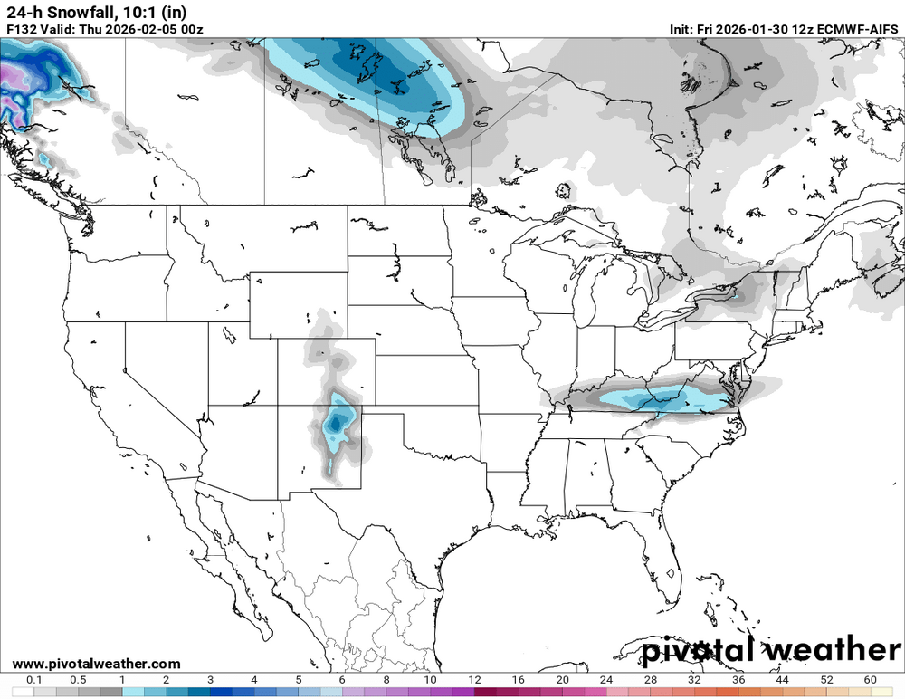
-
Got that strip through the SSE side of my county. Im like 5 miles to the N of it.
-

February 2026 Medium/ Long Range Discussion: Buckle Up!
Jersey Andrew replied to Weather Will's topic in Mid Atlantic
A lot of people in here thought February was setting up for a 2010 redux especially with long stretch of brutal cold. Will we really waste the month if PV suppresses everything to the south? -
Fuk these gulf systems, Lets get one to come thru the upper Tennessee valley and redevelop off the demarva.
-

Central PA Winter 25/26 Discussion and Obs
pasnownut replied to MAG5035's topic in Upstate New York/Pennsylvania
Have fun pal. -
icon is a good hit for VA weds/thurs.
-

The “I bring the mojo” Jan 30-Feb 1 potential winter storm
Derived42 replied to lilj4425's topic in Southeastern States
You know they're all exhausted. I remember seeing images from last weekend with air mattresses and makeshift sleeping quarters. -

February 2026 Medium/ Long Range Discussion: Buckle Up!
Steve25 replied to Weather Will's topic in Mid Atlantic
I’m with you for my area in specific, but I think we do need to keep in mind that this community isn’t just Central Maryland or northern areas. If I’m not mistaken, the Eastern Shore and Southern Maryland peeps got mostly left out of our last storm because they were too far south/east, and NOW they’re too far north/west for this coastal storm. So I really can’t blame those people for being very bitter at the moment. -
Do you mean the QBO will be west (+)? For the sub -20 December QBOs at 30 mb, what was the following Dec? 1965: -21; 1966: +13 1974: -23; 1975: +11 2005: -25; 2006: +6 2014: -25; 2015: +11 2021: -22; 2022: +12 2023: -23; 2024: +13 2025: -27; 2026: ? So, for all 7 Decembers with a sub -20 QBO, all of the subsequent Decembers were +6 to +13, which is intuitive based on the normal cycle. Thus, I see almost no way next winter will have anything near an east QBO. But, again, did you mean west (+) QBO? If you really meant E (-), on what are you basing that? Are you aware of the history that I’m posting here?
-
The “I bring the mojo” Jan 30-Feb 1 potential winter storm
NorthHillsWx replied to lilj4425's topic in Southeastern States
Being a met in NC the last 3 weeks probably the toughest job in America -
No it’s not, lol.. I work at a golf course. We have north, south, east and west facing greens and fairways that are out in the open sun. Still 16” deep. Only thing that has happened is some wind pack/scour and slight sublimation.
-
Feb 6-8 system growing legs. It's on all the big models GFS, CMC, Skynet. Next shot for a solid event.
-
E PA/NJ/DE Winter 2025-26 Obs/Discussion
RedSky replied to LVblizzard's topic in Philadelphia Region
How insanely cold is it? A west central Florida winter thread has been initiated for the SE region -

The “I bring the mojo” Jan 30-Feb 1 potential winter storm
ADB83 replied to lilj4425's topic in Southeastern States
I’ll take 5.6 inches in Greensboro and call it a day. NAM and UK are kind of on an island here. Seems like some of the mets are partial to the NAM solution and then others to the rest of them . -
Currently 8" snow depth not too far from Morristown, NJ. That's probably slightly above the 30 year average for the date but not unusual. There has been good snow cover for several weeks but not a deep snow pack. Lake ice is getting really thick.