All Activity
- Past hour
-
Ever since they canceled the festival, I haven't seen many either.
-
Absolutely a good year! Here is a video clip:
-
Got some miles in last night in Montreat. Great sunset. Prefect weather last night. .
-
Thinking of doing the wintertime Cog Railway trip up to 4000 feet in late November or early December. Anyone taken it before? Thanks.
-
Like the term squeegee line lol... also since when did NWS utilize Nadocast? Afternoon disco from LWX SHORT TERM /6 AM SUNDAY MORNING THROUGH MONDAY NIGHT/... A potent trough of low pressure will move into the northern/eastern Great Lakes Sunday morning while it`s associated cold front pushes east from the Ohio River Valley. Meanwhile, high pressure will reside off the southeast U.S coast leading to increased southerly flow across the region. With the tightened pressure gradient between the departing high and incoming front/trough of low pressure expect a windy end to the weekend. Dry and windy conditions are expected for most of the day as moisture steadily increases across the region. Mid and high level clouds will spread west to east from the Alleghenies Sunday morning into Sunday afternoon. Some filter breaks of sun will be observed early east of the I-81 corridor with any rain activity likely holding off until after sunset. 06Z/12Z CAMS have slowed a bit from previous model solutions. As it stands now, shower activity looks to develop west of the Alleghenies/I-81 corridor late Sunday afternoon before spreading east toward the metros late Sunday evening into Sunday night. Most guidance illustrates a frontal passage within the 2z-8z/10pm-4am window for areas east of I-81 and toward the I-95 metros. This is the time of greatest moisture surge and perhaps some subtle instability as the trough axis takes on a negative tilt. CAPE values look to remain less than 300 j/kg with bulk effective shear values running between 40-50 kts+. Forcing will be strong especially along the front. This will allow for both strong background winds and a strong wind field aloft to mix down to surface with any convective elements that form along the front. 06z/12z guidance continues to develop a line of gusty moderate to heavy showers that push from west to east across the area late Sunday afternoon into Sunday night. A few thunderstorms cannot be ruled out as well, especially west of I-95 where slightly better instability noted. SPC has expanded it`s Day 2 Marginal Risk (Level 1 out of 5) to encompass the entire area Sunday afternoon. The main threat is damaging wind gusts although an isolated tornado cannot be ruled out given low level SRH 0-1km values around 100-200 m2/s2 and potential meso-low overhead. Both CSU, CIPS, and NSSL probabilities focus 5 to 15 percent probs for damaging winds as a squeegee line of gusty showers push through late Sunday afternoon into Sunday night. Nadocast has 2 percent probs over northern and central MD mainly covering the pre-dawn hours of Monday morning. Additional showers are possible through Monday morning behind the cold front as the negatively tilted upper-level trough passes through. This activity will likely be short-lived with dry air working back in as high pressure builds from the south Monday afternoon into Monday evening.
-

Mid to long range discussion- 2025
WinstonSalemArlington replied to wncsnow's topic in Southeastern States
Halloween Eve -
Classic nina precip field?
-
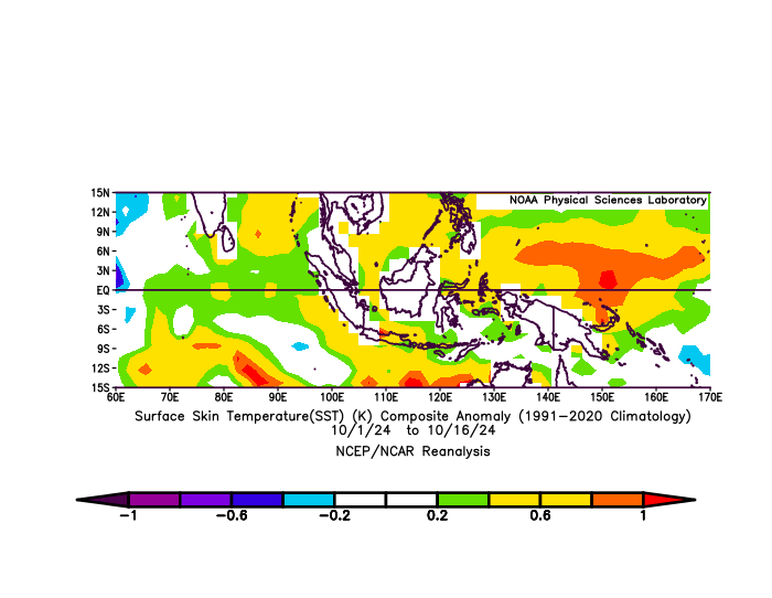
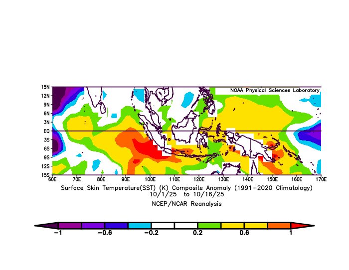
By which metric is the Pacific warm pool warmer than last year at this time? NOAA keeps a dataset on that area here : https://psl.noaa.gov/data/correlation/pacwarm.data 2024 0.592 0.659 0.500 0.591 0.604 0.605 0.655 0.635 0.640 0.654 0.658 0.492 2025 0.536 0.459 0.448 0.433 0.473 0.382 0.472 0.483 0.458 That data doesn't agree with the assertion... As per their defined area, here are last year versus this year for visual comparison. Last year: This year: The negative IOD certainly front and center in this part of the world, as has been discussed in this thread. No issue with that whatsoever. However, the tropical western pacific is actually not as warm as it was at this time last year. Neither are the waters in the vicinity of Indonesia. NOAA data reflects this year being less impressive as well. So by which metrics is this years west pacific much warmer than last year? I'm not seeing it and I disagree.
-
Straight up hot today. 82.
-

Spooky Season (October Disco Thread)
Torch Tiger replied to Prismshine Productions's topic in New England
^^ Had my car slightly underwater in that lot once when the Pemi went over banks. -

E PA/NJ/DE Autumn 2025 Obs/Discussion
Birds~69 replied to PhiEaglesfan712's topic in Philadelphia Region
I'm not one of those people. Screw it, get it while you can or you may get shut out... 68F / partly sunny -
Saw that one on the way to WOP this morning. Haven't seen many this year
-
Yeah I bet it was. The parkway is really showing off.
-
https://x.com/WeatherNut27/status/1979519862406893835?t=55aZXekPcWl4KPXZd3eBZA&s=19 Is it me or does NOAA always tend to have a warm bias on their winter forecasts?
- Today
-
Yes, it is early. Ryan Maue reposted Thierry Goose @ThierryGooseBC · 15h After Russia yesterday, Mongolia has just recorded its first -30°C of the season and this is exceptionally low for this time of year! -30.9°C Khatgal 3rd lowest October temperature since records began in 1963 (record: -33.0°C in 1976)! -30.2°C Tsetsen-Uul
-
Definitely lake effect or upslope behind a strong cold front if not synoptic
-
Definitely sliding past peak by now above the parkway over there and the color is spreading downward below it. 221 was fantastic.
-
Yeah the advertised late Oct- early Nov pattern looks like one that could snow in the western highlands.
-
Blocking and a big PNA spike open the window to some sort of strong slow moving system just before Halloween.
-
Obviously there are more drivers than ENSO and it does get too much attention at times. He is correct about the strong -IOD, ENSO and the West PAC warm pool being much stronger this year. IMO the real elephant in the room for this winter is the Category 5 “beyond extreme” marine heatwave ongoing off the coast of China that I posted about earlier today. I don’t think that is getting near enough attention
-
Siberian HP is strengthening, as it always does in Fall with decrease in sun angle and efficient radiational cooling in a hyper continental climate. Probably a bit earlier this year.
-
Yea wind was on and off after midnight so we didn’t drop much. Been the story lately
-
Don’t love the moist but I suppose we need it. Happy to ride the mild train as long as the Pacific keeps chugging along. .
-
If you look at the last 6 weeks of SSTA's at the link below, Enso 3.4 this year has averaged -.3C while last year's same 6 weeks come out to -.416C. It's a little cooler this year, sure. But I'd be a little more cautious about attributing anything to that difference at this point imho. Other portions of the equatorial Pacific over the period are similar in their differences for the most part too. https://www.cpc.ncep.noaa.gov/data/indices/wksst9120.for
-
Awesome pics as usual. The colors really started to pop the last couple of days.


