All Activity
- Past hour
-
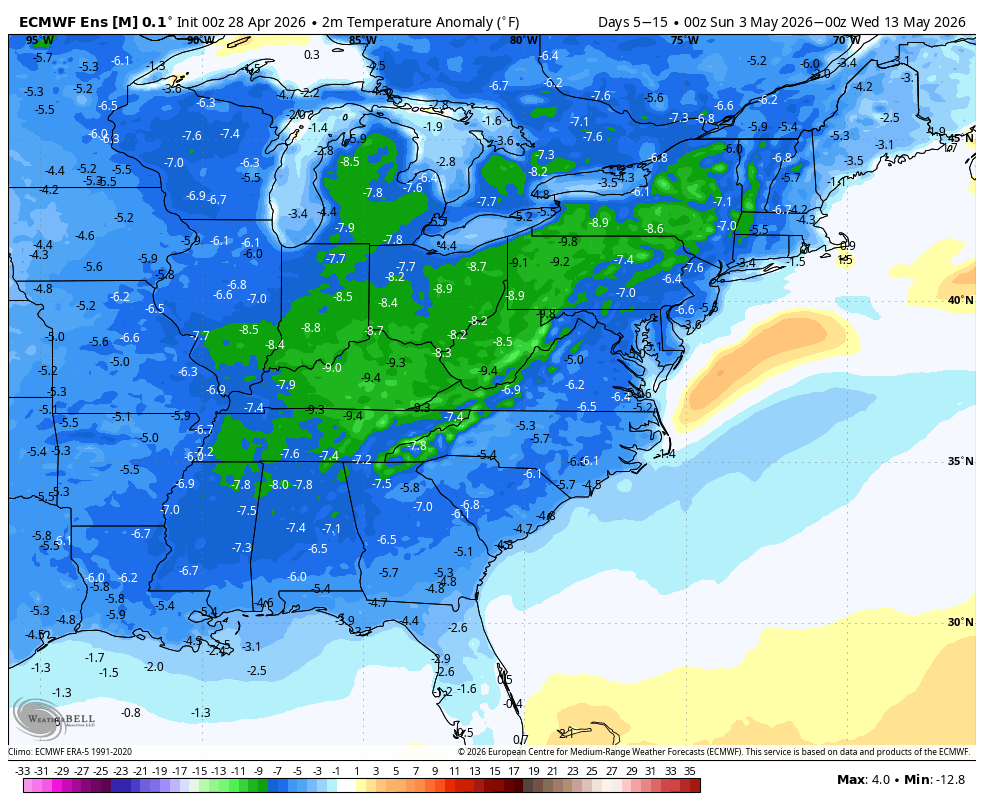
free of frost concerns here but a naso great mid range outlook
-
Looking ahead we are going to have frost potential as late as May 10th. I'd hold off planting a garden for a good 12+ days. Even if the frost is light/patchy the plants probably wouldn't grow much anyway with these cooler temps.
-
Oh my god, Ditty, look at that PDS watch, it is sooo big
-

2026 Mid-Atlantic Severe Storm General Discussion
Eskimo Joe replied to Kmlwx's topic in Mid Atlantic
That event was the biggest tornado outbreak that I can remember. The only other event that even comes close in my mind was April 16-17, 2011. Both events even spun tornadoes up into our area. -
Glad we didn't install.
-
I like big busts and I cannot lie?
-
Second big bust this year
-
0.38" at 7 am CoCoRaHS reading! Most since 4/2 when 0.51 fell. Brings monthly up to 1.41", still over 2" below normal. Currently 48.8/47.6 at 8 am with very light rain falling.
-
I was initially shocked to see the PDS tornado watch, especially given it was south of where the best overlap of ingredients seemed to be and even south of the moderate risk which was for the higher tornado probs. I wonder if the lack of upper-level forcing was a big culprit in this...those situations are always a challenge because too much forcing (or too strong) and you'll have convection developing all over the place making it difficult for convection to become mature enough and utilize the environment fully. Probably should throw in capping too...that EML may have been a bit too strong (coincident with the weaker forcing). This may have been a huge issue even in Missouri...many of those cells were really trying to take off but something was impeding those updrafts from really taking off.
-
WB 0Z EPS keeps it cool through mid May. Next long range rain chance toward the end of next week.

-
WB 0Z EPS keeps Saturday system to the south.

-
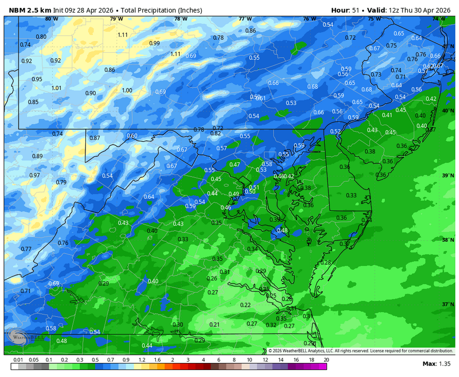
WB 9Z NBM for Wed.
-
I know the guy from Scituate showed those trees, but leaf out processing nicely here. Need to mow.
-
Wow, nice rain events within days of each other, feel like we won the lottery
-
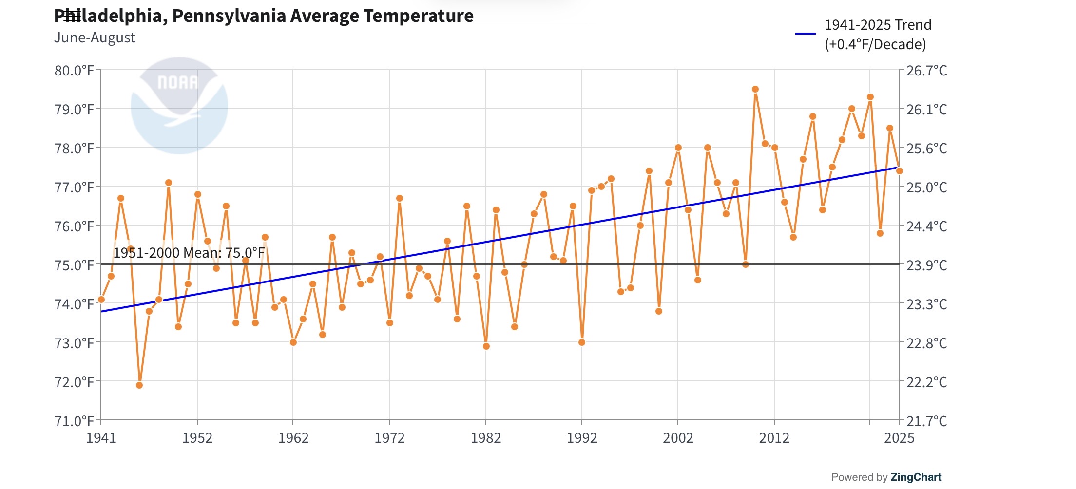
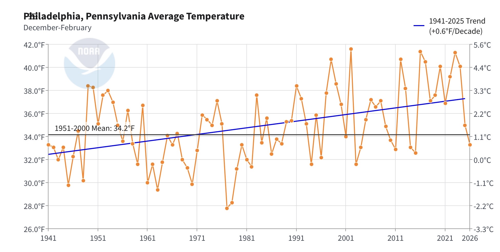
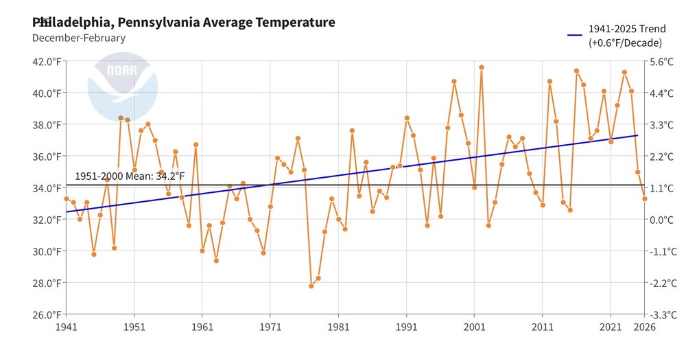
2009 was the last average temperature summer in Philly against the 1951-2000 mean. This was the first slightly cooler winter in Philly since 2015-2016. So it’s pretty representative of the wider trends across the region and nation.
-
Wow impressive #5!
-
The map I posted above updated- I guess its linked. It looks less impressive for tomorrow than when I posted it.
-
Back from Sanibel. Meh to mass lol. Went to Fort Myers beach before our flight home last evening to kill time. They are definitely slower to recover vs Sanibel. There were a lot of lots that you could tell were wiped clean and not rebuilt. A few dilapidated structures still remaining as well. Sad to see on such a nice beach. Real estate is still really high priced as well which surprised me. I thought it would be a little cheaper, but I guess not.
-
lol at the LIV golf debacle, love to see it. Reports are they are now postponing a tournament in Louisiana in June.
-
https://phys.org/news/2026-04-unprecedented-antarctic-dead-winter-decades.html (https://www.nature.com/articles/s41612-026-01392-x)
- Today
-
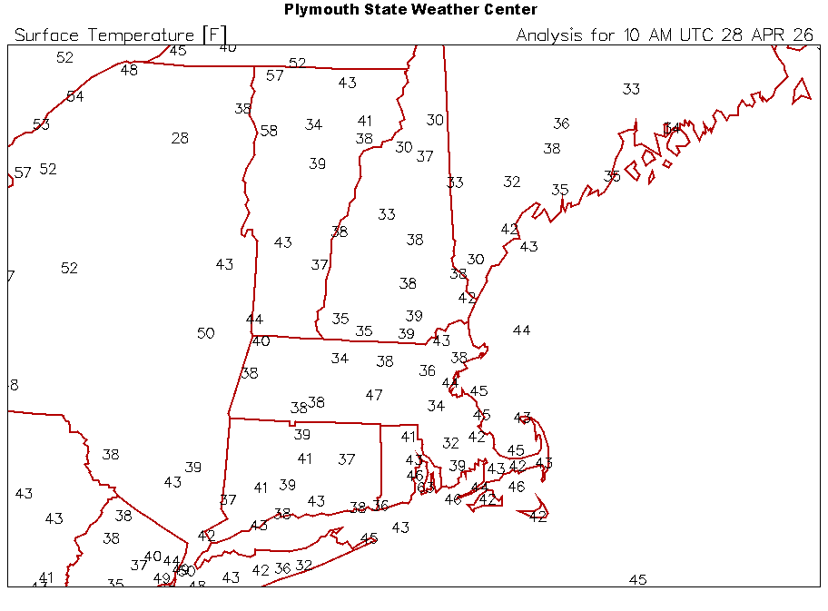
30.9 at KFOK and 45 here in Lynbrook. Same island extreme differences in radiational cooling. .
-
Interesting.... morning day 2 from SPC ..Allegheny Plateau into Mid Atlantic... Given the spread among the latest model output concerning the initial surface frontal low migrating through the Ohio Valley, and the developing surface troughing/warm front to the east of the Blue Ridge, substantial uncertainty remains concerning the convective potential for this period. Remnant convective cloud cover and rain overspreading the region early in the day may also impede destabilization. However, with at least weak to moderate boundary-layer destabilization, strengthening wind fields and forcing for ascent associated with an approaching mid-level jet could become conducive to organized severe storm development. This may initiate west of the Allegheny Mountains, and include potential for evolving supercell structures, before developing to the east of the Blue Ridge by late Wednesday afternoon into evening.
-
Min 37.8F lol at BTV this morning
-
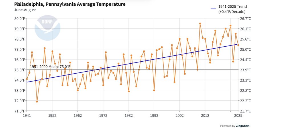
PHL Summers since 2010 Below 1981-2010 average (75.9) 2014 (75.7) 2023 (75.8, although JAS averaged 76.1, which is above the 1981-2010 average) Above 1981-2010 average, but below 1991-2020 average (76.7) 2013 (76.6) 2017 (76.4) Currently, the 2001-present average is 77.2, which would put 2018 (76.9) below it. Depending on how warm the summers of 2026-2030 are, last summer (77.4) could end up below the 2001-2030 average.
-
Lots of wrecks also this morning.