All Activity
- Past hour
-
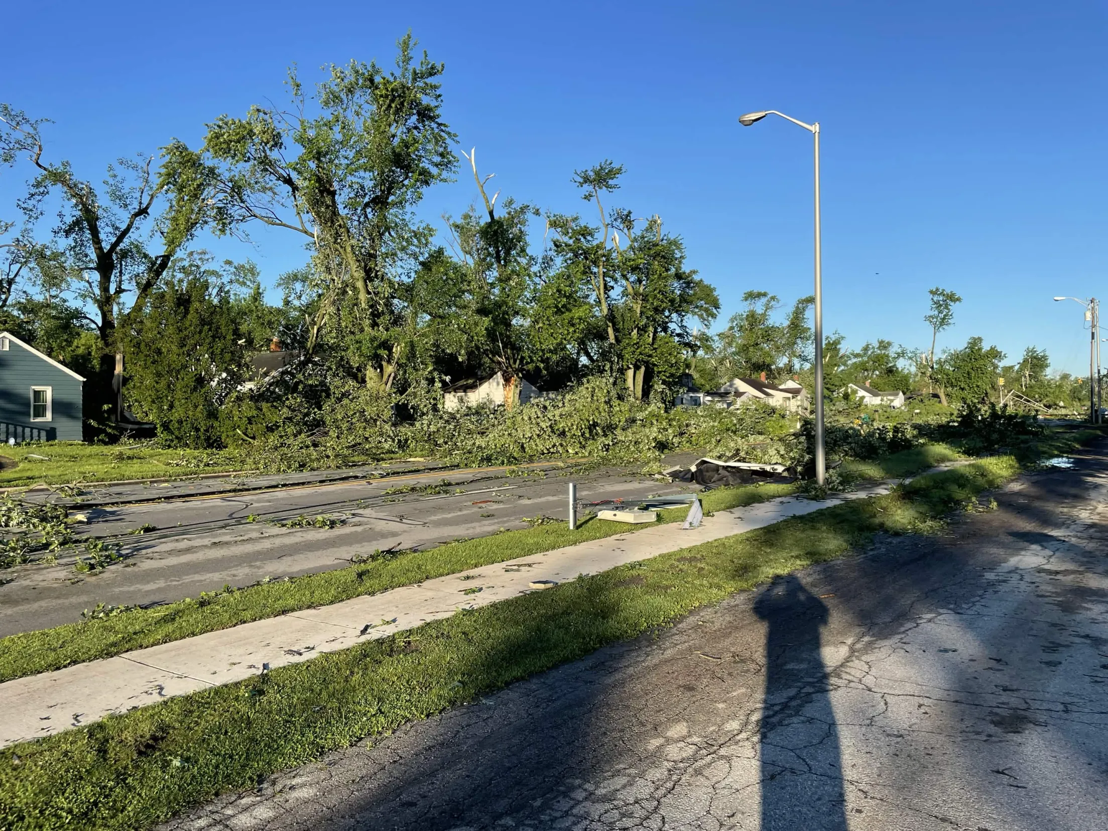
Was a mild storm at home...some twigs and leaves down; but drove to work this morning (3 miles east) and there's a fair number of small branches down. Live poplar mostly.
-

E PA/NJ/DE Summer 2026 Obs/Discussion
JTA66 replied to PhiEaglesfan712's topic in Philadelphia Region
Another overnight car-topper...er, 0.05" in the bucket. 78F/DP 71F -
Tonight looks dry
-

2026-2027 Super El Nino
snowman19 replied to Stormchaserchuck1's topic in Weather Forecasting and Discussion
-
Should this ceiling contamination go on much longer we're looking at a significant temperature bust today - I'm sure Ineedacoldbullshitfilterlikeanalcoholicneedsaclinic will stamp a 100% emoji on this ... but CT also just cleared out rather abruptly over the last hour. Interesting, considering they were wet down there last evening - but this material is mid level so probably not related to that same murk. Either way, temperature can't really rise unless the clearing down there expands. We'll see. We'll rise fast if that happens, but already we're behind yesterday despite the higher launch pad.
-
1” here in lynbrook most of which fell in 20 minutes with a wet microburst. Visibility was down to a few hundred feet during the peak. .
-
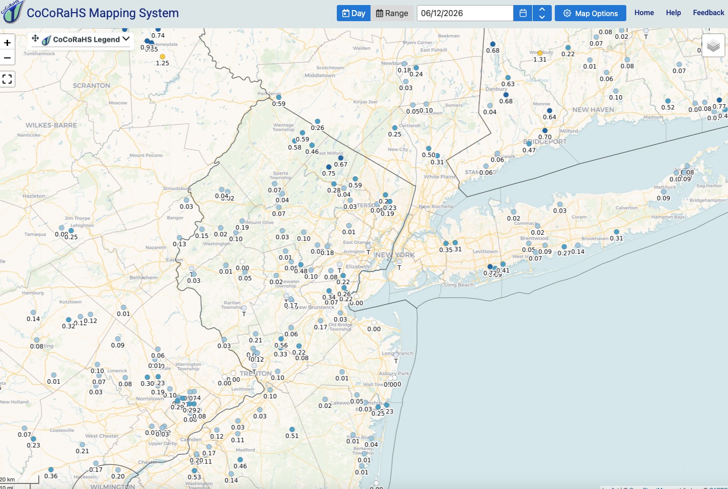
Hi imby/Columbia on Thursday a “normal” 98.6° Thursday rainfall 0.21” June rainfall 0.77”
-
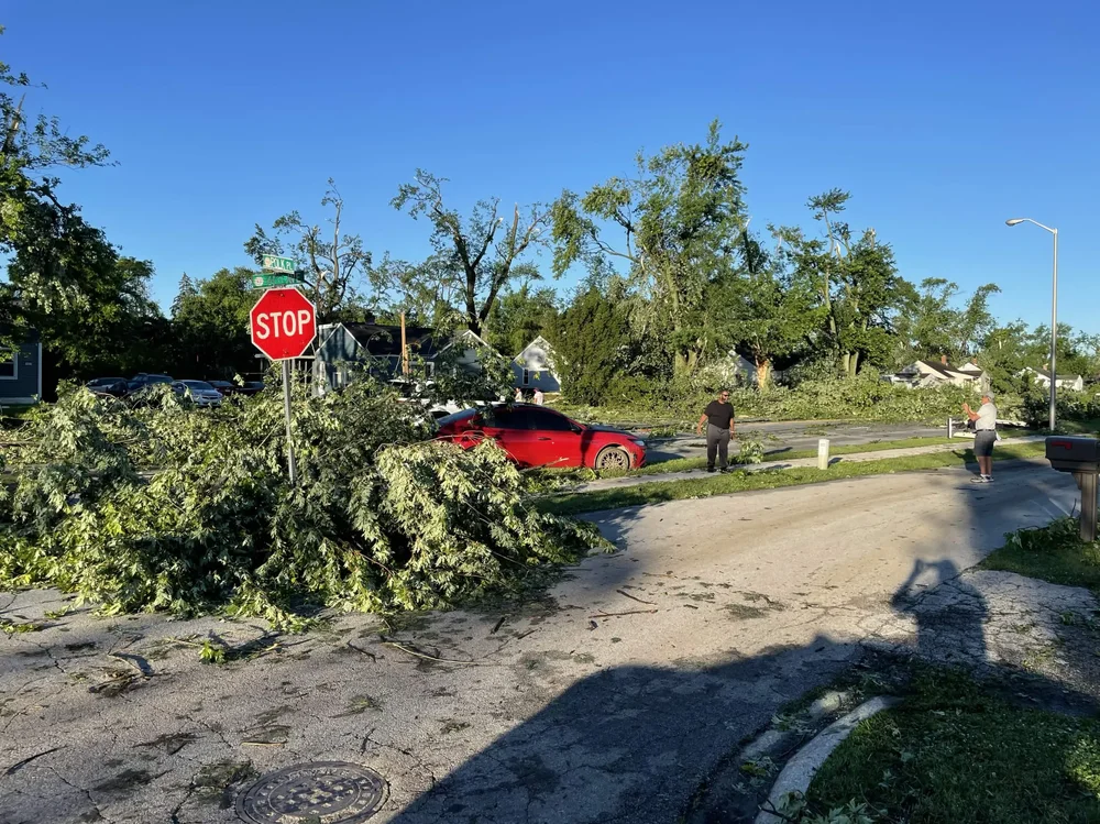
ff 61st Ave and Polk Pl. in Merrillville, IN, taken from my yard.

-
I hope you have backup plans to sit at Obrycki's
-
Sunday timing is not great for me with a 5pm flight
-

2026 Mid-Atlantic Severe Storm General Discussion
MillvilleWx replied to Kmlwx's topic in Mid Atlantic
Saw this way too late, but got some excellent responses below. Nothing to add to what has already be hashed out. Environmental conditions thermodynamically were solid for the setup, but we were lacking in shear within the mid and upper levels to sustain prominent mesocyclones to really pack the punch needed. I was skeptical of the risk posed by SPC yesterday. I genuinely think they need to spend a year out here to experience how much we suck at severe so they can think twice. After living in West Texas for 5 years, there's not much that excites me here anymore, severe-wise. If I am excited, you should be too as my standards have been raised after being spoiled for years in the Southern High Plains.- 586 replies
-
- 1
-

-
- severe
- thunderstorms
- (and 7 more)
-
.18 inch of much needed rain here last night.
-
Yep
-
2026 Mid-Atlantic Severe Storm General Discussion
MillvilleWx replied to Kmlwx's topic in Mid Atlantic
I freaking laugh snorted at this this morning -
Woah… just looked past this weekend. Who turned off summer?
-
(This worked last time) Wait, people are getting rain?
-

2026 Mid-Atlantic Severe Storm General Discussion
high risk replied to Kmlwx's topic in Mid Atlantic
Despite the 30 wind probs, there is very little CAM signal for storms for most of us today. Seems like a pre-frontal trough rolls through early and switches the low-level flow to west-northwest which dries things out and kills convergence. I’m not quite ready to write off the day yet, but I’d like to see an improved CAM signal in the morning runs.- 586 replies
-
- 1
-
-
- severe
- thunderstorms
- (and 7 more)
-
If we lose today at least Sunday is looking better as far as timing. Late afternoon instead of late evening.
-
Working his magic last night and this morning
-

Central PA Summer 2026 Discussion/Obs Thread
mahantango#1 replied to Voyager's topic in Upstate New York/Pennsylvania
Looks like most places won't see any rain today. -
Missed out on any decent rainfall last night. Just .07". Additional rain chances over the next few days. Will be localized and some locations will do better than others but some heavy downpours possible in spots for sure. Another steamy day today.

-

Junorch obs and discussion 2026
Damage In Tolland replied to Damage In Tolland's topic in New England
I’m talking about this afternoon. So you got a lucky stray shower . Congrats -
HRRR only has a few storms south of DC, but it aggressively mixes out the dew points too which probably is messing with things.
- Today
-
2026-2027 Super El Nino
snowman19 replied to Stormchaserchuck1's topic in Weather Forecasting and Discussion
-
i have one of those, the 12k version. amazing how quiet (and efficient) it is wrong already. about to get a decent downpour here at MHT, which saw nothing yesterday.