All Activity
- Past hour
-
 I honestly can’t recall the last time I called that body of water anything other than “the Gulf”.
 -

Central PA Summer 2026 Discussion/Obs Thread
canderson replied to Voyager's topic in Upstate New York/Pennsylvania
I mean being on water is a riskier space buuuuut cmon lol -
2026 Mid-Atlantic Severe Storm General Discussion
Roger Ramjet replied to Kmlwx's topic in Mid Atlantic
EF2 raked my subdivision in Remington. Lost 6 homes in my subdivision, including my next door neighbor's house. I lost one shudder - go figure. -
I work overnight (Sunday to Wednesday) so I have time to post lol Disco says we should get some breaks soon as the WF goes by... we shall see as you said
-
-

Central PA Summer 2026 Discussion/Obs Thread
pawatch replied to Voyager's topic in Upstate New York/Pennsylvania
66 degrees for the low. Fishing got canceled this morning because of the threat of severe weather. It was supposed to be rain showers this morning. But the sun is shining heating things up. -
i have a 6500 watt portable generator that I plug into an outlet outside the house which goes to a transfer switch. it is super easy, and powers everything I need, heat, water (on a well), and most importantly internet. i could use microwave but don't because it is obviously a huge power suck, and can't use the stove/oven.
-
If you lose power that much then a standalone is worth it. PG’s are good for basic needs (fridge, ac, heat, oven, etc) as long as you have the wiring installed by a pro. There is alot of good ones on the market at a fraction of the cost of standalones. It just depends how much power you need. https://www.popularmechanics.com/technology/infrastructure/a64917889/how-to-connect-a-generator-to-your-house/?utm_source=google&utm_medium=cpc&utm_campaign=mgu_ga_pop_m_bm_prog_org_us_a64917889&gad_source=1&gad_campaignid=23528319530&gbraid=0AAAAADCyiSlllkc8D1E59aDuuyYUORV7j&gclid=CjwKCAjwsfzSBhB5EiwAOGyqSSHSQy-bRh7GGYXtx3pUUINzlpjhy5SGDB0gRV2YQbxGfKzTwrmyXBoCF4EQAvD_BwE
-
Light drizzle north of Winchester
-
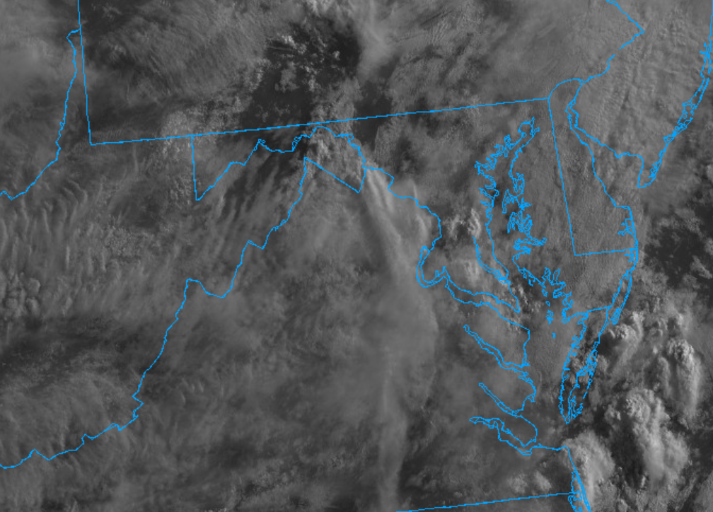
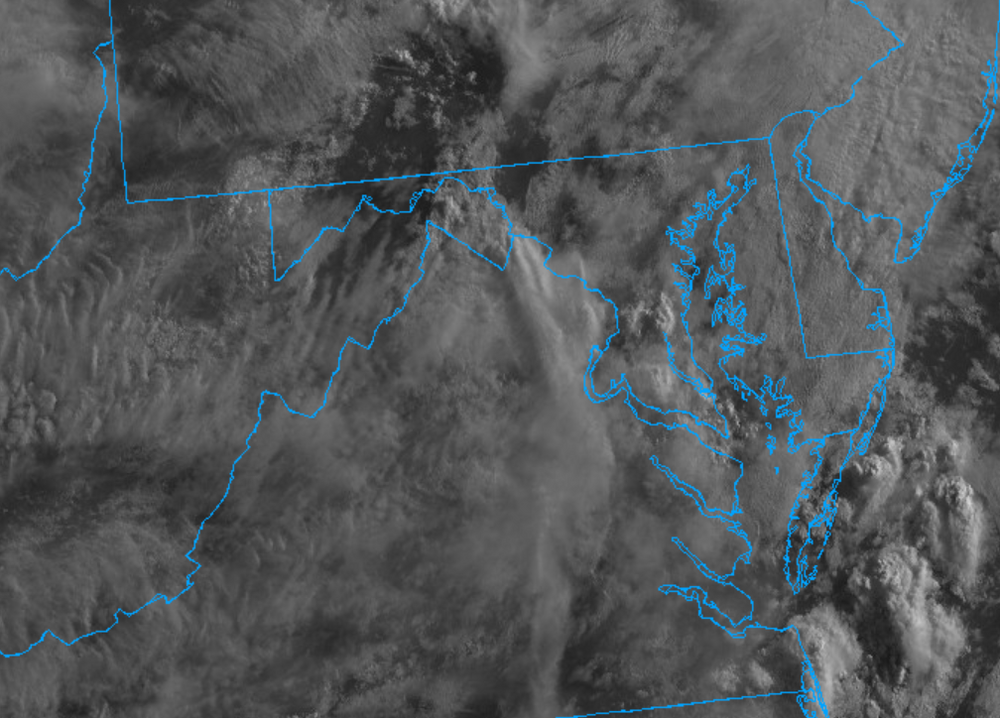
Our severe crew isn't always up super early (except @yoda who seems to never sleep lol). We don't do the wall-to-wall posting as well as the larger winter crowd. I'd expect by 9-10am you'll get some more of the folks posting in here. Pretty cloud in Colesville, MD right now. Haven't looked at visible sat yet though
-
 Man, this would be a cruel joke. Temps come down enough for tomatoes to ripen, and 3 inches of rain comes along to split them all.
 -
 First week of Augdewst signs of heat and humidity building in for extended time
 -

2026-2027 Super El Nino
bluewave replied to Stormchaserchuck1's topic in Weather Forecasting and Discussion
2023-2024 wasn’t even close in your area or mine from the seasonal models. What difference does it matter if they are warm or too cold? An incorrect forecast is an incorrect forecast if you are interested in trying to figure out your sensible weather. I understand some posters like yourself enjoy posing forecasts that they would personally like to see. Nothing wrong with that. But wouldn’t you like to actually post a model run that has a chance of being correct rather than what you want it to show? I mostly post longer range ENSO plumes forecasts and general SST forecasts from the seasonal models where they can sometimes have more skill. If I post a temperature or 500 mb forecast, it’s mostly to see where the model might be or has made an error in the past. I also see several posters mention that they are only interested in their own backyard or local area. That’s OK also. But if you want to understand how to find the potential range of outcomes you need to have a broader understanding of how your area is related to the greater patterns in the region, continent, and planet. It just so happens that as the world warms, the weather records count is more heavily skewed toward warmth than cold. So the models just have more opportunities to be wrong about the magnitude of the warmth. And yes they do miss the cold from time to time also. But since cold is less frequent these days, the opportunities are less. In my region we have had over 50 top 10 warmest months since 2010 and only one top 10 coldest. Many most of those top ten warmest months weren’t forecast by the longer range climate models. The one top 10 coldest month during February 2015 wasn’t forecast either. We posted many of the incorrect model forecasts at the time of how the long range weeklies missed the pattern change to colder in February. I remember there were literally dozens of posts about how the weeklies missed the record cold in February from the long range. I can guarantee you that I we had a climate getting colder rather than warmer, I would post maps of the models missing the cold long range. There would probably be some posters that would say why I am I so focused on the models missing the cold and I only am interested in the cold. -
Morning discussion from LWX on the threat today DISCUSSION... KEY MESSAGE 1...Strong to severe thunderstorms are likely today, with some thunderstorm risk lingering into Wednesday. Higher dew points have been advecting into the area with moisture and instability increasing in S/SW flow. So far shower activity has been isolated and short lived. However, a subtle shortwave is approaching, and some of the convection currently across WV and SW VA could persist or redevelop across the area through the early morning hours. Areas of stratus are also forming. Both of these features could inhibit surface heating this morning, although it does appear we should have some partial sun by midday as the warm front continues to lift to the north. This should be enough to allow temperatures to rise into the mid 80s to lower 90s. Combined with dew points in the 70s, at least moderate surface based instability should develop, highest east of the Blue Ridge Mountains. A seasonably strong trough will be approaching from the west, providing forcing and anywhere between 30 and 50 kt of flow in the cloud bearing layer. This will provide a favorable environment for severe thunderstorms, with supercells and clusters both possible. One initiation region will likely be along the prefrontal/lee trough near or just east of the Blue Ridge. These storms will likely affect the I-95 corridor between mid afternoon and early evening. While these storms will certainly carry severe potential, it is interesting to note on average the 850-700 mb wind fields will be greater to our south and west until late afternoon or early evening. Other details remain unresolved, especially the effects of upstream convection that moved through the upper Great Lakes and mid Mississippi Valley. This could have some impact on how thunderstorms develop across the Ohio Valley this afternoon and what subsequently moves into western areas. If stronger/more widespread convection does not move in from the Ohio Valley, there is some potential there is a relative minimum in coverage between the Blue Ridge and Alleghenies. The coverage of afternoon storms and upstream effects will determine what happens this evening as the strongest forcing overspread the area along with increasing low level wind fields. A second round of showers and thunderstorms will be possible for some areas, though increasing low level stability may limit the severe weather threat. It appears the evening/overnight coverage could gradually shift to southern parts of the forecast area, or even mostly to our south, potentially focusing on outflow from earlier activity. Damaging winds will be the primary severe hazard, although large hail and a tornado or two are possible if supercells develop. Some localized swaths of more considerable wind damage are possible. Relatively speaking, the tornado threat is higher to the north (and north of the CWA) closer to the warm front and possibly closer to the Chesapeake Bay where low level winds could be backed. With that said, forecast hodographs vary quite a bit between models and also throughout time, so any relatively higher threat will depend on the mesoscale details. With precipitable water values increasing (over 2 inches east of the Blue Ridge), any storm mergers and training along mesoscale boundaries could result in localized flash flooding. Overall storm motions will be progressive though, so this threat appears too localized for a Flood Watch at the moment and will continue to be evaluated. Additional areas to monitor will be the Ohio Valley low level jet potentially leading to training (looks to be mostly west of the area), and the evening low level jet leading to backbuilding along any residual outflow/convergence feature (best QPF signal is currently mostly south of the forecast area).
-
 No big dews or heat waves in sight. What a fantastic summeh.
 -
wisconsin delivered some photogenic stuff huh
-
Just picked up 1.62". My garden said thanks.
-

2026-2027 Super El Nino
40/70 Benchmark replied to Stormchaserchuck1's topic in Weather Forecasting and Discussion
I think it's important to be mindful of both if you are genuinely interested in the weather and especially if you forecast. It's important to take CC into account in forecasts, so it helps to be in tune with the rate at which it continues to progress, regardless of whether the NE CONUS was in a pocket of colder air last season. It important to keep everything in context...that said, it was refreshing to confirm that CC is not prohibitive to good NE winters. -
 RRFS can eat it. I’m still pumping out my basement from its output last week.
 -
The futurecast is essentially useless at 36-48 hours. It's akin to a 120-hour NAM run (NAM ends at 84 hours, just so one has context for my analogy). Not surprisingly, last night's figures were dramatically lowered and are now in line with the guidance. https://pix11.com/news/local-news/projected-rainfall-totals-in-ny-nj-ahead-of-storms/
-
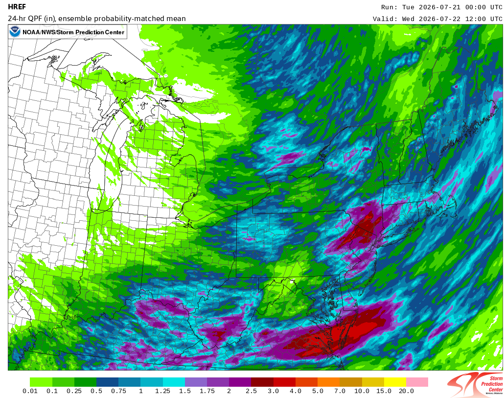
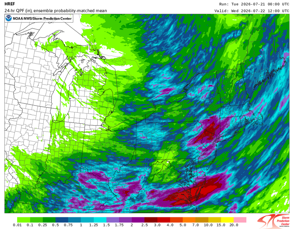
The overnight HREF:
-
that's awful, every 4-6 weeks? you and your neighbors must all be so pissed at the POCO. Is the issue mostly related to overhead wires and mature trees, or is it due to older under ground infrastructure?
-
Picked up an additional 0.12” overnight a some point which brings us up over 9” up to 9.02” MTD
-
 HRRR was a solid line moving through
 - Today
-
Back to "Bad Gateway" again when logging on.