All Activity
- Past hour
-
I'll tell ya ...having the sun now winning over the diminishing cloud coverage is helping to offset that rude intrusion of colder air. Ironically, it cloudier where the cold is deeper up N, and shittier sky where it's SW of this boundary. Weird to have it clear where the boundary itself, is It's 45 here... not "nice" per se, but relative to what it could be on March 10 that is nice. Not ungrateful. Plus, the wind behind this boundary isn't appreciably gusting and so forth, so there's some nape quality remaining. It does seem that the momentum of the front is slowed.
-
GFS got to get one more epic fail in before the end of the season.
-
Hrrr now takes the convection further north like the nam is showing
-

E PA/NJ/DE Spring 2026 Obs/Discussion
MJO812 replied to PhiEaglesfan712's topic in Philadelphia Region
.thumb.png.9f6ef61254366eb072aa2bb8c78e55e6.png)
-
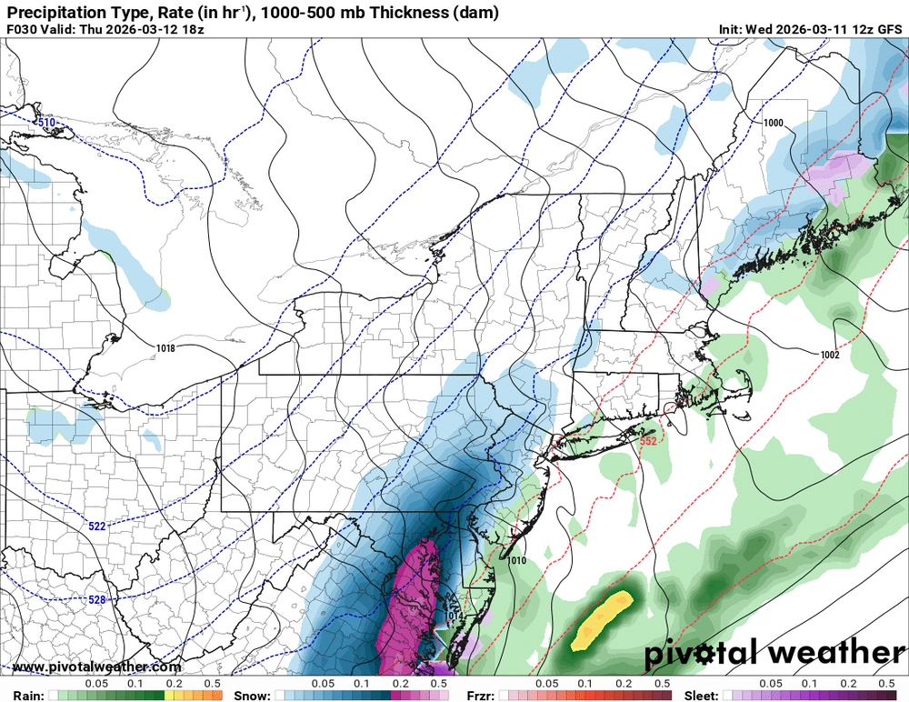
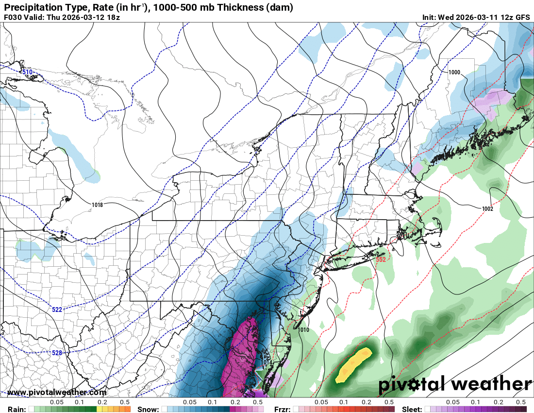
GFS!
-
NAM showing some love. Sent from my SM-G998U using Tapatalk
.thumb.jpg.5334c187395398fba9b412db08d7db27.jpg)
-
I need 1”. Hopefully tomorrow night
-
Yalls 24 hour temp change down east is going to be something else. Going to be a 40 to 50 degree temp drop.
-
Large “Hailbergs” from last night’s storm in Grand Rapids. https://www.facebook.com/share/p/1CMgnYijVc/?mibextid=wwXIfr Edit: Does anyone know how to embed links? A long time ago it used to be easy but the site has changed.
-
The stratus is moving onshore now. I’m sure there will be a secondary push of raw taint with that.
-
Models don’t show much action today.
-
Your lawn needed mowing in early March?
-
Absolutely textbook "horseshoe" base and monster RFD cut in that first image. I didn't give the potential for recovery enough credit, I assumed once the lake breeze boundary pushed through that would be sayonara for any supercell in the vicinity. Got on a cell just as it fired north of Galesburg and it looked briefly promising and went tornado-warned for a little while, but a whole bunch of updrafts went up all around and it quickly turned into a mess (potential for that was always there given the boundary-parallel flow, but I had hoped the capping would keep it in check).
-
Too far for me to get that, I think I need 7" (yes, I know that's what she said)
-

2026 Mid-Atlantic Severe Storm General Discussion
SnowenOutThere replied to Kmlwx's topic in Mid Atlantic
Still locked in overcast with only scattered clearing even down south. -
So sorry. Heartbreaking. Hope each day gets a little better for you. Good memories last forever.
-
This close
-
https://www.facebook.com/share/r/1816TGEdrG/?mibextid=wwXIfr Video of flash flooding and accumulated hail in Grand Rapids, MI last night. Don’t know how to embed the video.
-

2026 Mid-Atlantic Severe Storm General Discussion
AmericanWxFreak replied to Kmlwx's topic in Mid Atlantic
Heavy downpour with a rumble of thunder here in Jessup. . -

Central PA Spring 2026 Discussion/Obs Thread
canderson replied to Voyager's topic in Upstate New York/Pennsylvania
Do not have access to cape readings today unfortunately. But considering the sun is about it pop out is a bad sign. -
80 Degrees to Ripping Snow: March 12th
SnowenOutThere replied to SnowenOutThere's topic in Mid Atlantic
You forget I was the original bncho years ago. That blood lives on. -
60 here.
-
Just remember all that has been written come next winter ...when the usual suspects will be complaining if it is a mild winter with below normal snowfall...
-
Think it means, "Trying too hard."As in reverse psychology posting it won't snow here,ergo it will.
-

Central PA Spring 2026 Discussion/Obs Thread
pasnownut replied to Voyager's topic in Upstate New York/Pennsylvania
Well...they either implied or wished by some....my post had nothing to do with you saying as such, but yes i did include your ex. into the convo. Point to be made, any and all can be wrong once in a while....NO exceptions.


.png.23a2674315a6068a3449f7e5265f64d2.png)


.jpg.5e11fd7ff1ca5de5e803301ff54eb14a.jpg)


