All Activity
- Past hour
-
That end of week into Saturday costal idea the Euro has. Hopefully that can be tossed as we get closer. Seems very suspicious
-
Seems like models sort of all over the place with the rain.
-

Central PA Spring 2025
Itstrainingtime replied to canderson's topic in Upstate New York/Pennsylvania
Enjoy your time in PA! -
Got 1.6” this past event.
-
 Let’s keep discussion of this here instead of the drought buster and long range thread.
 -
Slight Risk today for wind and hail.
- 464 replies
-
- 1
-

-
- severe
- thunderstorms
- (and 2 more)
-
Congrats north and eastern areas
-
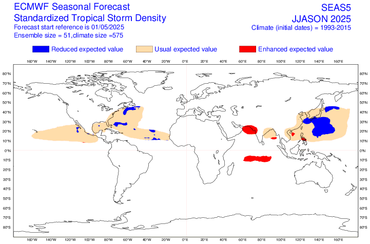
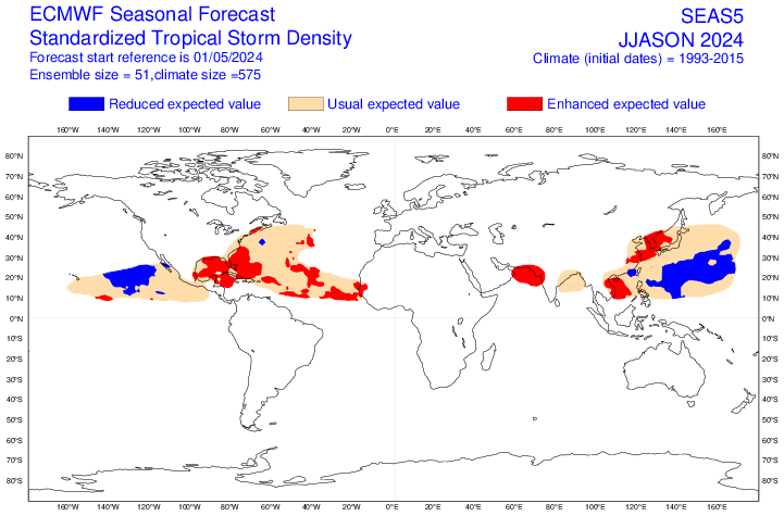
Euro seasonal update is out today - trying to get more details. https://x.com/davethroup/status/1917659431531053391?s=46
- Today
-
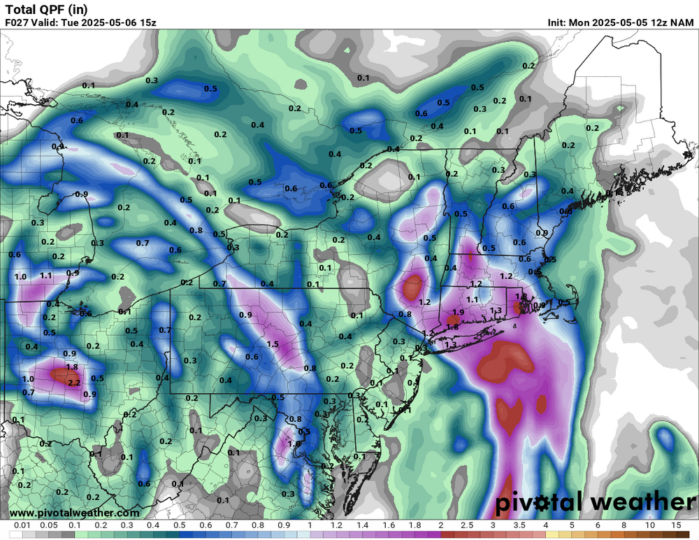
Picked up .45" rain overnight. Pretty tight gradient SE to NW on that one, friend in New Cumberland got .22" and Blizz mentioned over .8" for him.
-
This is a good take.
-

2025 Atlantic Hurricane Season
WxWatcher007 replied to BarryStantonGBP's topic in Tropical Headquarters
Ha, beat me to it. Here’s a thread looking at the environmental conditions forecast. It’s not gospel, obviously, but it’s another piece of the puzzle. -
Hot off the press: 1. The May 2025 Euro Atlantic basin forecast numbers for 2025 are pretty similar to the April 2025 Euro forecasts for 2025. They’re actually slightly less active with ACE of 110% vs 120%. That’s still an ACE of 130-140, not at all quiet. 2. The May 2025 Euro forecasts for 2025 are way less active than those of the May 2024 forecasts for 2024, but they’re not calling for a quiet season as they’re calling for near the normal for the current active era: -ACE: 110% vs 200% -# of H: 7.1 vs 12.8 -# of NS: 14.5 vs 22.8 -Activity from Gulf through NW Caribbean, Florida, and Bahamas is similar to last month’s forecast, which is notably lower than 2024 with it enhanced in May of 2024 (almost all red on the map those areas) vs mainly near normal (vs current active era) in May of 2025 (actually has slightly reduced vs active era’s normal (blue) in small areas)(see images below) In summary, the latest Euro (May) is similar to the April forecast for the 2025 season with near normal vs current active era (not quiet) vs well above normal in their 2024 forecasts. May 2025 forecast for 2025: near normal of current active era May 2024 forecast for 2024: very active
-
Local stations report about 0.8" since Friday. Hoping to add maybe a half inch to that today if all goes correctly. Drought busting? Nah. Drought avoidance? yep
-
Tropical downpour in Calvert. Heavy rain and thunder, very soupy out.
-
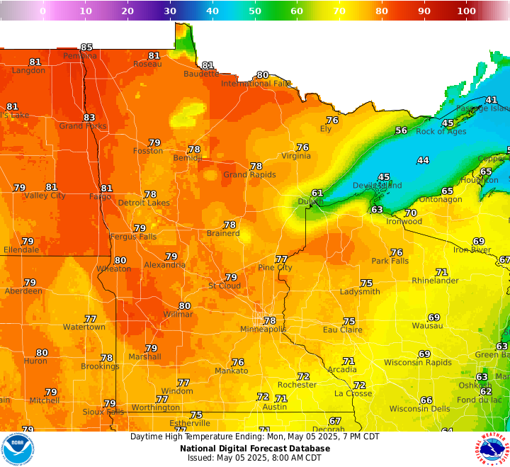
Going to be another hot one away from the Lake today. Max temps across MN will running +15-20. Almost the whole state again. Similar to yesterday.
-
Better than bullseye.
-
1.6 seconds. Just damn. The Blues had an historically bad 6v5 defense this year and it cost them.
-
Been following this thread for a week, arrived from sofla saturday in nyc and heading to Hawley,PA today...will post anything of interest later today and tomorrow. 2-3 inches of rain is very different here than 2-3 inches in sofla, we are in a drought(typical right before the rainy season starts, we are almost there) but even in the rainy season, 3 inches in an afternoon doesnt really move the needle.
-

2025 Spring/Summer Mountain Thread
Maggie Valley Steve replied to Maggie Valley Steve's topic in Southeastern States
38 this morning with clear skies at sunrise. Clouds have rolled in and showers are nearby associated with the cold core upper low. -
Chicago (and Cleveland) lakeshore would have more of a difference year-round than Detroit. Its my understanding the entire reason the NWS (or formerly Weather Bureau) moved stations is for more uniformity due to increasing influences at a station site. DTW airport absolutely has seen increasing UHI since the 1980s due to so much expanding concrete. They were a radiational cooling magnet in the 1960s-70s and that changed drastically starting in the 1990s. Detroit city airport is no longer a first-order station, but it does have a thermometer so to compare, the first 20 years DTW became the official site, DTW averaged 1.7F cooler than DET. The last 20 years DTW has averaged just 0.3F cooler. Regardless of the site locations, we dont know all the warming influences (or lackthereof) at any given time. There is no way a big city full of dirt roads in the 1870s would have the same temperature readings as that same spot would have as a concrete jungle in the 2020s. That chart, "since 1970". THAT has also been discussed multiple times now. This unusual starting date is used frequently, and it is soley to make warming look as extreme as possible. Starting a chart in 1970 ahead of the coldest winters on record will give you the biggest regression line. And as we move farther away from 1970, why cling onto using that starting point? Its now 55 years, so far more than the 30-year periods commonly used, that you wonder why not go longterm? Its because to do that, youd have to include the much milder winters of the 1930s-1950s which would really tone down that regression line. So youd have to go back to 1870 to make it a bit better. You will never, EVER see a regression line chart start in 1930. And whats funny is that that would make a lot more sense than 1970 as we are nearing the 100-year mark. Yes Ann Arbor winters have warmed 3.9F since 1970....and theyve warmed 1.4F since 1930. Regardless of the amount of warming or any discussion on temps, site changes, etc...the lower Great Lakes are not seeing any notable adjustments to their snowfall or snowcover climo other than normal decade to decade noise, although erring on the side of INCREASING somewhat rather than decreasing. So this brings me back to my original point, how is it that suddenly NYC is seeing this erratic rubber band from snowiest decade on record to a snow drought from which they supposedly may never recover?
-
No signs of 90 degree temps on the horizin. Actually, nice cooler weather coming at the end of this week for a couple of days. Temperatures will be much below normal Friday when highs will only top out in the low/mid 60s for most spots. These temps will be around 10 degrees below normal for early May. Lows Fri night will favor the low 40s up north and mid 40s elsewhere. Temperatures will moderate back to normal Saturday and then rise above normal for Sunday.
.thumb.png.f32e01e9d4d4e87e62d121e0c0d40413.png)
-
SLGT risk added today for NoVA and western half of MD. But it excludes me by like 5 miles
-
.90 so far here in 21057
-
some storms nearing you from the SE
-
0.71"


.png.4419545b25263636308cb225e6ea29c7.png)


