All Activity
- Past hour
-
I don’t want to sound like a jerk, but that’s on you. There’s over 2,000 posts on here about the potential of this storm. .
-

Southern Crippler - Get well soon Jimbo Storm Obs
WinstonSalemArlington replied to BooneWX's topic in Southeastern States
Nice -

Jan 24-26 Weekend Snow and Sleetfest Model Thread Part Tres
Amped replied to H2O's topic in Mid Atlantic
The blind squirrel NAM might win this one. Sorry I95 south of Providence, its an Ice storm. -

Jan 24-26 Weekend Snow and Sleetfest Model Thread Part Tres
NorthArlington101 replied to H2O's topic in Mid Atlantic
I’m mostly talking to myself when I’m managing expectations like that (lol) -

Central PA Winter 25/26 Discussion and Obs
Mount Joy Snowman replied to MAG5035's topic in Upstate New York/Pennsylvania
If MDT falls to 8" Lancaster is in for a world of hurt ha. I think that's going a bit too far and MDT still gets close to a foot but can't rule it out. Not good if true that upstream is underperforming. -

Extreme Cold, Snow & Sleet: SECS 1/25 - 1/26
SACRUS replied to TriPol's topic in New York City Metro
1/24 12z UKIE -
 Still virga here, at least that I've seen. The temp warmed up from 21 to 24 in the last 40 minutes.
 -

“Cory’s in LA! Let’s MECS!” Jan. 24-26 Disco
Baroclinic Zone replied to TheSnowman's topic in New England
Local PVD station MET did not rule out thunder snow. -

Arctic Hounds Unleashed: Long Duration Late January Cold Snap
WxWatcher007 replied to WxWatcher007's topic in New England
Car thermometer had -19. House was -20. -

Jan 24-26 Weekend Snow and Sleetfest Model Thread Part Tres
Warm Nose replied to H2O's topic in Mid Atlantic
Goodness the misery in here is just stupid. Enjoy what you get and STFU -

Pittsburgh/Western PA WINTER ‘25/‘26
southpark replied to Burghblizz's topic in Upstate New York/Pennsylvania
I mentioned the warm nose a few days ago after seeing certain trends and someone was like nope. And here we are lol. -

Jan 24-26 Weekend Snow and Sleetfest Model Thread Part Tres
midatlanticweather replied to H2O's topic in Mid Atlantic
The dirty sleet piles will look like sand!! -

“Cory’s in LA! Let’s MECS!” Jan. 24-26 Disco
Kitz Craver replied to TheSnowman's topic in New England
Besides the sleet discussion, any discernible trends with the Monday reach around at 12z? -
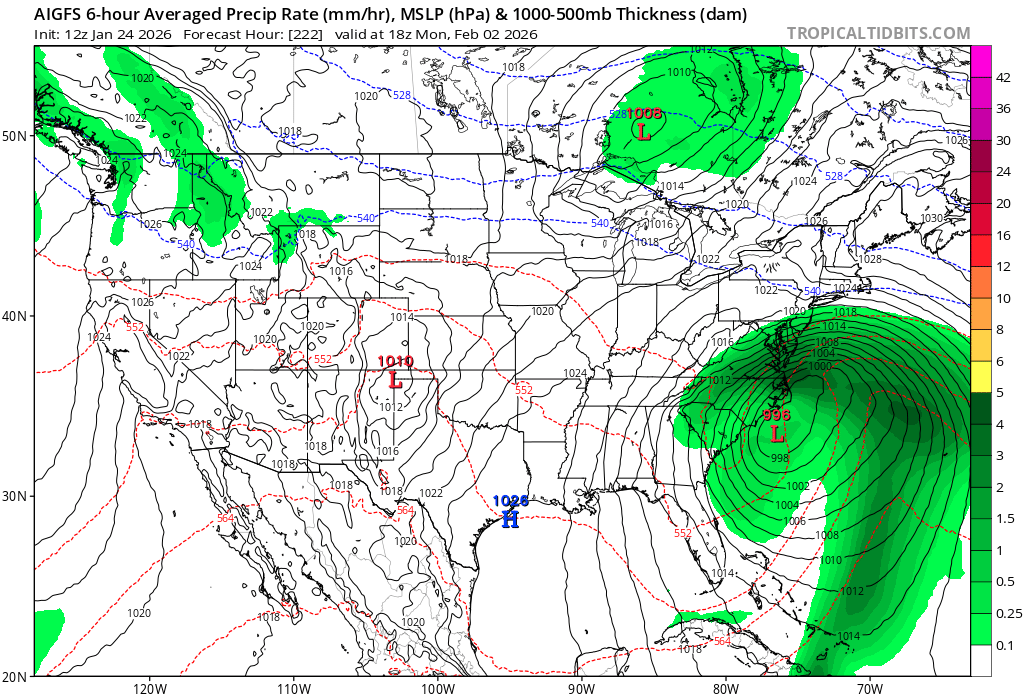
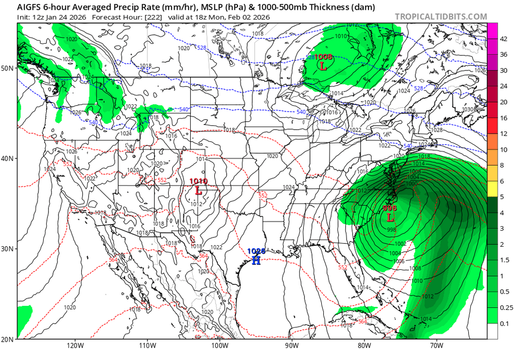
GfsAI has the storm end of next weekend. Albiet off the coast
-
There’s that GL low. AI is “learning” about those
-

Pittsburgh/Western PA WINTER ‘25/‘26
SteelCity87 replied to Burghblizz's topic in Upstate New York/Pennsylvania
My main concern because I can't either. I noticed point and click has a mix included now all the way to to Mckeesport. -
 NEGA_Dawg changed their profile photo
 -

E PA/NJ/DE Winter 2025-26 Obs/Discussion
The Iceman replied to LVblizzard's topic in Philadelphia Region
lol imagine watching the models past 48 hours and thinking anything of that sort with happen. -

Jan 24-26 Weekend Snow and Sleetfest Model Thread Part Tres
stormtracker replied to H2O's topic in Mid Atlantic
Oh, Im still excited for sure dude. Just trying to set realistic expectations based on red flags I ignore and it always comes back to bite me in the ass. Hope that thump overperforms. Im just gonna make sure I'm up for most of the thump -

“Cory’s in LA! Let’s MECS!” Jan. 24-26 Disco
metagraphica replied to TheSnowman's topic in New England
That'll be right on my doorstep. We'll see what it does. Still looking forward to a big 12" here. -
“Cory’s in LA! Let’s MECS!” Jan. 24-26 Disco
Kitz Craver replied to TheSnowman's topic in New England
There is much to suggest Boston is getting a burial, lotta maxes out that way -
On cold calm nights 747 freighters departing ohare will climb overhead at 20,000+ feet and sound like rockets. On a normal summer night you can barely hear them
-

Jan 24-26 Weekend Snow and Sleetfest Model Thread Part Tres
high risk replied to H2O's topic in Mid Atlantic
The FV3 RRFS is also going bonkers with the freezing rain. I *think* it's way, way overdone and favor the sleet bomb idea of the NAM, but this will have to watched closely tomorrow. -

Central PA Winter 25/26 Discussion and Obs
CASH_COOP replied to MAG5035's topic in Upstate New York/Pennsylvania
I agree, 8 to 10 inches before mixing and 1 or 2 inches of sleet on top is my thinking for me -

Jan 24-26 Weekend Snow and Sleetfest Model Thread Part Tres
BristowWx replied to H2O's topic in Mid Atlantic
Smells like rain. 15/-2 -

E PA/NJ/DE Winter 2025-26 Obs/Discussion
Ralph Wiggum replied to LVblizzard's topic in Philadelphia Region
AI GFS is a bomb cyclone for the feb 1-2. So close to a big hit here but scoots NE just under the region grazing us. On to the operational gfs