All Activity
- Past hour
-
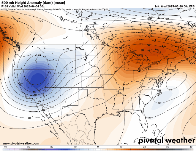
So the interior daily 80s delays a couple days into the first week of June but by June 3-4 they should be going and some of the modeling implies spotty 90 interior possible Friday-6th-at least Sunday 8th. AC will be working a bit for the interior by next weekend. 00z/28 GEFS is more aggressive with the warming so we'll monitor.
-
-
It's been pretty uneventful this year in our area in the severe department. I might have to stop using the WxWatcher007 blanket....it might actually be a curse.
- 755 replies
-
- 1
-

-
- severe
- thunderstorms
- (and 2 more)
-
we really should get serious about how we're using (ie wasting) some of the most fertile and productive soils on the planet via industrial monocropping in about the most ecologically harmful manner possible hard for me to muster sympathy for farmers when what we're really talking about with few exceptions is large agribusiness growing surplus commodities at great subsidy
-
And just like that......it's raining.
-
All this low pressure in the Northeast could continue to have a say. While it does look like we will see a warm up first week of June, the higher end heat potential may remain capped since models are now coming around to an upper low lingering nearby. So we probably see a return back to 80s. But not sure if the first 90s of the season will occur if there is too much onshore flow. Perhaps, the interior sections of NJ would have the best shot. This is looking like another over the top warm up. The most impressive temperature departures may go to our north again. Upper low lingering nearby first week of June
-
 Mabellan joined the community
 -
more dust storm related than fires but we really should get serious about how we're using (ie wasting) some of the most fertile soil on the planet growing industrial monocrops in about the most ecologically harmful manner possible
-
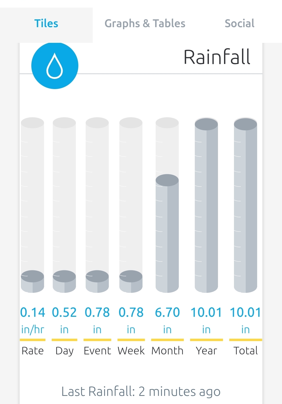
0.26” of rain 52F .
-
I know that people around here don’t like all the milder winters, but we may need a really strong El Niño like 2015-2016 to bring back at least some semblance of a STJ. Weak El Niños or warm neutrals such as 18-19 and 19-20 have been struggling against the La Niña background state. The primary driver has been the WPAC warm pool and not the actual ENSO 1.2 to 4 temperatures. I would much rather take my chances getting a very strong to super El Niño as long as the storm track is close to the benchmark. Really don’t care at this point if it’s near 60° before or after the storms or how long the snow stays on the ground. Just want to see some great snowstorms again. But as we saw in 23-24, the La Niña background combined with the very strong El Niño to pull the forcing too far west in the Pacific near the Maritime Continent. So really not sure if even a very strong El Niño can shift the marine heatwaves around which have been associated with the record WPAC warm pool. There is very little we can do from Philly to south coastal side Boston when the Northern Stream of the Pacific Jet is so strong. With Great Lakes cutters, I-95 to I-84 huggers, and suppressed Southern Stream storm tracks. The default position becomes milder winters with below to well below normal snowfall. Even the marginally colder winter this year was still around 40° near the coast on the days that .25 or more of precipitation fell. Perhaps, we can score a decent MJO 8 like we last saw in January 2022 in the coming winters. Even one good month can make the winter passable. But we have seen in recent winters how we haven’t been able to get a clean MJO 8 response due to the competing marine heatwaves and multiple areas of forcing.
-
Light rain and a chilly 50 degrees, with 0.6 in the gauge since yesterday. We're headed to south FL in a couple days -- think it'll feel hot to us?
-
Chilly rainy damp dreary
-
0.63 since yesterday afternoon light rain 51
-
Slow mover was an understatement. It's 6:15am Wednesday morning and the rain hasn't gotten to Tamaqua yet.
-
Classic rainy morning.
-

Central PA Spring 2025
Mount Joy Snowman replied to canderson's topic in Upstate New York/Pennsylvania
Low of 52 with .23” of rain. Doubt the temp budges much today. This was a pretty big forecast miss with regard to timing. I checked every single model yesterday and I don’t think a one of them had rain moving in as early as last evening, nor did they have me getting anywhere close to a quarter inch prior to 6am. Consensus was rain moving in during the pre-dawn to early morning hours. That’s wildly off for being less than 24 hours out. Anyway, should be a nice miserable walk into the capital city this morning. - Today
-
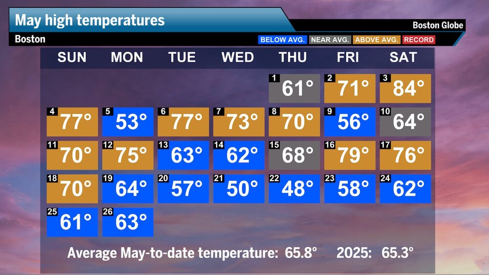
"Finally, the warmth returns. Logan Airport cracked the 70s for the first time in over a week as high pressure kept the clouds and sea breeze at bay. It’s been a wild May with the first half of the month shooting 2 to 6 degrees above average across New England, followed by a week-plus of winter-like temperatures running as low as 10 degrees below average. Boston’s average temperature for the month is still slightly warmer than normal —around three-quarters of a degree — but the daily highs have been just about average. This means we’re still seeing most of the above-average temperatures at night. Take a look below at where our daily highs stood through Memorial Day."
-
We have been stuck in a semi-permanent, default La Niña pattern for years now, even when we’ve had an El Niño, the background Niña state has still been there. It appears (at least so far) that we are following the exact same pattern again this year….
-
Just topped 1.00” since rain began midday yesterday.
-
.78 so far .26 yesterday. 52 today
-
.16” yesterday, .41” so far today. 50°
-
I think Ineedsnow is looking to take up paragliding. https://www.breitbart.com/sports/2025/05/27/paraglider-suffer-frost-bite-after-being-sucked-into-a-cloud-vortex/
-
Pouring rain currently here.
-
It’s all apples to oranges to me. Any day this time of year with practically endless daylight is miles better than the gloominess of the mid winter. And what a beauty it was yesterday!
-
There's going to be a major break between the two systems and it looks like the sun will come out Thursday afternoon just in time to see Manhattanhenge. You have to treat this like two systems not one. There will be a period of rain Wednesday afternoon to Thursday morning, then a break where the skies will clear for the afternoon. And then another period of rain Friday evening into Saturday morning.
-
Despite cloudy skies dominating the day, KSAV still had a near normal high of 87. This along with dewpoints ~74 much of the day made it feel quite sticky. We’ve had rain from thunderstorms the last 2?hrs . KSAV received nearly 1”. KSAV hasn’t had a high below 84 for the last two weeks! The month has averaged +3 for the mean temp. Despite a very wet month, the avg high there so far this month has been 87! This is very different from the significantly cooler northern SE!