All Activity
- Past hour
-
Since 18z most models have surprisingly budged toward the GFS at h5, not the other way around. 00z is gonna be interesting
-

January 24-26: Miracle or Mirage JV/Banter Thread!
Scraff replied to SnowenOutThere's topic in Mid Atlantic
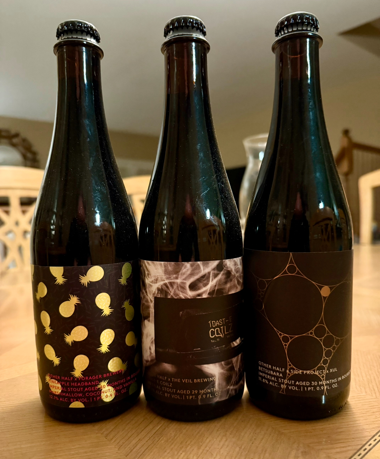
Not tried that one. I know of it for sure! I do have these waiting to share with friends one day soon though.
-

Richmond Metro/Hampton Roads Area Discussion
Conway7305 replied to RIC Airport's topic in Mid Atlantic
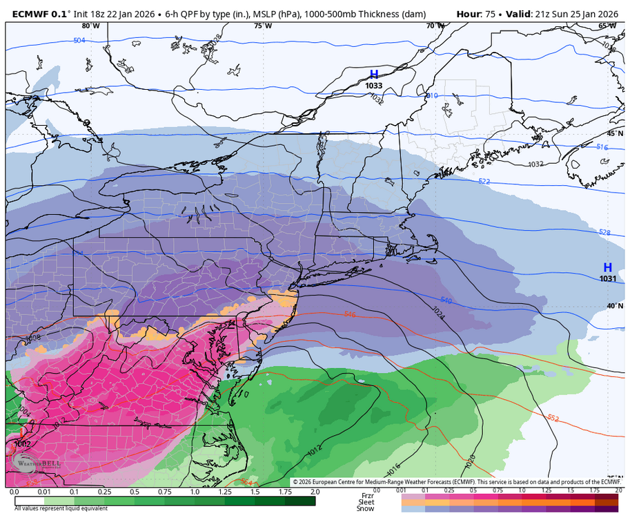
Looks like we are gonna be in a severe ice storm based off of the euro. 1.3 inches of ice is awful. Everything is still trending north. Even DC is getting significantly lower accumulations. I’ll start following the short range models now. -

January 24-26: Miracle or Mirage JV/Banter Thread!
BTRWx's Thanks Giving replied to SnowenOutThere's topic in Mid Atlantic
They shouldn't be doing it from a mobile phone! -
I’m guessing those lower totals in the southwest mountains are from the Euro amping the system so much that it changes over to just plain rain? Not complaining, if we’re not gonna get any snow, I’d rather it just be rain.
-

January 25-26 Winter Storm Potential
Ralph Wiggum replied to Ralph Wiggum's topic in Philadelphia Region
Looks the same as 12z to my eyes. -
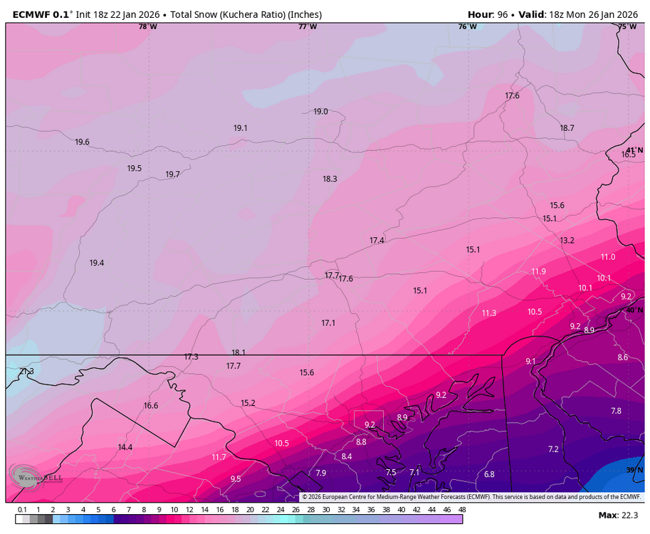
10:1 map from NYC has 6.3 Philly
-

Possible Record Breaking Cold + Snow Sunday 1/25 - Tuesday 1/27
wxman replied to TriPol's topic in New York City Metro
What site did you get that map from? Thanks! -

January 24-26: Miracle or Mirage JV/Banter Thread!
mappy replied to SnowenOutThere's topic in Mid Atlantic
How about instead of whining about it, you pay for a model subscription and lead the way next time since it wasn’t to your standards. -

Possible Record Breaking Cold + Snow Sunday 1/25 - Tuesday 1/27
psv88 replied to TriPol's topic in New York City Metro
Agreed. -

Pittsburgh/Western PA WINTER ‘25/‘26
Rd9108 replied to Burghblizz's topic in Upstate New York/Pennsylvania
One more then Ill be back for the NAM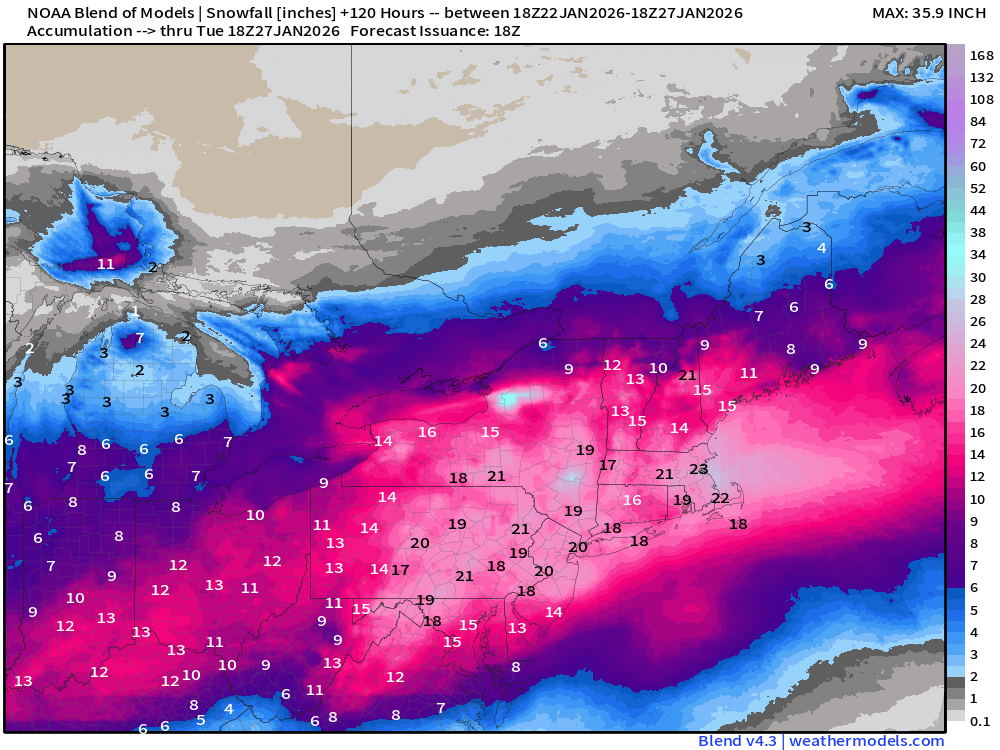
-

1/24-1/25 Major Winter Storm - S. IL, IN, MI and OH
cyclone77 replied to A-L-E-K's topic in Lakes/Ohio Valley
I'm going 6 flakes for here in the south side yard. 0-3 in the northern. -

Possible Record Breaking Cold + Snow Sunday 1/25 - Tuesday 1/27
NJwx85 replied to TriPol's topic in New York City Metro
I’m starting to think there will be a strip of 20”+ from about MMU to HPN. That’s where there should be maximum dynamics while staying all or mostly snow. But we still have 60+ hours to go so a lot can still change. -
January 24-26: Miracle or Mirage JV/Banter Thread!
BTRWx's Thanks Giving replied to SnowenOutThere's topic in Mid Atlantic
The worst play by play all day! -

“Cory’s in LA! Let’s MECS!” Jan. 24-26 Disco
RUNNAWAYICEBERG replied to TheSnowman's topic in New England
Heard it on the streets of Easton? -

January 24-26: Miracle or Mirage JV/Banter Thread!
snowfan replied to SnowenOutThere's topic in Mid Atlantic
Hey man, have you tried their deep orbit stout that's out right now? Talk about a sipper.....could enjoy that thing over an hour in front of the fire. -

-

1/24-1/25 Major Winter Storm - S. IL, IN, MI and OH
roardog replied to A-L-E-K's topic in Lakes/Ohio Valley
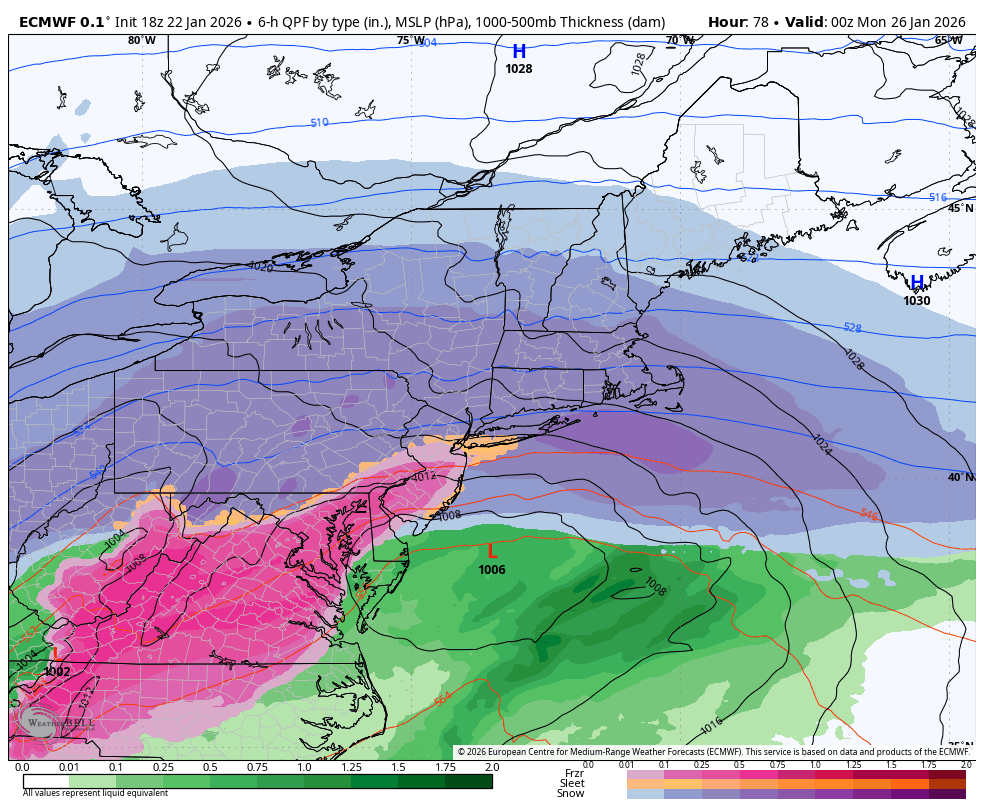
It looks like both the 18z euro and euro terminator nudged south. -

Possible Record Breaking Cold + Snow Sunday 1/25 - Tuesday 1/27
jm1220 replied to TriPol's topic in New York City Metro
I wouldn’t go higher than 8-12” for NYC/LI/I-78 to I-80 right now because of uncertainty and models like the RGEM. It’s possible the GFS is right but it’s wiser to hedge toward how SWFEs usually are which is they try to amp and trend north unless there’s the brick confluence wall to stop them, and sneaky warm layers that try to move in quicker than expected. But the GFS is another possibility if we can catch a break with a further south transfer and decent coastal development, in which case those 12-18” amounts really can happen. North of the city especially I-84 corridor I think is a lock for 12”+. We’re lucky this is a SWFE setup where it’s running into a huge overrunning dome/high pressure which means even the amped models dump 6-8” before changing over and again-the sleet will definitely have its own impact and thicken up the snow pack. -
GFS just has been so constant..... it will need to be throw out with the NAM if it's wrong on this.
-
The further north track of this winter storm will allow a thick layer of cloud cover to build in throughout the night that will keep us much warmer than we thought 2 or 3 days ago. Lows will be in the -10Fs but with no wind we`ll just be uncomfortably cold versus dangerously cold
-
January 24-26: Miracle or Mirage JV/Banter Thread!
Scraff replied to SnowenOutThere's topic in Mid Atlantic
While everyone dissects and bisects the Euro, I’m warming up the liver for Other Half tomorrow.
-
I busted out laughing when I saw this. Exactly how I feel
-

Possible Record Breaking Cold + Snow Sunday 1/25 - Tuesday 1/27
Franklin0529 replied to TriPol's topic in New York City Metro
Euro trending towards the GFS dying that primary out faster. Been the theme of the day. Couple more ticks like that an it's showtime!!! See y'all at 9pm for the nam -

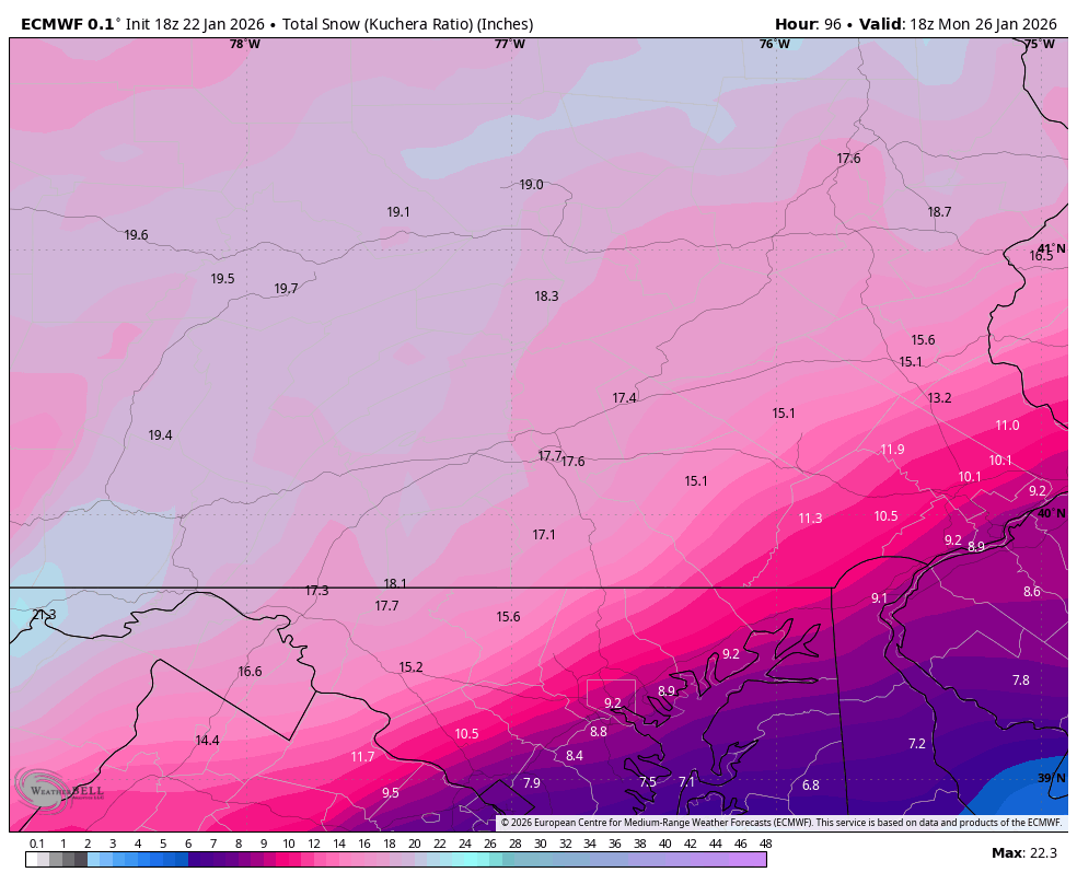
Central PA Winter 25/26 Discussion and Obs
Blizzard of 93 replied to MAG5035's topic in Upstate New York/Pennsylvania
18z Euro snow- CTP close up