All Activity
- Past hour
-
Be interesting to see the 18z GFS ensembles.
-
I hope you like McDonalds instead.
-

E PA/NJ/DE Winter 2025-26 Obs/Discussion
Ralph Wiggum replied to LVblizzard's topic in Philadelphia Region
Ai gfs -

MO/KS/AR/OK 2025-2026 Winter Discussion
StormChazer replied to stormdragonwx's topic in Central/Western States
GFS uncooperative, but considered an outlier for the time being, especially given how it has handled this storm so far,. -
NWS calling for a single-digit low of 9 in the RDU area on Sunday night. That has to be a typo, right? [Padme meme] Right?
-

Central PA Winter 25/26 Discussion and Obs
pasnownut replied to MAG5035's topic in Upstate New York/Pennsylvania
HH GFS joins the maybe it snows in CTP party. Sorta wonky evolution, but it gets snow here. -
The kicker is inevitable Mitch. We have endured 10 years of this failure my friend.
-
Take the “not” out and we are in total agreement. We got this
-

MO/KS/AR/OK 2025-2026 Winter Discussion
aggiegeog replied to stormdragonwx's topic in Central/Western States
Op GFS is an outlier in how it handles the Baja low. I would discount it for now. -
E PA/NJ/DE Winter 2025-26 Obs/Discussion
yankeex777 replied to LVblizzard's topic in Philadelphia Region
lol I’m on a cruise out of Miami. I got no choice but to fly back Sunday morning -

Possible Record Breaking Cold + Snow 1/23 - 1/25
WeatherGeek2025 replied to TriPol's topic in New York City Metro
the way we do things around here this winter is we wait until a few days before the storm hits and i open the thread, not tripod -
I’m in jackpot, but we all know the rule. 4 days you don’t want to be there. At least there is a chance for most of the board. If not we will hit cliff driving thread. lol
-
Lol. Look where the grey is. Unbelievable lol
-
GFS has 20:1 ratios for East Tennessee. .
-
There goes the money for Ruth Chris
-
I don't dislike this - precip field tugs more north compared to 12Z. If GFS had a bullseye this far out, I'd be worried - this is inline with what we typically see from the GFS in previous big events.
-

E PA/NJ/DE Winter 2025-26 Obs/Discussion
MJO812 replied to LVblizzard's topic in Philadelphia Region
What came south? -

January 25/26 Jimbo Back Surgery Storm
Thrasher Fan replied to Jimbo!'s topic in Southeastern States
Yall need to do better about showing the whole region...
-

Pittsburgh/Western PA WINTER ‘25/‘26
Rd9108 replied to Burghblizz's topic in Upstate New York/Pennsylvania
Looks like the 18z gfs -

2025-2026 Fall/Winter Mountain Thread
Sw NC weather replied to Buckethead's topic in Southeastern States
Let’s keep it down there till Wednesday. This could get fun yall if everything lines up perfectly. It’s been a while. -
It'll be a long week. Just have to hope that we don't lose the SW. Otherwise its an even longer week with the NS.
-
Geez Randy, you had to go and make a thread
-
The coldest and likely snowiest two-week period of Winter 2025-2026 lies ahead. Arctic air will move into the region tonight. Tomorrow could be the coldest day so far this season with highs struggling to reach the lower 20s and lows in the teens in New York City. Suburban areas could see single-digit lows, especially on Wednesday morning. Wednesday will be another unseasonably cold day. An even colder Arctic front will cross the region on Thursday, possibly with some snow flurries or snow showers. A frigid weekend lies ahead. Snow could arrive on Sunday. The temperature could stay below 20° in New York City on Saturday. The last time that happened was January 21, 2025 when the high was 19°. Overall, January 20th-February 3rd will likely be the coldest and perhaps snowiest two-week period this winter. The forecast WPO-/EPO-/AO-/PNA+ pattern is typically the coldest pattern in January and among the coldest during the first half of February. A persistently positive PNA will have above climatological risk of moderate or significant snowfalls. The ENSO Region 1+2 anomaly was -0.3°C and the Region 3.4 anomaly was -0.7°C for the week centered around January 14. For the past six weeks, the ENSO Region 1+2 anomaly has averaged -0.48°C and the ENSO Region 3.4 anomaly has averaged -0.68°C. La Niña conditions will likely continue into at least late winter. The SOI was +24.08 today. The preliminary Arctic Oscillation (AO) was -1.066 today. Based on sensitivity analysis applied to the latest guidance, there is an implied near 95% probability that New York City will have a cooler than normal January (1991-2020 normal). January will likely finish with a mean temperature near 31.4° (2.3° below normal). Supplemental Information: The projected mean would be 1.2° below the 1981-2010 normal monthly value.
-

January 25/26 Jimbo Back Surgery Storm
WinstonSalemArlington replied to Jimbo!'s topic in Southeastern States
-
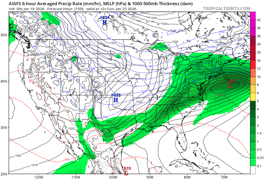
As for the AIGFS, look what's shown up over the Dakotas this run that nothing at 12z and didn't exist at 6z. Our little friend again.