All Activity
- Past hour
-
Heavy Pop-up shower here in Melville.
-

Junorch obs and discussion 2026
Damage In Tolland replied to Damage In Tolland's topic in New England
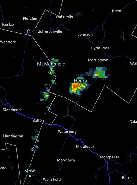
Torch !
-
Brief shower, just enough rain to wet the laundry I had hanging outside
-

2026 Mid-Atlantic Severe Storm General Discussion
SnowenOutThere replied to Kmlwx's topic in Mid Atlantic
I’m sorta feeling today. At the bare minimum we’re over 1000 SCAPE right now so I think we will at least get some storms this evening. -
If I was any good at stats I'd tot the anomaly from the state avg, and the sigmas. Its been a long time since OH valley has been the center of the action; I ken when I was young tornado alley included IL, IN, OH.
-
HRRR has been showing some very heavy rain for a little south of NYC, and we can see that storm on radar now. Looks like some heavy stuff will be going into Mercer, Middlesex and Monmouth. It might miss me just to the south but it's going to be close.
-
It's backfilling a little bit, and pouring here. We'll see what the rest of it as it swings in from the SW. NNJ looks like it's got a shot maybe.
-

2026 Mid-Atlantic Severe Storm General Discussion
batmanbrad replied to Kmlwx's topic in Mid Atlantic
for those hoping for at least drought-denting rainfall, WPC shares some decent possibilities in their latest ERO/ERD: ...Central Appalachians to Northeast U.S... Surface low currently analyzed over the western Ohio Valley will gradually lift to the east-northeast with an expectation for the low center to exit off the northern Mid Atlantic coast, dragging a cold front through the Mid Atlantic and Ohio Valley and lifting a warm front ahead of the disturbance. The current indications are for convection to spawn over the eastern Ohio Valley by the early- afternoon as mid-level ascent and increased surface forcing aided by the cold front and area of low pressure will trigger convective initiation just upstream of the terrain in WV and western PA. This area of thunderstorms will migrate eastward, entering a favorable environment within a modest warm sector as you move east of the Appalachian front. Shear profiles across the Mid Atlantic are anticipated to be greatest north of the Mason Dixon, however shear magnitudes are still capable for enabling stronger mid-level mesocyclones to materialize and hold as far south as I-66 leading to prospects for heavier thunderstorms to hold across the urban corridor extending from northern VA up through NYC and western LI. HREF probs for >1" are pretty high for both the neighborhood and EAS fields meaning there's a consensus for areas of heavy rainfall to impact much of the Mid Atlantic with the most pronounced signatures into the Central Appalachians and the urban centers, both are which are susceptible to flash flood concerns. Antecedent soil moisture is dry, so the initial burst of rainfall will be beneficial to those areas not tied completely by urban infrastructure, however, there's a sufficient signal in the QPF means to maintain the previous SLGT risk inherited for the region as 00z CAMs maintained their depictions on a multi-round cycle of convection moving into the area with pockets of 2-3+" forecast across portions of the aforementioned areas. -

2026-2027 Super El Nino
George001 replied to Stormchaserchuck1's topic in Weather Forecasting and Discussion
I don’t even disagree with Adam about this upcoming winter in particular (the raging super El Niño forecast is backed up by current obs + guidance, it’s already approaching borderline strong territory in June). No issue with 97-98 as an analog either, but calling you a wishcaster for claiming 09-10 is an analog when that winter wasn’t even good for you is…. out there. I don’t see why having years like 09-10 and 57-58 as ENSO analogs is so crazy, it’s the weenie implication that those analogs = an eastern burial that is an unsupported leap. Those were strong El Niños (57-58 a high end strong event), wet, and neither were frigid years like 14-15 (Adam is right to push back on the people calling that season an analog). Hell, it could be argued 57-58 wouldn’t even be that good of a winter today if we ran back that same pattern and adjusted for CC. Sure, this El Niño is stronger and more east based than 09-10, but it’s not crazy to include it as an analog. Including it as an analog does NOT mean “the mid Atlantic is getting buried again”, that required an insane sequence of luck that likely won’t be repeated in any of our lifetimes much like 14-15 in Boston. 09-10 wasn’t that cold either, it was near normal temps. I don’t think that’s a wishcast analog. 09-10 without the severe -NAO (my understanding is we are in the opposite solar phase to that year) may not even be that good of a winter. I don’t know…. If you dig into these analogs more closely there are ways to debunk the weenie narratives without name calling. On the other hand, 97-98 is an excellent analog, that was an eastern based super Nino which is a strong match to how this event is developing. However, as several people pointed out that doesn’t necessarily mean snowless. A 97-98 type pattern with a bit less warmth (would need some of the non ENSO factors to break right for this) could absolutely lead to a normal snow winter. The seasonal models are likely too cold, but the coastal track and wet eastern winter pattern is in line with ENSO. The big question is how much of that precip will be snow vs rain. I’m personally on the warm and BN snow side of the argument, but for fucks sake it’s at least worth hearing people with differing opinions out. Adams ENSO posts have been solid, but ya know it’s uh possible to just ignore weenies if you don’t like them and enjoy the summer if you like warmer weather. A lot of people like it warm and aren’t huge fans of the cold and snow, and those people mostly are spending time outside and couldn’t care less about what people post online about the weather. -
Looks like some lower level dry air or mid level dry air knocking down what’s attempting to fall in SNE? The look on radar between KOKX and KBOX is significant in SNE areas… Glad we are getting some rain regardless!
-
Cell developed rapidly NE of Wilmington, DE. and is moving right up I-95 towards Philly.
-
Yeah CAMs have been *relatively* consistent with pushing some sort of loose cluster of storms through the DC area.
-
Pouring again in Brightwaters. Pop up showers. Better than nothing
-
Mesoscale Discussion 1253 NWS Storm Prediction Center Norman OK 1225 PM CDT Mon Jun 22 2026 Areas affected...portions of the central Appalachians into the Mid-Atlantic Concerning...Severe potential...Watch likely Valid 221725Z - 221930Z Probability of Watch Issuance...80 percent SUMMARY...Thunderstorms will increase in coverage and intensity over the next couple of hours. Scattered damaging wind gusts, isolated hail and perhaps a tornado will be possible through evening. A severe thunderstorm watch will likely be needed by 19z. DISCUSSION...Thunderstorms over the higher terrain of WV and vicinity are gradually increasing in intensity this afternoon as gradual destabilization occurs. Downstream from higher terrain across portions of VA into MD/DE, southern NJ and southeast PA, stronger heating is occurring within areas of mostly clear skies. Higher quality moisture across eastern VA has been streaming northward toward southeast PA/southern NJ and ensuing stronger destabilization is noted. Enhanced westerly flow is apparent in early afternoon mesoanalysis and 12z regional RAOBs. This should allow for sufficient deep layer shear for storm organization. Thunderstorm clusters will pose mainly a risk of damaging wind gusts given steep (greater than 7.5 C/km) 0-3 km lapse rates and PW values around 1.75 inches. Some forecast guidance suggests sufficient clustering/outflow consolidation may occur in the vicinity of northern VA/MD and a forward propagating cluster/bowing segment could develop and track northeast with time toward southeast PA/NJ. This corridor aligns with the corridor of stronger midlevel westerlies, and may pose a relative greater severe risk compared to points further south into southern VA and NC where flow is weaker. If this scenario unfolds, damaging wind potential will increase. Given modest 0-1 km SRH across the region, a tornado or two also could occur, though the damaging wind risk is expected to be the primary hazard into early evening. ..Leitman/Hart.. 06/22/2026 ...Please see www.spc.noaa.gov for graphic product... ATTN...WFO...PHI...AKQ...CTP...LWX...RAH...RNK...PBZ...RLX... GSP...MRX...JKL... LAT...LON 40497808 40747686 40807597 40757507 40587476 40047426 39677428 38847474 38197525 37847570 37297702 36447933 36097997 35748149 35858253 36268338 36608350 36928354 37748308 38378233 39148140 40177908 40497808 MOST PROBABLE PEAK TORNADO INTENSITY...UP TO 90 MPH MOST PROBABLE PEAK WIND GUST...55-70 MPH MOST PROBABLE PEAK HAIL SIZE...UP TO 1.25 IN
- 831 replies
-
- 2
-

-

-
- severe
- thunderstorms
- (and 7 more)
-

2026-2027 Super El Nino
LakePaste25 replied to Stormchaserchuck1's topic in Weather Forecasting and Discussion
This morning it was in the 50s and was raining. Much more typical of what I’d expect for a pre-super Nino summer around here as 1972, 1982, and 1997 had a handful of these days in June and July. -
Watch coming by 3pm
-
Absolutely pouring. I thought the rain shield was down south and wondering why we are getting soaked. Can’t miss right now.
-
lol we are gonna be more than halfway through our avg 90-deg days before the end of June.
-
Radar seems to favor NYC/north later
-
AL in 2011 with 146. “Padded” with 62 on April 27. KS in 2008 had 187. TX in 2015 had 244. Still a few outbreaks away from touching that in IL.
- Today
-
the dew has fallen into the low 60s here, but its 92. doesnt exactly feel unstable out there. the extreme dryness plays a big part.
-
Well it did rain.... Had 5 drops on my windshield.
-
I’m jealous. Been mostly cloudy up here all morning and mild. Hoping we can get some sun up here for a bit. I’m gonna be out west for a couple weeks so I’d like to see/hear some storms prior.
-

2026-2027 Super El Nino
michsnowfreak replied to Stormchaserchuck1's topic in Weather Forecasting and Discussion
I agree 100%. But actually, at least 1 in here IS implying the lowest snow totals will repeat. Analogs are a tool like models. You could have everything align nearly identical to a previous year and the weather will never be replicated verbatim. Assuming winter is mild overall, there will likely be some significant Fall cold shots and early snows here in the lakes, that is a very common strong nino trait. -

2026-2027 Super El Nino
BlizzardWx replied to Stormchaserchuck1's topic in Weather Forecasting and Discussion
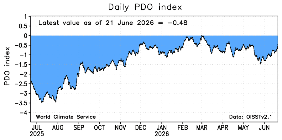
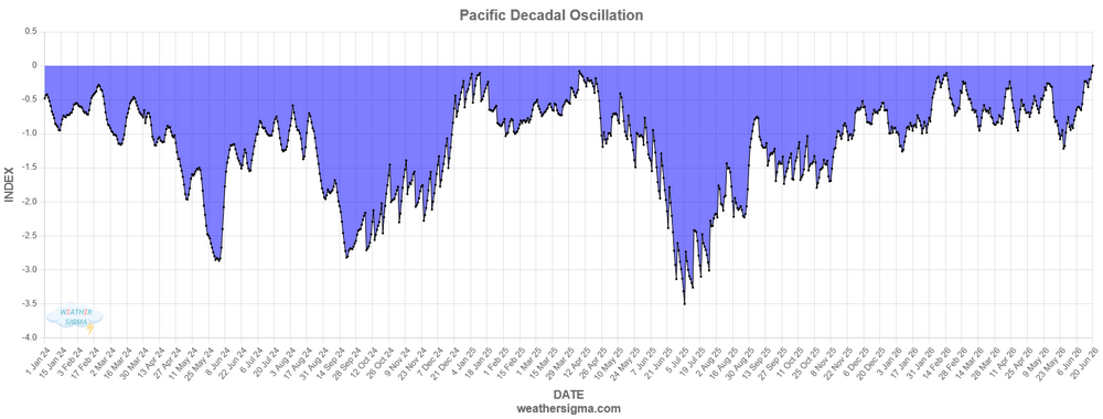
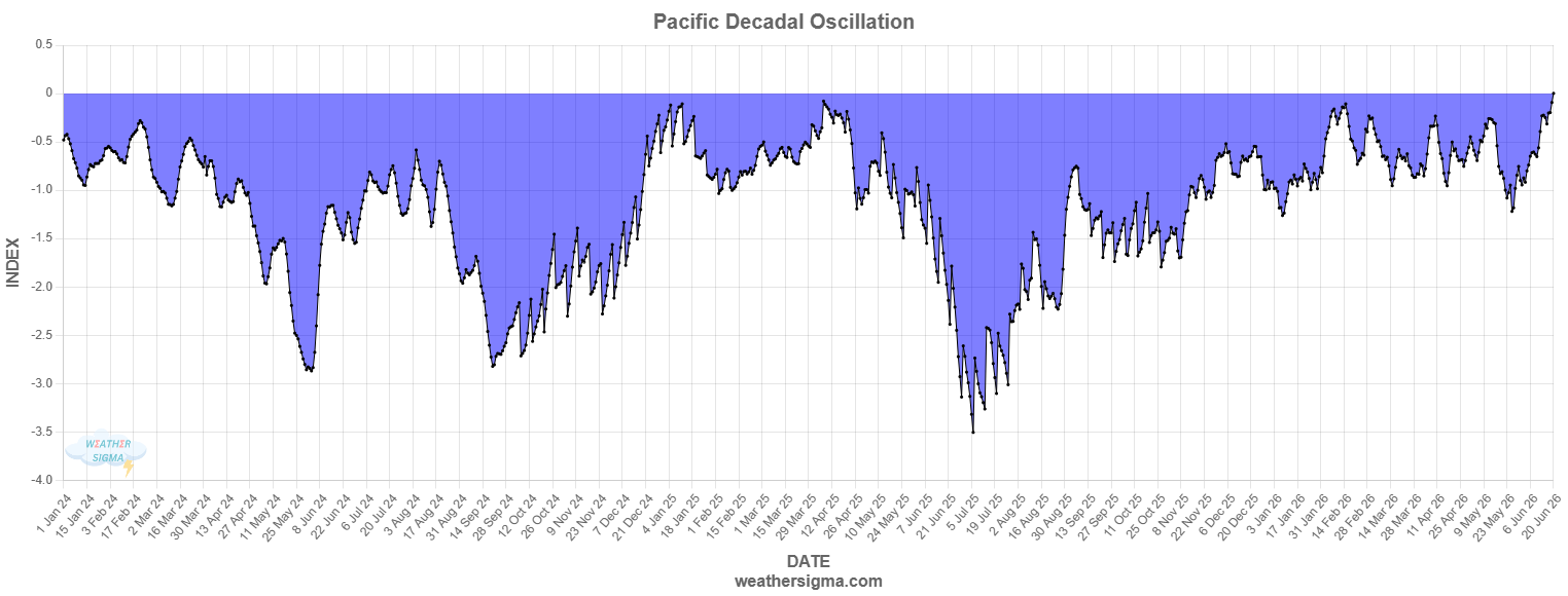
My numbers run slightly higher than WCS, and showing a rise back to around 0. Last year at this time we were tanking the value. In 2024 we were recovering somewhat after already tanking, but values were still much lower than now. In my mind its clear that things are really changing from where we've been the last 10 years. Yeah, maybe we aren't headed for a robust +PDO, but it feels like neutral to slightly positive could be in the cards.