All Activity
- Past hour
-
Sometimes …. It’s all that’s needed ….. as always……

-
My problem has been lanternflies. I unfortunately found out we have a tree of heaven in our backyard. Those bastards are everywhere.
-
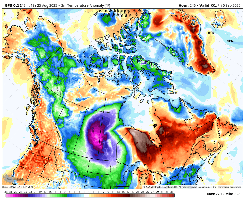
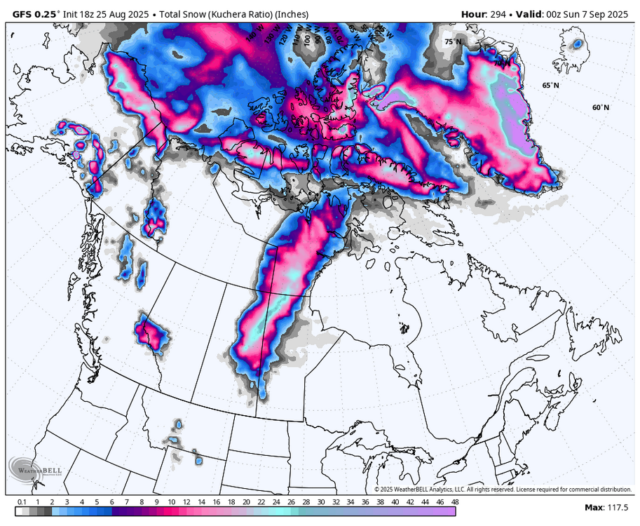
First central Canada blizzard in September (WB 18Z GFS). Let the fun begin!!!!

-
Just a perfect evening for a stroll (I won't complain about this year's particularly persistent crop of mosquitos)
-
Another rip current day at the beach. Longest stretch of ocean swim restrictions in a long time.
-

2025 Spring/Summer Mountain Thread
Met1985 replied to Maggie Valley Steve's topic in Southeastern States
This afternoon has turned straight to Fall. Cloudy with a breeze. Had a high of 71 with a current temp of 62 degrees. -
 marsman changed their profile photo
 - Today
-
If we had a year that was typical 100 years ago, people would think they’d moved to Boston or Portland, ME.
-
Hit 93 at 2:30pm.
-
The fact that 1.2 has cooled significantly over the past 2 weeks plus the northern pacific ssta’s raises the possibility of a non ratter.
-
RMNP web cams are all rainy tonight
-
 Cooler air will over spread the region tonight. High temperatures will top out mainly in the upper 70s and lows will fall to lower 60s in New York City through at least Friday. Outside the City, lows in the 50s will be widespread. The cool weather will continue during the weekend. On account of the cool air, August 2025 will be among the five coolest Augusts since 2000. There will be higher-than-climatological risk of at least one period in September with highs in the upper 80s or perhaps 90s. Summers similar to the current one have had September highs of 90 or above about 10 percentage points above that for all other years. The ENSO Region 1+2 anomaly was +-0.1°C and the Region 3.4 anomaly was -0.4°C for the week centered around August 20. For the past six weeks, the ENSO Region 1+2 anomaly has averaged +0.45°C and the ENSO Region 3.4 anomaly has averaged -0.28°C. Neutral ENSO conditions will likely continue into early autumn. The SOI was +21.06 today. The preliminary Arctic Oscillation (AO) was +0.610 today. Based on sensitivity analysis applied to the latest guidance, there is an implied 99% probability that New York City will have a cooler than normal August (1991-2020 normal). August will likely finish with a mean temperature near 73.8° (2.3° below normal). Supplemental Information: The projected mean would be 1.4° below the 1981-2010 normal monthly value.
 -
Something about a frog boiling...
-
AI and AIFS are not
-
Same.
-
Wasn’t it like top 3 hottest before August started? Yes August will drop it down the list.
-
What a great day, 54 this morning and 74 this afternoon for the high. That's impossible to beat in August.
-
Which is why I’m glad I didn’t go with a major EC hit, though I was tempted.
-
It got back up to around 89 after I posted this but 89.1 was the max! We did not break 90 and we look locked in to stay below it the entire month, WOW! Currently 86 with relatively low humidity again, dewpoint 62
-

2025 Spring/Summer Mountain Thread
Buckethead replied to Maggie Valley Steve's topic in Southeastern States
Had a high of 61 today in Wolf, already down to 55 currently. Sent from my SM-S908U using Tapatalk -
Humidity was oppressive though.
-
Consistent
-
Same here
-
I didn’t look carefully until writing the post, but once I looked deeper, Hugo and Fran stood out as truly anomalous beast storms. First, once AOML resolved Hazel’s landfall intensity at 115 knots, it left Hugo as the sole strongest landfall (120 kt) north of Florida on the east coast dating back to the 1850’s! https://www.aoml.noaa.gov/hrd/hurdat/All_U.S._Hurricanes.html Fran’s landfall was near the top intensity for NC northward. The damage video surveys following Fran are reminiscent more of the major GOM landfalls than a typical east coast hurricane. The videos show rows of homes that were completely swept away Opal and Ivan style by a 12-ft storm surge/violent wave action on North Topsail Beach. Future research for me would include why it’s not so hard to get a Category 2 landfall in NC, but crossing that threshold into major territory takes a special alignment with half-centuries in between.
-
IT'S BAZ MATE NOT JIM
-
yup, dust control !