All Activity
- Past hour
-
Depends on strength and other factors. Right now we are looking at a weak La Nina.
-
The heat has definitely brought on flash drought conditions for much of middle & west TN. Moderate drought in some places already. Heading into the drier months is not helping either. Hope for a tropical system to be a drought buster otherwise.
-
The summer of cloudy, humid, swampy continues. The NAM has been way overdone with rain. The HRR looks more credible imo. It just has a bit of drizzle for basically the entire week.
-
50’s and rain for many tomorrow ?
-

Hurricane Erin: 140 MPH - 937 mb - NW @ 10
TheDreamTraveler replied to BarryStantonGBP's topic in Tropical Headquarters
Damn Erin looks like shit right now lol -

Mid to long range discussion- 2025
WinstonSalemArlington replied to wncsnow's topic in Southeastern States
CLT 10-day -
Because August should be hazy hot and humid. Soon summer is ending. All the late night fun, all the trips to get ice cream, all the beach trips. The joy of sitting at the beach….those warm nights… That all comes to an end soon. So yeah, keep it as hot as long as it can be. We have all winter to be in the 60s.
-
multiple times you have said that this type of weather sucks. blue skies, low humidity, temps in 70's. what is it that sucks about this weather?
-
I mean that’s a good thing.
-
naso much
-
49
-
Did this life threatening situation materialize?
-
 Mt Holly: as an upper level trough approaches, the same trough that will eventually carry Hurricane Erin out to sea. Rain chances are around 20-40% across the region and any precipitation will be light and non impactful. Cloudy and cool otherwise with highs in the mid to upper 70s.
 -
Tropical Storm Watch for Worcester County.
-

Hurricane Erin: 140 MPH - 937 mb - NW @ 10
NJwx85 replied to BarryStantonGBP's topic in Tropical Headquarters
Wow, naked swirl alert. The center is closed to getting exposed. No model had this getting sheared apart this badly. -

Hurricane Erin: 140 MPH - 937 mb - NW @ 10
Hotair replied to BarryStantonGBP's topic in Tropical Headquarters
True. The cold wake for Erin should be substantial given that it exploded to a 5 while in the lower latitudes and has since been churning at a deliberate pace. Doubtful the train of oranges and lemons currently trailing Erin can borrow anywhere near as much energy as she did over a 200 miles radius from its path. -
This damp drizzle sucks for trying to load up the truck for moving my kid to college
-
I think there were more 30s too.
-

Hurricane Erin: 140 MPH - 937 mb - NW @ 10
olafminesaw replied to BarryStantonGBP's topic in Tropical Headquarters
Erin has gone from looking like a West Pacific beast to a West Pacific beast as it drifts off shore of Tokyo. A shell of it's former self. Scrambled eggos. -

2025-2026 ENSO
PhiEaglesfan712 replied to 40/70 Benchmark's topic in Weather Forecasting and Discussion
The GFS showing a Sandy-like storm: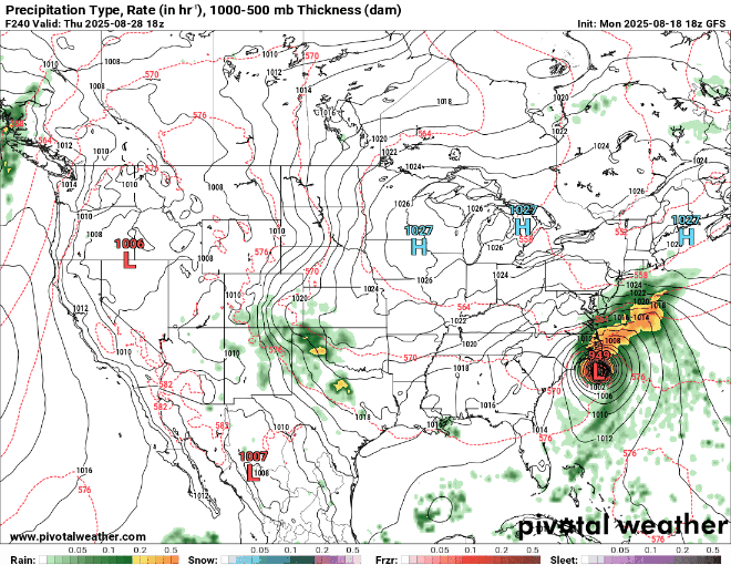
-
Yep, thank God it was sunny. Plenty of good beach weather and some heat thrown in. But this stuff sucks currently.
-

Hurricane Erin: 140 MPH - 937 mb - NW @ 10
wthrmn654 replied to BarryStantonGBP's topic in Tropical Headquarters
The more important part of the forecast is that model guidance has continued to show Erin growing in size, and the wind radii have been made larger in the new NHC forecast. This new forecast now brings tropical-storm-force winds very close to the Mid-Atlantic and southern New England coast later this week. Erin's expanding wind field will result in rough ocean conditions over much of the western Atlantic. -
Might want to zoom and take a look at the numbers.
-
Hurricane Erin: 140 MPH - 937 mb - NW @ 10
wthrmn654 replied to BarryStantonGBP's topic in Tropical Headquarters
There is not much change to the track forecast reasoning, with the hurricane still expected to recurve over the western Atlantic between the U.S. east coast and Bermuda over the next 3-4 days. The main highlight of the new forecast is that much of the track guidance, including the consensus aids, have shifted slightly west of the previous NHC prediction during the first 2-3 days. The new NHC forecast is very close to the TVCA and HCCA consensus aids during the first 48 hours, and then closer to the TVCA aid beyond 48 hours. It should be noted that there is still some space for additional adjustments to the track forecast, particularly beyond 48 hours with the HCCA aid lying along the northwestern edge of the guidance envelope. -


