All Activity
- Past hour
-
6 PM LWX Regional Weather Roundup has Frederick reporting a temperature of 102 with a heat index of 104. It may be time to get that thermometer out of the sun.
-
It’s deceiving. I was under 2 showers that seemingly looked meh on radar and got an inch already.
-

2026-2027 Super El Nino
40/70 Benchmark replied to Stormchaserchuck1's topic in Weather Forecasting and Discussion
Yea, both can be true.....Nino is epic in the tropics, but we still have some MC competition in mid latitudes. -
Radar looks pretty anemic, frankly. .
-
We deserve this upcoming weather stretch!
-
 I'm at ~1,200 ft in Burlington CT and twice say lightning flashes over Rutland VT... About 135 miles away.
 -
A cooler regime is in place and will remain in place through the remainder of July. Highs will generally reach the lower 80s through much or all of the remainder of July. The warmest spots could reach the middle 80s on occasion. The ENSO Region 1+2 anomaly was +3.6°C and the Region 3.4 anomaly was +2.1°C for the week centered around July 15. For the past six weeks, the ENSO Region 1+2 anomaly has averaged +3.20°C and the ENSO Region 3.4 anomaly has averaged +1.82°C. The ongoing strong El Niño will continue to strengthen through the summer. The SOI was -17.36 yesterday. The preliminary Arctic Oscillation (AO) was -0.144 today. Based on sensitivity analysis applied to the latest guidance, there is an implied near 72% probability that New York City will have a cooler than normal July (1991-2020 normal). July will likely finish with a mean temperature near 76.6° (0.9° below normal). Supplemental Information: The projected mean would be 0.1° above the 1981-2010 normal monthly value.
-
It'd be funny if Judah Cohen comes up with an index to correlate forest fire smoke to a snowy and cold winter.
-
The next 4 days look incredible. Time to turn off the AC for a few days
-
Don't you worry, the snow line will stay firmly north of the mason Nixon line all winter long
-
Agreed, lol I am in favor of them just standing pat or perhaps consider Rogers and Ward for trade. To me we are not going to get anything for Adley that will help the organization anytime soon--and the injuries are only gonna lessen the package, imo I mean for your former 1:1 it better be in your Top 2 prospects and that's just a start.
-
A beautiful evening to see a free Fleetwood Mac knockoff band at Wisp. 70 with a breeze - heading to the upper 40s tonight. Yes please and thank you.
-
Can already feel a significant difference in the air.
-
-
 Did daddy-o @CoastalWx lock you out of your house again?
 -
Maybe he’s smart enough to block you. He's a generous soul so unlikely he will.
-
 I recall in the summer of 2019, a friend of mine was driving S on I95 getting close to 128 junction, and he could see DSNT LTG in CB tops to his S. Turns out it was about 130 mi away over the ocean! Not often you see LTG that far away in New England, minus higher mtn tops. So I bet if it was night, you would have seen LTG in these CB tops! Farthest I have ever seen LTG in New England was about 15 years ago driving N mid-evening on I93 at the 495 junction. Saw a dull orange flash on the N horizon. Cell was close to BML, so about 120 mi.
 -
Already at an inch of rain
-
I feel your pain.
-
More NW flow! And talk about the mean trough position remaining in the E! The 12z ECMWF gets really amp'ed in 7 days. So all sorts of convective possibilities, even if it is just big rains/lots of LTG! Type of pattern is that if we can get any TC development off the E Coast, odds are we can get at least its tropical moisture here. Some areas did quite well for rain ydy. Max I could find for the DC area was 3.75" at Highland MD. For SE VA where the biggest rains were fcst, ending 7am EDT, max of 6.00" at Kilmarnock VA (more fell after 7am). So the HRRR did ok, and RRFS overdid it, esp. over SE VA, but at least it had the location of the max rainfall correct. Still getting a feel for the RRFS. I've heard not so good things about it here and there, but it is still non-operational, so maybe it will be adjusted/tweaked by the time it goes operational in Oct.
- 1,454 replies
-
- 1
-

-
- severe
- thunderstorms
- (and 7 more)
-

Spring/Summer 2026 Pattern Discussion Thread
Jed33 replied to Carvers Gap's topic in Tennessee Valley
I just got home and checked the station. Looks like I recorded 3.77in today. I’m reminded why it’s hard to use Radarscope to perfection, but it generally will give you an idea. If I were to literally go down the hill in my neighborhood to the lake though, they have definitely received over 4in and then just across on the other side of the lake is Bean Station and Mooresburg. There, over 5-6in of rain fell. -

Central PA Summer 2026 Discussion/Obs Thread
Superstorm replied to Voyager's topic in Upstate New York/Pennsylvania
Chuck Rhodes is an icon for anyone growing up in central PA. . - Today
-
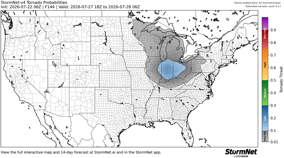
Was skeptical of StormNet at first because it’s very AI driven but it’s done a damn good job. Something to watch for Monday.
-
 Don’t worry, next week when I’m on vacation looks like shit in that area
 -
 What a great visual post!









.thumb.JPG.418e8a9a2902ae687ec35ff4bc0e038e.JPG)