All Activity
- Past hour
-

E PA/NJ/DE Spring 2026 Obs/Discussion
Hurricane Agnes replied to PhiEaglesfan712's topic in Philadelphia Region
Thankfully I picked up 1.02" of rain over the 2-day weekend most of it Saturday night. Had put down some fertilizer hoping I wouldn't jinx it and didn't. More is forecast for the middle of the week. Got up to 70 for a high after a low of 40. Currently a sunny 68 with dp 44. -

Potential Sever Weather Outbreak 4/27/2026
Jackstraw replied to pen_artist's topic in Lakes/Ohio Valley
Not sure why it lapsed. A secondary line through there was pretty well modeled. -
Steady stratiform rain all day. We needed a good deep soak, could use more but this is a great start. Got soaked at work and didn’t mind one bit. Now my grass might start to grow.
-
.thumb.jpg.6a4895b2a43f87359e4e7d04a6fa0d14.jpg)
Central PA Spring 2026 Discussion/Obs Thread
Yardstickgozinya replied to Voyager's topic in Upstate New York/Pennsylvania
The cellular damage from that freeze didn't show right away.It really sticks out like a sore thumb now when you look at plants and bushes the last 2 Three days ago, japanese maples looked fine.Today, pretty much everyone i've come across. looks just like this one.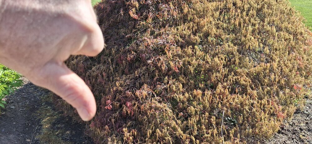
-

Potential Sever Weather Outbreak 4/27/2026
Tim from Springfield, IL replied to pen_artist's topic in Lakes/Ohio Valley
ILX has done a rare backwards local extension on Tornado Watch #160 to add 15 more counties to the watch--all the way back to Springfield and Jacksonville--and basically put all counties along and south of I-72 in a tornado watch for this evening. This despite no sun appearing at all in the Springfield area and three rounds of severe storms and/or heavy rain since around 2-3am: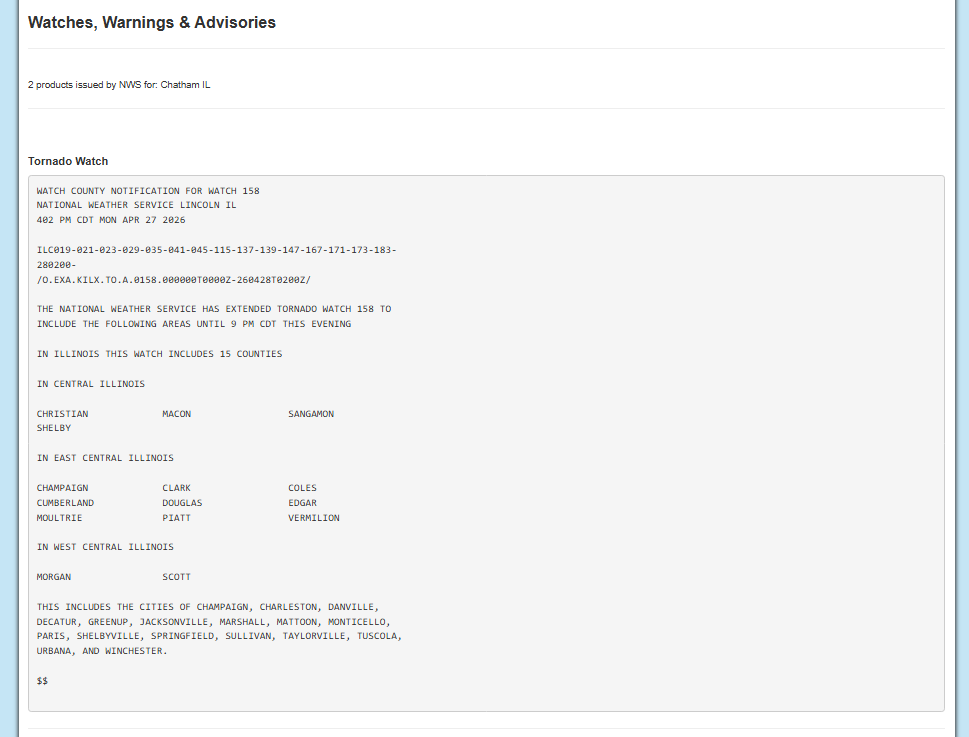
-

Potential Sever Weather Outbreak 4/27/2026
Lurkess replied to pen_artist's topic in Lakes/Ohio Valley
Thank you for your emoji. More often than not I'm ignored here, so that means a lot to me. I used to have a wx forum where we had a lot of fun. I miss that. SE Illinois looks to be bad. SW Indiana as well. The confluence of Wabash and Ohio rivers are my location. I've spent hundreds of hours watching the barges go by. The locks and dams are especially cool. I'd be happier in a cooler, less unpredictable area though. Now that we're in PDS, well I'm extremely worried. Be safe everyone. That's sincere btw. -

Potential Sever Weather Outbreak 4/27/2026
TheNiño replied to pen_artist's topic in Lakes/Ohio Valley
Milwaukee has 35,000 without power as well -

Potential Sever Weather Outbreak 4/27/2026
WestMichigan replied to pen_artist's topic in Lakes/Ohio Valley
Nearly the entire SE corner of my county is without power. I recorded a peak gust of 19MPH before the electricity went off. Someone else must have had a much higher gust nearby because that would cause parts of 2 counties to lose power. -

Central PA Spring 2026 Discussion/Obs Thread
WmsptWx replied to Voyager's topic in Upstate New York/Pennsylvania
Mow #1 in the books -
Moss posting
-
Central PA Spring 2026 Discussion/Obs Thread
Yardstickgozinya replied to Voyager's topic in Upstate New York/Pennsylvania
The above was written a few days ago. The main abortions of fruitlits has been occurring for the last three days. -
Central PA Spring 2026 Discussion/Obs Thread
Yardstickgozinya replied to Voyager's topic in Upstate New York/Pennsylvania
https://extension.psu.edu/pennsylvania-tree-fruit-phenology-report-april-21-2026/ Frost Ring Formation Throughout much of the state overnight between April 20-21, temperatures posed a serious risk to fruit crops. Apple, peach, and pear crops may have experienced varying levels of damage depending on developmental stage and site-specific conditions. Apples are at petal fall in Adams County and at full bloom in Center County. Although fertilized flowers and young fruitlets are less sensitive to freezing temperatures than blossoms at full bloom, exposure to critical temperatures may have resulted in tissue injury, leading to embryo damage, fruitlet abortion, or subsequent quality defects. There was also potential for frost ring formation under the forecasted conditions -
Looks like the models are doing Lucy with the football again, on the rain in my area. Went from 1+ inch totals to the Euro splitting the rain and mostly missing my area. It spit out .14 inches for the next 7 days here now.
- Today
-
1.33” here. Definitely needed.
-
Did touch 70 today - gorgeous out.
-

Central PA Spring 2026 Discussion/Obs Thread
mahantango#1 replied to Voyager's topic in Upstate New York/Pennsylvania
That's terrible news regarding the fruit trees. -
Hmmmm... afternoon AFD from LWX about Wednesday. Granted we will likely fail... but only chance for a while The better chance for showers and some thunderstorms would be on Wednesday as a brunt of the upper trough moves toward the Eastern Seaboard. A remnant MCV will likely be wrapped up in this larger scale trough, the timing and amplitude of which will dictate the extent of any strong to severe weather in the Mid- Atlantic. As is typical with these features, their finer scale details (as well as leftover upstream convective debris) cast uncertainty into the extent of heating/instability. Conditionally speaking, increasing winds throughout the lower/mid troposphere on Wednesday as this wave approaches. Large scale ascent also increases. The most likely area for appreciable instability to develop would be southwest of a line from roughly Elkins WV to Ocean City MD. This area is closer to the source of low-level moisture return, and may see some better heating southeast of more abundant clouds and in the vicinity of a developing warm frontal feature. Resultant thunderstorm activity may tend to track along the warm front later in the day, again contingent upon the extent of available instability. Some risk for gusty to damaging winds or perhaps a tornado or two may develop, with an even more conditional risk of hail should stronger more discrete cells develop.
- 283 replies
-
- 1
-

-
- severe
- thunderstorms
- (and 7 more)
-
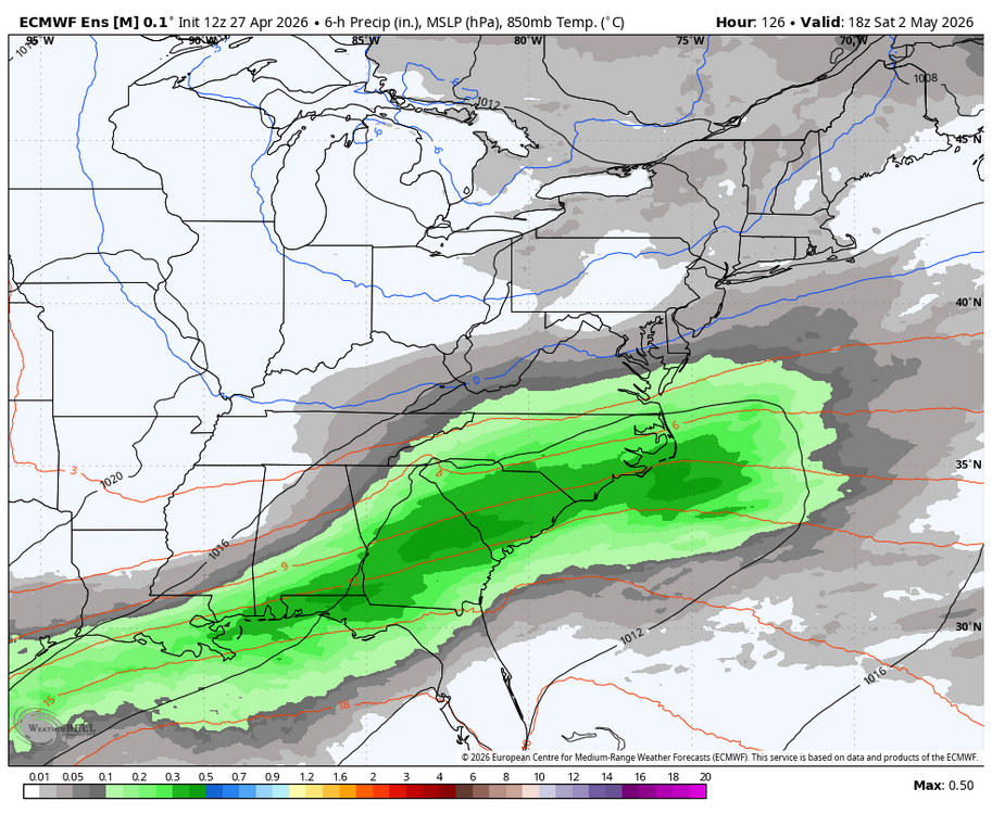
I still think the area south of ATL gets F'd again. The moisture just disappears whenever it gets close. I've seen it way too many times the last 9 mos.
-
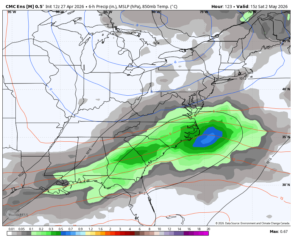
WB 12Z EPS, hug Member 48!

-
I’ve paid this zero attention - is this a mountain snow threat? Can’t help but automatically look at the 850 line on these maps.
-
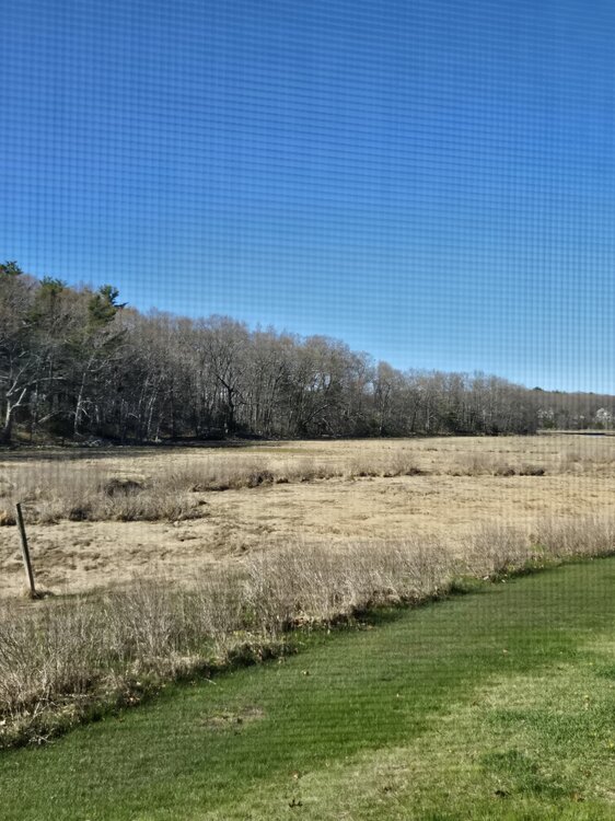
South shore of MA has yet to leaf out directly on the coast. Ita crazy how far behind we are. Today was nice. Hoping we can get out of this coastal influence we've been stuck in for weeks
-
Pollen seems to be peaking again.
-

Potential Sever Weather Outbreak 4/27/2026
andyhb replied to pen_artist's topic in Lakes/Ohio Valley
PDS tornado watch out for the area surrounding the MS/OH River confluence. 80/80 tornado probabilities. -
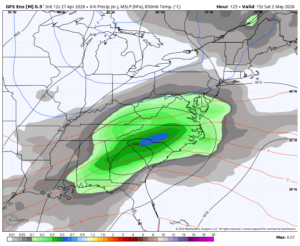
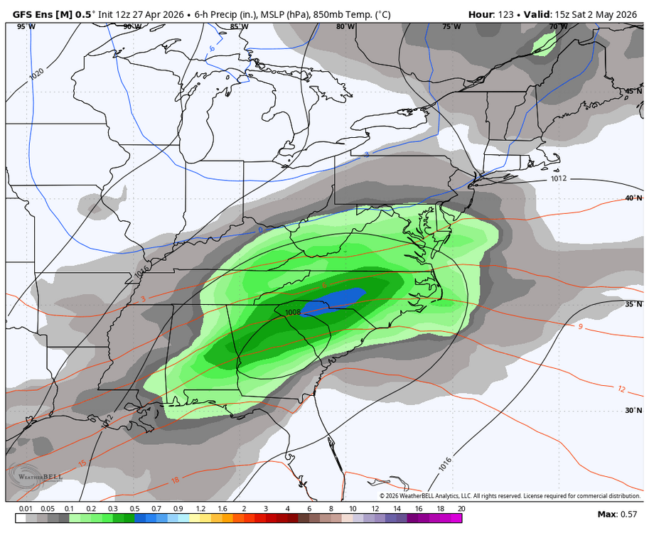
WB 12Z ensembles for Saturday.

-
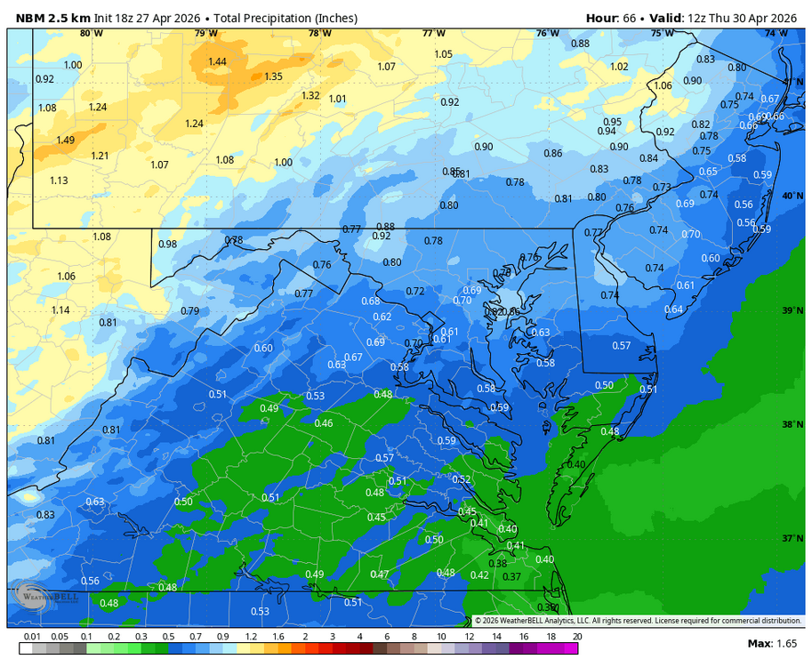
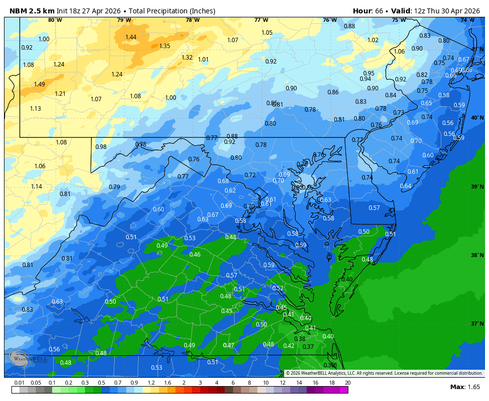
WB 18Z NBM for Wed.