All Activity
- Past hour
-

2026-2027 Record-breaking El Nino
40/70 Benchmark replied to Stormchaserchuck1's topic in Weather Forecasting and Discussion
@Stormchaserchuck1 -
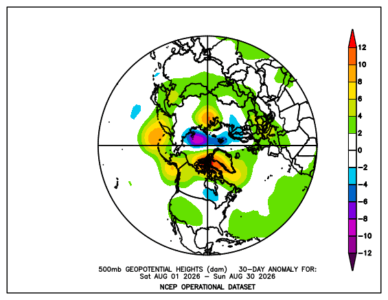
https://psl.noaa.gov/data/histdata/ Its kind of a pain vs the others but at least it is still operational.
-
Tropical Storm Edouard has been spinning around in SE Texas since yesterday afternoon. Some radar rainfall estimate pixels approaching 16-18" now. The center has been drifting NNE for the past several hours. If it continues to head more north/east than the models were showing, I may end up getting some rain later today in Longview. Tyler has a better chance though. NWS SHV has mentioned the possibility of tornadoes but it's a pretty low chance, especially since we haven't really seen any signs of that yet.
-

2026 Mid-Atlantic Severe Storm General Discussion
SolidIcewx replied to Kmlwx's topic in Mid Atlantic
A nocturnal training event would be great! -

Septorcher 2026 Discussion - Endless Summer
Typhoon Tip replied to Damage In Tolland's topic in New England
-
As mentioned in a previous post, we still need to watch that developing buzzsaw (Lowell) for a northward turn in a few days. Some of the globals have been flirting with Kauai every other operational run. It may ultimately miss to the west, but that may not be nailed down yet until we see how trough interaction evolves.
-

2026-2027 Fall/Winter Mountain Thread
Maggie Valley Steve replied to BlueRidgeFolklore's topic in Southeastern States
Looks like rain chances increase as the weekend approaches with cold front dropping down. I see GSP has dropped the possiblity for Heat Advisories outside the Mountains the rest of the work week. My high yesterday was 81. -
Been a mostly fun year, minus the absolute heartbreaks in the 8th-9th innings. Is there a world where the keep Abrams, Wood, and even Lyle at this point long term? Minors have some decent pitching options in the next few years and Cavalli has proven to be a bonified 1/1A at the head of the rotation. Would be tough as a fan to continue to keep watching good young talent just keep walking out the door.
-

Central PA Summer 2026 Discussion/Obs Thread
mahantango#1 replied to Voyager's topic in Upstate New York/Pennsylvania
-
ready 2 mild
-
LWX AFD from this morning does also state severe storms are possible well into the night KEY MESSAGE 1...Daily severe weather threat through the end of the week. Multiple rounds of thunderstorms, some likely severe with damaging winds, are likely today through Friday as upper level disturbances move from the Great Lks into the Mid Atlantic states. Already seen a small cluster of thunderstorms over south central Pennsylvania that will move through the area later this morning. Two additional rounds of thunderstorms seem likely today, one this afternoon, and a second one late this evening into the overnight hours tonight into Thursday. Thunderstorms will ride southeast along and north of a backdoor front currently pushing south through northern VA and southern MD as seen on TDWRs and wind shifts to the NE at IAD and DCA a couple of hours ago. The severe threat will not be necessarily tied to the afternoon and evening hours as record warm nighttime temperatures and high humidity yield strong instability and keep thunderstorms going strong well into the overnight hours. By Friday, cold front should have cleared much of the forecast area causing a stabilizing effect limiting the risk of severe weather, but showers and thunderstorms will still be possible north of the sfc front.
- 2,298 replies
-
- 1
-

-
- severe
- thunderstorms
- (and 7 more)
-
1300z SPC OTLK disco says the morning convection is causing question marks for later Day 1 Convective Outlook NWS Storm Prediction Center Norman OK 0723 AM CDT Wed Sep 02 2026 Valid 021300Z - 031200Z ...THERE IS A SLIGHT RISK OF SEVERE THUNDERSTORMS OVER PORTIONS OF THE NORTHEAST STATES...AND ACROSS PARTS OF MONTANA... ...SUMMARY... Severe thunderstorms are possible across portions of the eastern Great Lakes to the Mid-Atlantic today and tonight. Damaging wind gusts are the main threat, though some large hail and a few tornadoes may also occur. Scattered severe gusts and more sporadic occurrences of large hail appear possible from the northern Rockies into northern High Plains today into night. ...Northeast States... A complex but potentially active convective day is in store for parts of the northeast US today. A fast-moving MCS and associated mid-level shortwave trough is over Lake Michigan. This system is forecast to track rapidly eastward across Lower MI and southwest ON this morning before emerging into western NY/PA this afternoon. A consensus of overnight CAM solutions indicate this will be the focus for strong-severe thunderstorms that track east-southeastward during the afternoon and evening toward the Mid-Atlantic coast. Ample low-level moisture is present in this corridor. This along with daytime heating well into the 80s and steep low-level lapse rates will favor damaging wind gust potential in the strongest storms. A north-south surface boundary is expected to lie from central NY into east-central PA this afternoon, where low-level shear will be locally enhanced to pose some risk of a few tornadoes. The primary uncertainty for a more widespread severe event today is the presence of considerable morning convection currently over northwest PA and western NY. These storms are well-ahead of the main forcing feature, and decrease confidence in significant destabilization over the primary risk area this afternoon. These early storms may pose a damaging wind and hail risk through the day, especially after a few hours of heating.
-
@CAPEthis humidity is different lol
-
The HRDPS reflectively did pretty good on the 06z and 12Z runs yesterday with storms over central PA yesterday extending SE, and the most current SPC storm reports (from yesterday). Today's HRDPS 6z seems to do ok thus far, but the southern storm complex (modelled) is a little farther north. Still doing better than most of the other short-term modeling. Thought I would chime in, since I have family in NY, friends in PA, and was watching the evolution yesterday and providing some short-term forecasts. Like all the discussions.
- 2,298 replies
-
- 1
-

-
- severe
- thunderstorms
- (and 7 more)
-
Edouard's structure remains quite impressive this late AM. It doesn't appear these deep convective bands are going to let up anytime soon. It's no surprise that the rain totals are beginning to lead to flash flood emergencies.
-
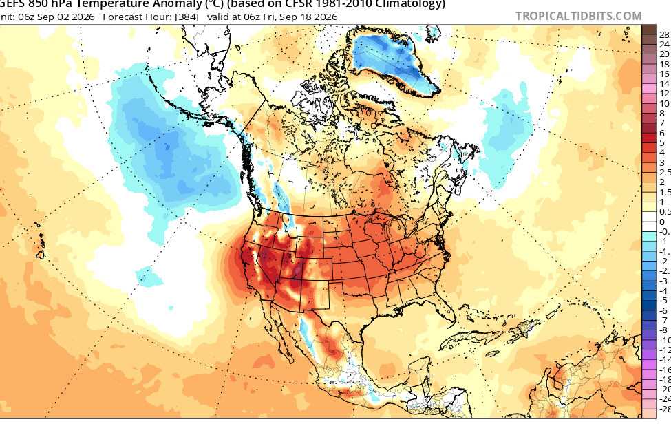
There’s something wrong with a lot of their 1981-2010 2m climo during the winter months around the Great Lakes. Almost like they’re using Lake Superior water temps in the grids so that there’s always a large, permanent negative 2m anomaly there.
-
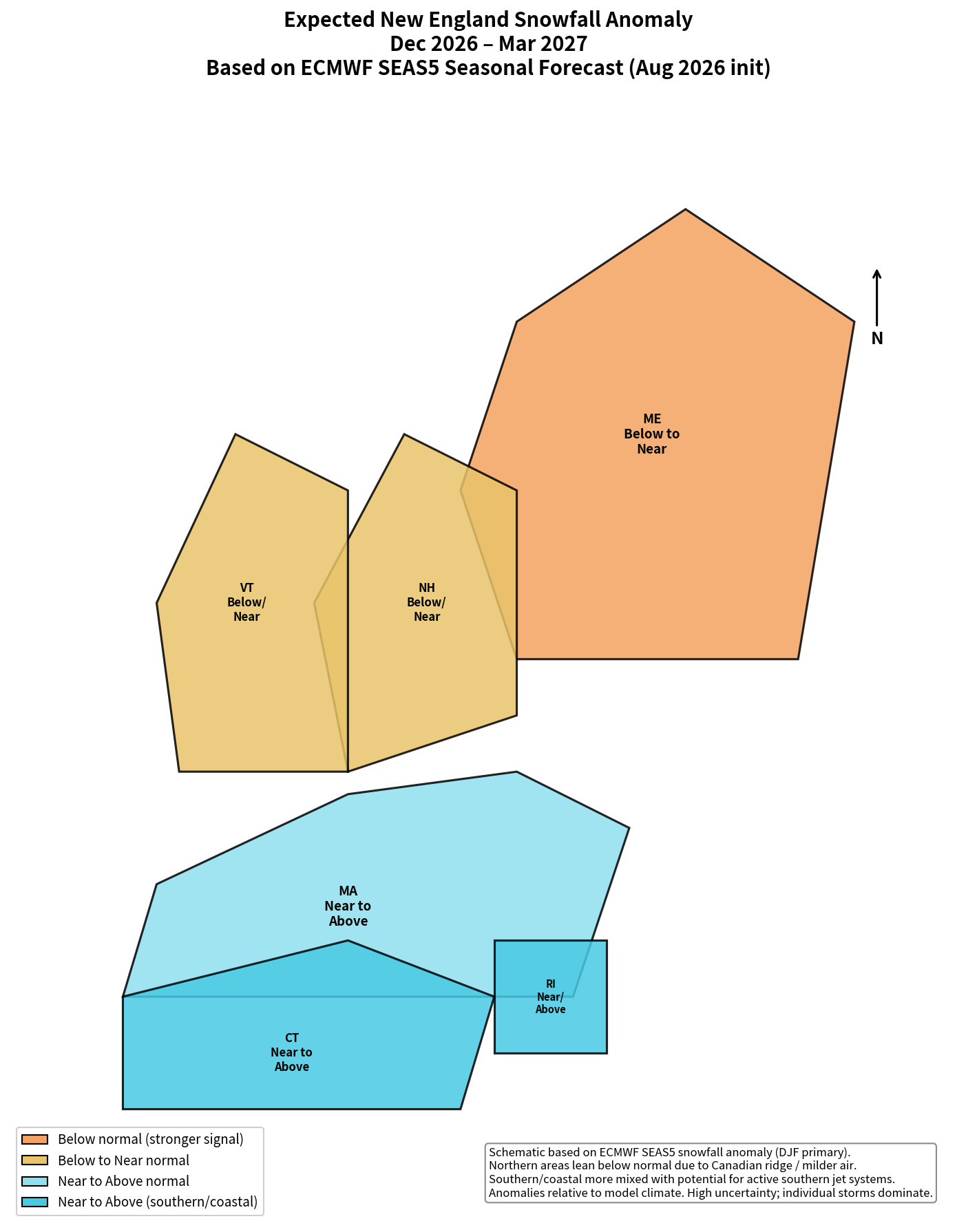
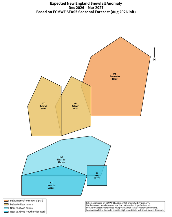
Grok based on the ECMWF seasonal
-

Septorcher 2026 Discussion - Endless Summer
CoastalWx replied to Damage In Tolland's topic in New England
It’s amazing, everyone getting fun and damaging weather except New England. Another big SVR day from NYC to DE last evening. Unreal. -
Septorcher 2026 Discussion - Endless Summer
CoastalWx replied to Damage In Tolland's topic in New England
Why can’t we get that? -
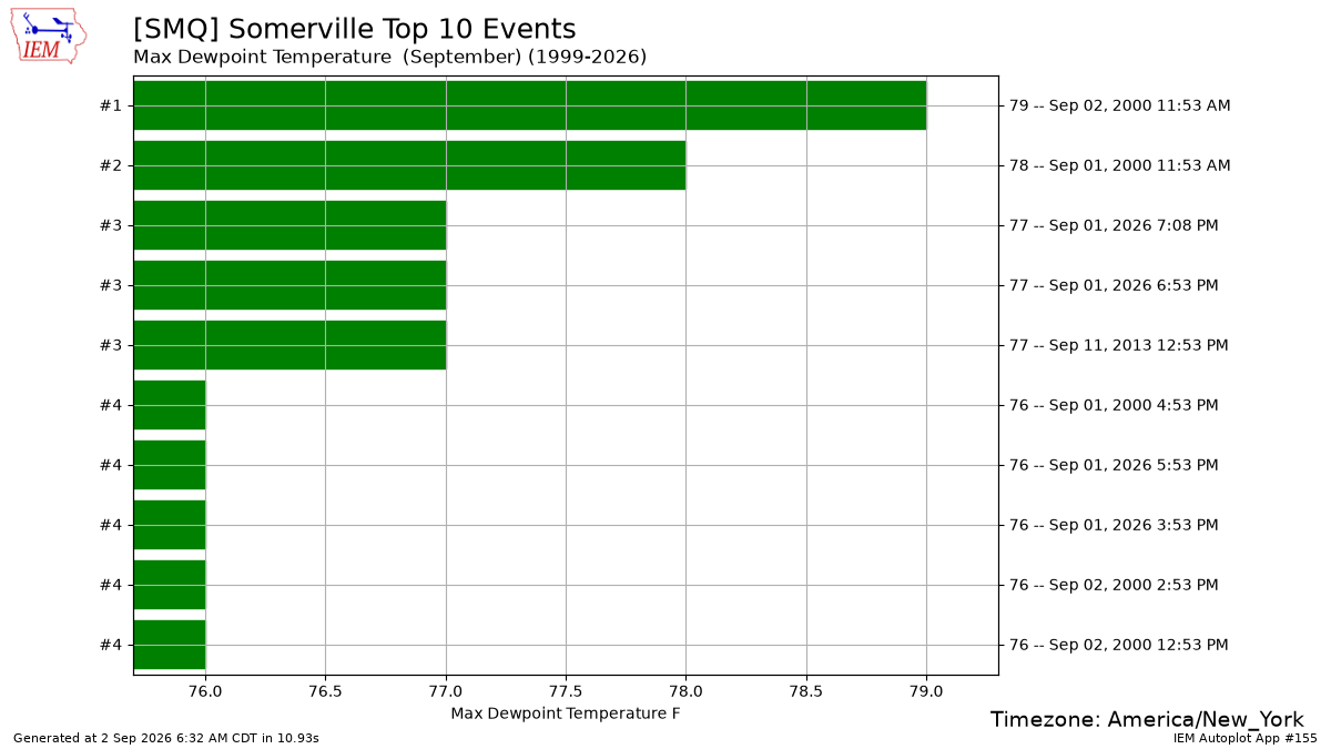
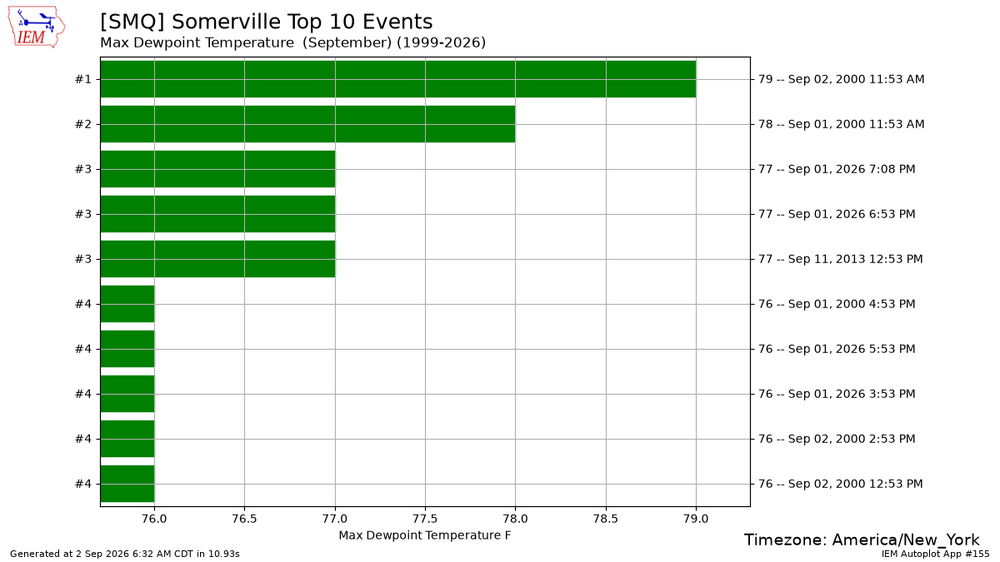
SMQ approached their all-time highest September dewpoint yesterday at 77°. CITY SKY/WX TMP DP RH WIND PRES REMARKS Newark/Liberty TSTM 77 72 84 E5 29.93R Teterboro TSTM 76 73 91 E7 29.94R Caldwell TSTM 76 75 97 NW9 29.96R FOG Somerville LGT RAIN 79 77 94 N3 29.91R FOG Linden CLOUDY 78 72 80 SE8 29.94R Perth Amboy N/A 75 N/A N/A E6G13 N/A Sussex NOT AVBL Andover N/A 79 73 82 E3 29.96R Trenton MOCLDY 84 75 74 CALM 29.92S HX 92 Millville N/A 84 76 76 CALM 29.93F HX 93 Atlantic City PTCLDY 88 75 65 SW9 29.94S HX 97 Wrightstown MOCLDY 84 75 74 S3 29.92R THUNDER HX 92 Toms River PTCLDY 81 75 82 S3 29.94S
-
Highs: EWR: 105 (1953) NYC: 102 (1953) LGA: 102 (1953) JFK: 93 (1973) Lows: EWR: 49 (2017) NYC: 51 (1886) LGA: 56 (2017) JFK: 53 (1949) Historical: 1775: The Independence Hurricane This savage hurricane raged from North Carolina to Newfoundland. Heavy rains began to fall across the colony on the 29th of August and slowly increased with time. The coast was ravaged from Currituck to Chincoteague. Wharves and storehouses on the waterfront of Norfolk were devastated. Bridges were carried away by the raging waters. At Williamsburg, mill dams broke and corn stalks were blown flat. Winds blew furiously until 10:00 p.m. Many ships were damaged as they were thrown ashore at Norfolk, Hampton, and York. Around twenty-five vessels were run ashore, or "irrecoverable gone." The gun ship H.M.S. Mercury was driven hard aground on Portsmouth Point at 5:00 p.m. on the 2nd. It was stranded in two feet of water for eight days (Shomette). The Liberty became "hopelessly stranded" in Back River, near Hampton. A number of locals boarded her, captured the crew, secured her goods, and set the ship afire in the first outright act of war. A full blockade of Hampton Roads thereafter brought shipping to a halt for three months. At least twenty-five died due to shipwreck.(Ref. The Independence Hurricane) 1882: Possibly the first photograph of a lightning strike was taken on this day by William Jennings in Philadelphia, Pennsylvania. 1887: The U.S. Army Signal Service station in Greenville, SC reported a minimum temperature of 50°F. This observation at Greenville still stands as the record low for the day. Additional stations across the state recorded low temps in the low 50's. 1935 - Perhaps the most intense hurricane ever to hit the U.S. struck the Florida Keys with 200 mph winds. The hurricane produced a fifteen foot tide and waves thirty feet high. 400 persons perished in the storm on that Labor Day. The barometric pressure at Matecumbe Bay FL hits a record low for the U.S. of 26.35 inches. (David Ludlum) 1950 - The temperature at Mecca, CA, soared to 126 degrees to establish a U.S. record for the month of September. The low that morning was 89 degrees. (The Weather Channel) 1950: The temperature at Mecca, CA soared to 126 degrees to establish a U.S. record for the month of September. The low that morning was 89 degrees. (The Weather Channel) (Ref. WxDoctor) (Ref. AccWeather Weather History) 1953: Boston, Massachusetts had 100 °F for the second time ever in September. Chicago, IL hit 101° for the second day in a row and the tenth of 11 consecutive days with a high temperature at 90° or higher. (Ref. NOAA Boston Weather Events) 1961: Denver, CO picked up 4.2 inches of snow, the earliest measurable snow for the Mile High City. (Ref. AccWeather Weather History) 1982: A wind gust of 121 mph was reported at the Chautauqua County Airport near Jamestown, NY causing an estimated half million dollars in damages to the terminal building, planes, cars and landing instruments. Rainfall totals exceeded two inches in places. (Ref. Wilson Wx. History) 1985 1985 - After teasing residents along the Gulf of Mexico for two days, Hurricane Elena finally came ashore at Biloxi MS. The hurricane, packing winds of 127 mph, caused more than a billion dollars damage. (The Weather Channel) 1987 - Late evening thunderstorms in the Northern Plains Region produced wind gusts to 75 mph at Jordan MT, and a ""hot flash"" at Redig SD. The temperature at Redig rose from 66 degrees at 10 PM to 86 degrees at 11 PM as thunderstorm winds gusted to 36 mph. Nine cities in the Upper Ohio Valley, the Tennessee Valley and the Central Gulf Coast States reported record low temperatures for the date, including Elkins WV with a reading of 38 degrees. (The National Weather Summary) (Storm Data) 1988 - Unseasonably hot weather prevailed in the northwestern U.S. Afternoon highs of 98 degrees at Olympia WA, 98 degrees at Seattle WA, 105 degrees at Portland OR, and 110 degrees at Medford OR, established records for the month of September. Quillayute WA equalled their September record with an afternoon high of 97 degrees. (The National Weather Summary) 1989 - Eight cities in the Gulf Coast Region reported record high temperatures for the date as readings soared into the upper 90s. Houston TX and Port Arthur TX hit 99 degrees. Late evening thunderstorms, developing ahead of a cold front, produced wind gusts to 63 mph at Dickinson ND, and golf ball size hail in North Dakota and Nebraska. Winds along the cold front itself gusted to 62 mph at Buffalo SD. (The National Weather Summary) (Storm Data) 1996: After teasing the entire Atlantic coast with winds as high as 140 mph, Hurricane Edouard skirted New England without making landfall. Hurricane force winds were recorded on Nantucket and Cape Cod, but wind damage was relatively minor. 1996: Large swells from Hurricane Fran knocked five people out of an 18-foot fishing boat in Jupiter Inlet, FL. The Coast Guard rescued all five people. (Ref. Wilson Wx. History) 2002: An F3 tornado roared into downtown Ladysmith, WI at mid-afternoon, heavily damaging 64 blocks of the business district. Fortunately, it was Labor Day, and most of the stores were closed for the holiday or the toll would have been much worse. The National Weather Service came under fire for not issuing a tornado warning before the storm struck. (Ref. Wilson Wx. History) 2003: Indianapolis, IN was drenched with 7.20 inches of rain on this date for its greatest single day rainfall on record. (Ref. WxDoctor) 2006: Tropical Storm Ernesto dumped 8.93 inches of rain on Norfolk, VA for the city's greatest single day rainfall on record. (Ref. Wilson Wx. History) (Sep. 1st-2nd) Heavy rains from the remnants of Tropical Storm Ernesto fell on SE PA. In Schwenksville, a man jumped into an overflowing retention basin to try to rescue his dog. The dog was sucked into and through the outflow pipe and survived; his master drowned. (Ref. Weather Guide Calendar with Phenomenal Weather Events 2011 Accord Pub. 2010, USA) 2008: Northeastern Illinois: In Chicago the thermometer at O'Hare IAP hits 94°F (34.4°C), and Midway tops out at 95°F (35°C), the first such high there in 761 days, and the warmest day of the year Kankakee, New Lennox, Plainfield and Palatine (my home town hit 97°F. (Ref. WxDoctor) 2002: An F3 tornado destroyed much of the downtown area of Ladysmith, Wisconsin. Overall damage was estimated at $20 million, but there were no fatalities.
-
Yeah just surpassed 1991 with the largest discrepency between EWR / PHL with PHL having 14 more. EWR does have the 6 89 degree days PHL only 2.
-
69 / 67 clouds NE flow. Ugly day sun about an hour to 90 min drive in PA and SNJ otherwise socked in the marine layer and some drizzle at times. Flow comes around Thu/Fri and could see some overperforming high Thursday warm / hot spots touch 90 inland otheriwse mid-upper 80s. Clouds and showers Friday keep it into the 80s for most. Onshore flow keeps the long labor day weekend neaer normal and hopefully dry - a california-ish feel. Beyond there warms up a bit and back and forth progressing towards and overall warm / above normal by the mid month period where trough into the WC could push ec ridge.
-
We were in Ocean City mid August-it was great outside of the lack of waves due to no storms in the Atlantic.
- Today
-
Got multiple tornado warnings and severe warnings but no watch up there.