All Activity
- Past hour
-
-
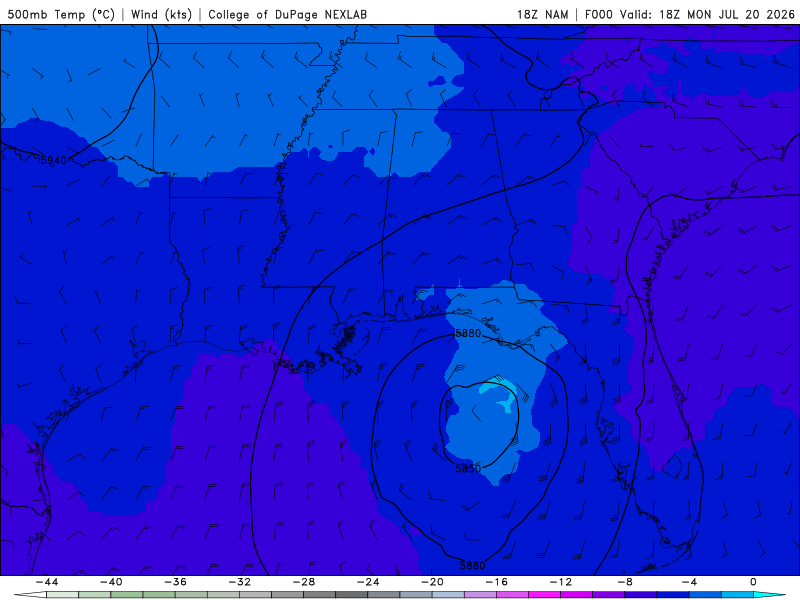
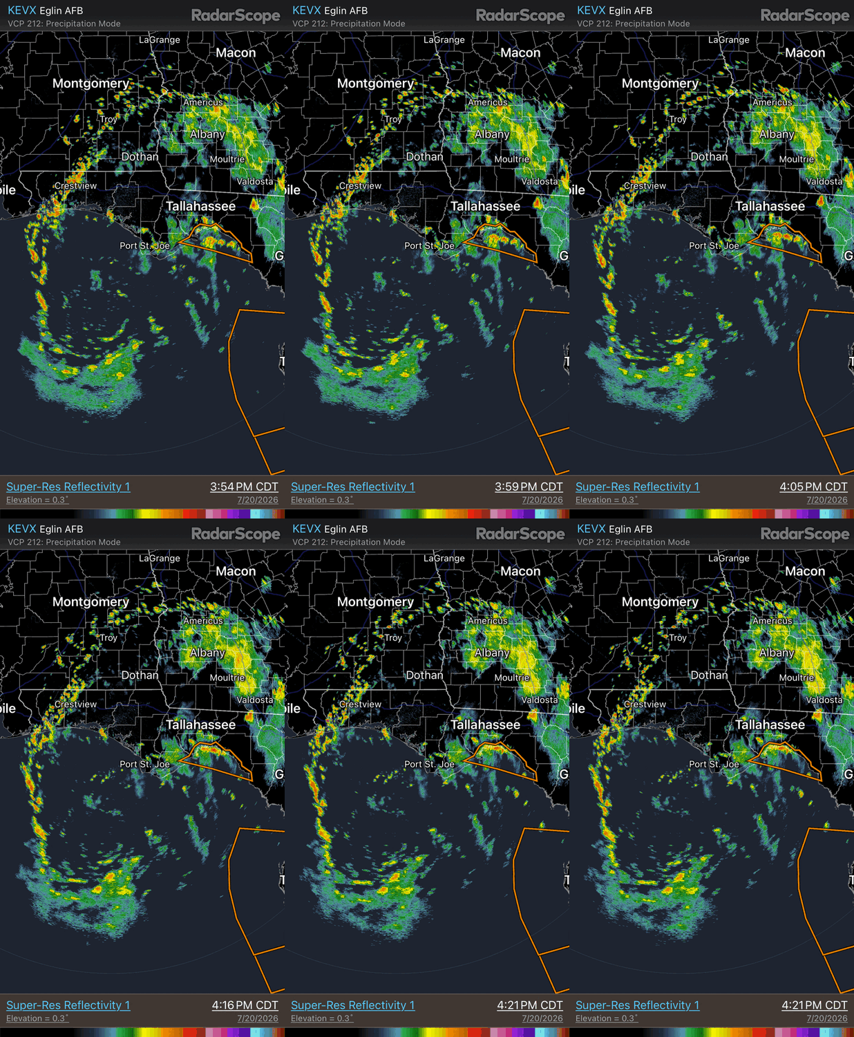
It became more warm core faster than expected. 500 analysis 18z NAM shows warm core at 500 w/ temps to -2 C (attached). HRRR the other day showed the gradual organization well and the broad skeletal structure w/ the banding. See radar loop attached. Being so broad and dry air issues, it likely going to have problem tightening up, and by 36 hr, the ECWMF shows the 500 low getting sheared apart from deformation. GFS does not show this nearly as much, but I trust the ECMWF more there. Also the GDPS is similar to the ECMWF. The LLCC looks to eventually accelerates W after its gets to the LA cost, which is generally not good (too much shear) for a weak system in in tropical easterly flow. Sharp asymmetry fcst w/ all the heavy rain sheared to the S of the LLCC. Just an empirical observation over time, NHC seems to intensity too quickly nascent systems that are broad and not in the best overall environment In the first advisory ydy at 15z, they had it a 35 kt TS by 12z today. Second advisory 35 kt TS by 18z today.
-
Seeing real blue again
-
This had a reported tornado near Webster City, Iowa (continuing tornado warning)
-
1.22" from this afternoon. Forecast highs in the 70's on Thursday? I'll believe it when I see it ...
-
temp/dew point of 100/50 at Fort Collins/Loveland (KFNL) so that's a 50% relative humidity, right Nope. 200% relative humidity?? 103 at Greeley right now. Be glad you don't have dew points like Nebraska today, which has a heat index of 110 a few 101s yesterday near Loveland and Denver
-

2026-2027 Super El Nino
Stormchaserchuck1 replied to Stormchaserchuck1's topic in Weather Forecasting and Discussion
IRI model consensus of +3.05c would make it the Strongest El Nino on record since 1950 by +0.25c (NDJ 15-16, +2.8c) [ONI]. Number 2 is +2.4c (ONDJ 97-98), which it would beat by more than 20%! Since 1950, there has never been a La Nina <-2.0c. -
That MCS just took the smoke away.
-
1.41” at my house between 3 separate periods of rainfall brings the MTD total to 7.98”
-
Just under 2 inches IMBY in Garner this afternoon
-
Oh I bet! That spot is always horrible. Here is the roll cloud I caught: https://www.facebook.com/share/v/1CwggxCZbM/ - Video
-

Central PA Summer 2026 Discussion/Obs Thread
canderson replied to Voyager's topic in Upstate New York/Pennsylvania
I used to not be but am growing more the same - especially since storms are more severe now than before. -
I’m going to be in the theater watching odyssey tomorrow evening when my roof gets torn off in the derecho
-
This is my moment
-

Central PA Summer 2026 Discussion/Obs Thread
Voyager replied to Voyager's topic in Upstate New York/Pennsylvania
Sure is quiet in here (and in the Pittsburgh sub) considering the severe threat tomorrow. -
Josh and I once experienced a tor warned cell from the concourse during a cubs tigers game
-
I wouldnt call it plug and chug nonsense even if there is disagreement with the approach. The ability to train models on a boatload of historical and real time data is going to improve accuracy over time. But you dont entirely lose the human element. AI isn't going anywhere....we're behind industry for sure, but fed agencies are quickly adopting AI for a lot.
- Today
-
 I was on eastern Long Island the weekend before last and they got absolutely rocked with severe on the 4th of July. Damage in every yard, with multiple measured gusts of 87. I saw Hartford (edit Bristol) got 3" hail that day too. Better than anything I've seen nearby this spring. BTown has been hit a few times too as usual. Anyway I'm still involved in running the UMass radar and following wx back there closely.
 -
That small rain storm put down .95 in less than 20 minutes. It was some if the hardest rain I've seen in a while.
-
Bad street flooding right now around Glenwood/440 on my commute
-
WRONG! I guess my information was bad, this puts us in 3rd place. The record is 14 days in 1936, followed by 11 days in 1948. There was a logjam at 3rd place but 2026 will now hold the spot.
-
Decent evening on tap with sunny and 83/64 right now. While I don't expect much if any rain from the front, it's looking like some great weather Thursday through the weekend with upper 70s/low 80s and bright sunshine. Gimme that!
-
And nam is mostly Wednesday morning
-
Caught a nice roll cloud before the bottom dropped out here.
-

2026 Mid-Atlantic Severe Storm General Discussion
SolidIcewx replied to Kmlwx's topic in Mid Atlantic
Unless the “storm cluster” is coming right at me and within 10 miles im not gonna get my hopes up. I understand the frustration when it comes to severe weather in this area since moving here last year