All Activity
- Past hour
-
Another day of crazy winds
-
Fixed your post. You're welcome
-

Central PA Winter 25/26 Discussion and Obs
Itstrainingtime replied to MAG5035's topic in Upstate New York/Pennsylvania
My Orioles and Phillies tickets were uploaded to my MLB Ballpark App last week. Let's go! We better enjoy this season... -
Almost all models have a little refresher for late tonight and early tomorrow. Anywhere from 0.5" - 2.0" seems likely for most. Obs here.
-
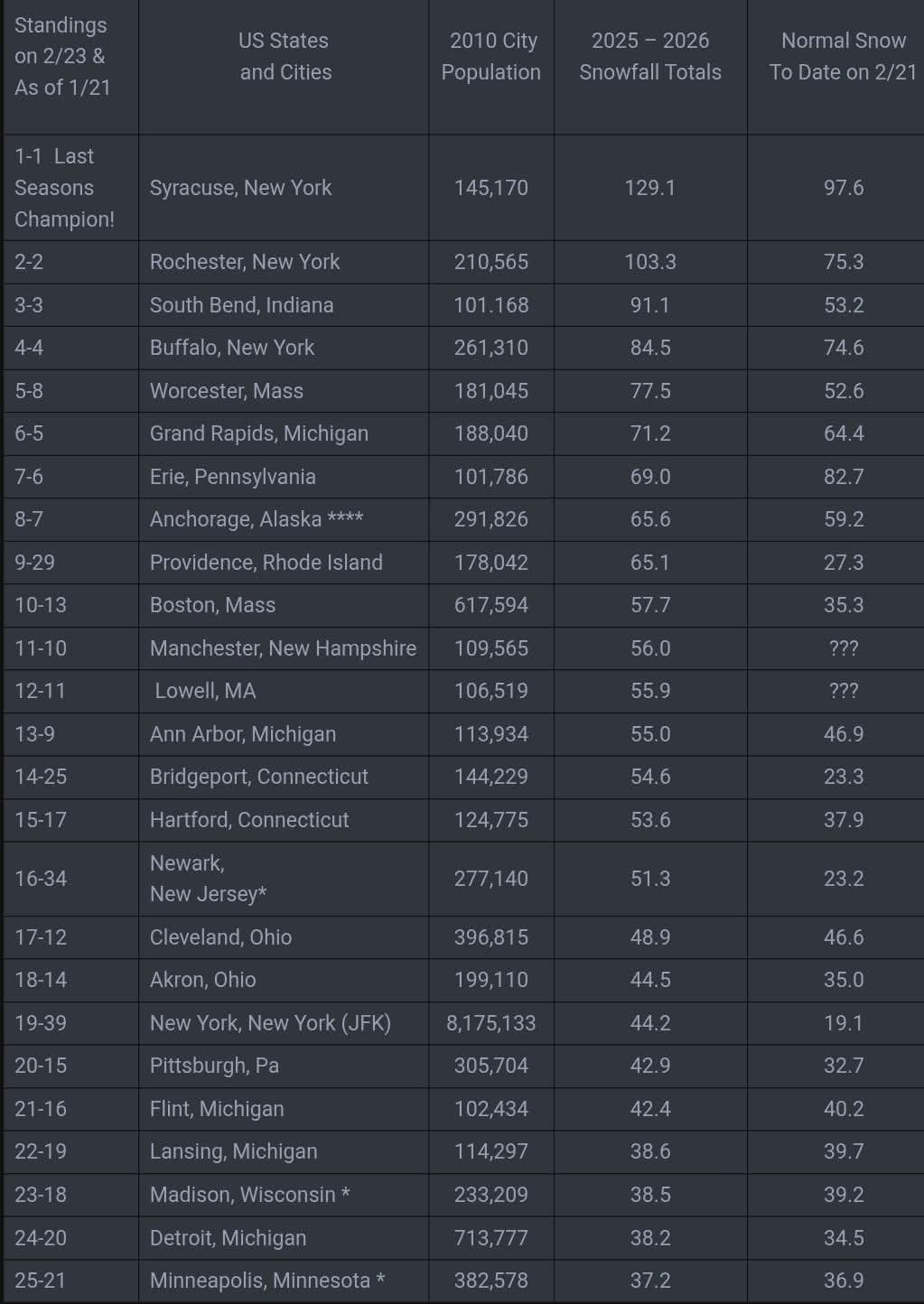
14" in Trumbull. To paraphrase Frank Costanza at the airing of grievances, "I have a lot of problems with the way snow is measured these days". Let's look at BDR: On 2/22 they recorded 5", but never more than 2" on the ground. What? On 2/23 they recorded 15" with 18" on the ground. So, tons of settling on the 22cnd, but none under a load of snow on the 23rd? Also, they show 1.5" LE on the 23rd to match the 15" of snow. This reeks of "I don't feel like going out and measuring, let's just use 10:1 and call it 15". As my kids used to say, "we call shenanigans". They called it shenanigans; I call it bullshit.
-

2025-2026 ENSO
PhiEaglesfan712 replied to 40/70 Benchmark's topic in Weather Forecasting and Discussion
I knew I should have stuck to my gut and kept 2013-14 as a top analog. We were in a solar max/-PDO heading towards neutral/2nd year near neutral ENSO. -
Did TF Green not get anymore snow after 7pm yesterday. That is the last report I can find for them.
-
13” in Southington. South central part of town.
-
I may be incorrect however I feel like whenever we torch in March we have a horrific cold and rainy April (well more than usual).
-
Even yesterdays 36 degrees mushafied some areas. We'll see if the 3/3 storm adds to this
-

E PA/NJ/DE Winter 2025-26 Obs/Discussion
MJO812 replied to LVblizzard's topic in Philadelphia Region
Thats our last shot for the winter. -

-
Boston gets 18 again
-
I’m down for as much snow as possible before March 8th. But then let’s torch!
-
Hopefully we can squeeze in one more historic blizzard before the pattern flips. Unfortunately looks like we hit phase 8 by mid to late March just in time to ruin spring.
-
-

Central PA Winter 25/26 Discussion and Obs
Mount Joy Snowman replied to MAG5035's topic in Upstate New York/Pennsylvania
The monthly, seasonal, and annual climate summary reports for the official stations roughly sum things up. See below for an example from January's report. SKY COVER POSSIBLE SUNSHINE (PERCENT) MM AVERAGE SKY COVER 0.62 NUMBER OF DAYS FAIR 4 NUMBER OF DAYS PC 16 NUMBER OF DAYS CLOUDY 11 AVERAGE RH (PERCENT) 63 WEATHER CONDITIONS. NUMBER OF DAYS WITH THUNDERSTORM 0 MIXED PRECIP 0 HEAVY RAIN 0 RAIN 1 LIGHT RAIN 5 FREEZING RAIN 0 LT FREEZING RAIN 1 HAIL 0 HEAVY SNOW 2 SNOW 4 LIGHT SNOW 7 SLEET 2 FOG 13 FOG W/VIS <= 1/4 MILE 4 HAZE 3 -
There’s a 3-4 week lag effect generally
-
I had 3” during the day yesterday and a little over an inch more overnight. My total since Saturday night came out to 8.4”. In terms of counties needing warnings, it was really close in a few. The upslope definitely was more impressive than expected. The tricky aspect is the storm totals are impressive, but occurred between Saturday night and early Tuesday morning which is a very long duration. The heaviest snow was during the day yesterday and it was struggling to consistently cover main roads due to the higher sun angle for several hours. Still, some areas got over 8” and a <24 hour span which is getting to the point where it’s hard to look the other way. I’ll be looking closely at Medina and Geauga in particular…a few spots in Cuyahoga, Summit, and Erie Co PA were close to that as well, but Medina and Geauga seem most impressive overall.
-
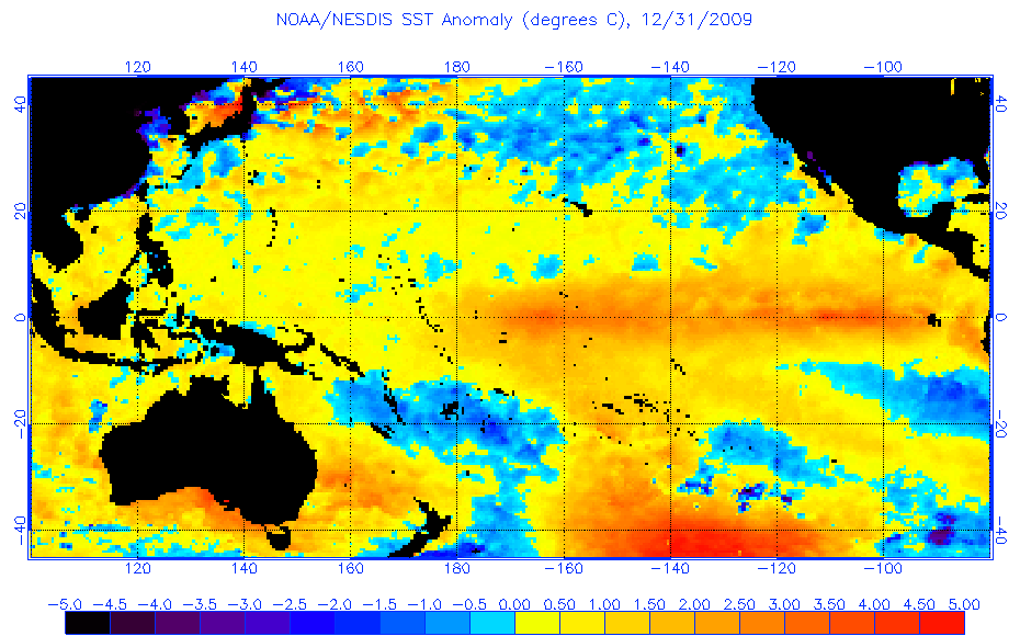
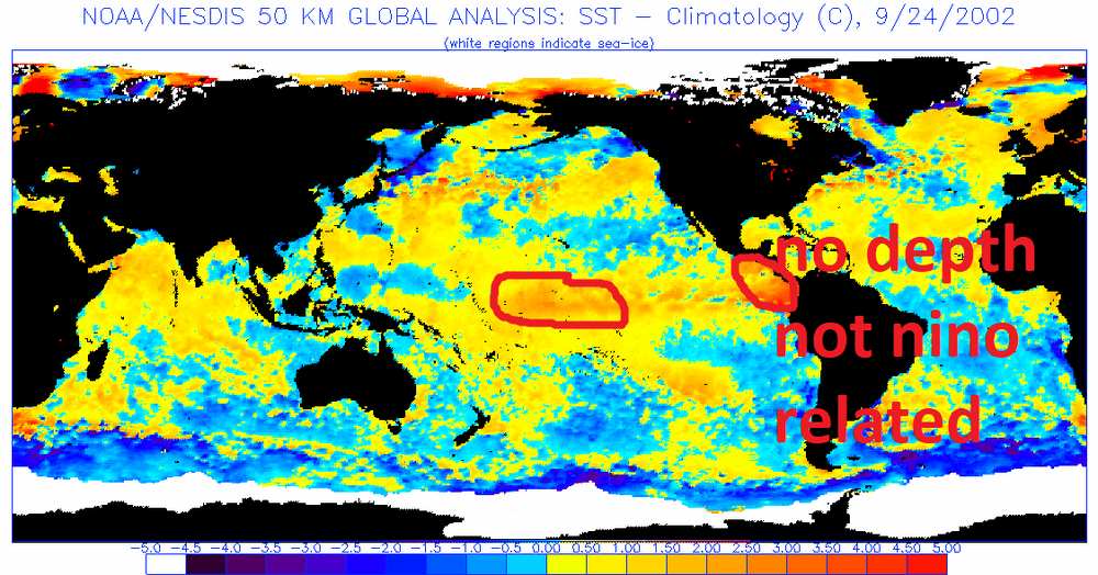
A couple of things I've noted when looking at SST's leading into all our Ninos and our snowfall results. How the Nino starts has more impact than how it ends, unfortunately. A true Modoki starts out west based (which is rare, most start east and evolve west but those don't have as much positive impact on our snowfall as ones that start and stay west based) I think a true Modoki is unlikely at this time. 2002/3 was a perfect classic example of a Modoki nino If you ignore the anomalies right along the central america coast which were not completely related to the nino, those would actually have been slightly SW of there in a true east based nino, the core of the warmest anomalies at the inception of the nino in September 2002 was clearly out near the dateline. A true Modoki. But a basin wide representation ups our chances of a truly massive snowfall over an east based. The strength matters. The best seems to be a moderate basin wide. 2010 fell into this category. If a basin wide goes strong it becomes like 1983 and 2016, much warmer but still with an increased chance of a massive storm if we can just time one STJ wave up with just a cold enough airmass. Basin wide events actually have the highest correlation with HECS storms! Below is how I would categorize the different options. I am only categorizing moderate to strong here because weak ninos are a wildcard. IF they gain the necessary strength to impact the pattern they act like a moderate. If they do not, the winter tends to behave more like an enso neutral. Somewhere between weak and moderate is a tipping point where a nino actually behaves like we think of as nino. But let's assume this next event is strong enough to reach that threshold...then the chart below is what I've noted looking at all our enso events From best to worst although this is subjective True Modoki Event strong or moderate: the strentgh of a true modoki doesn't seem to matter as much, but a true modoki event has never attained super nino status, they seem to cap at borderline moderate/strong. A true modoki typically ends up more EPO driven than NAO, colder, more moderate snow threats, but with more events due to the enhanced STJ. Moderate basin wide: Our best chance at a HECS storm AND a colder nino if we get the NAO to cooperate. 2010 is the perfect example of when this type goes right Strong basin wide: elevated chance of a HECS but overall a warm winter is likely, Think 1983 and 2016 moderate east based: These tend to be somewhat warm winters but have produced some snowy periods if we can get cold for a few weeks with the enhanced STJ but overall they average out to slightly below avg snowfall for Baltimore Strong East based: disaster, they are wall to wall torch winters, think 1998
-

Feb 22nd/23rd "There's no way..." Obs Thread
PrinceFrederickWx replied to Maestrobjwa's topic in Mid Atlantic
I'm moving soon so I don't care, but LWX using 6.0" from State Highway in Prince Frederick is bonkers as usual. -

Clipper Fires In Wednesday Feb 25 Disco/ Obs
Sey-Mour Snow replied to Damage In Tolland's topic in New England
No doubt definitely 45-50 potential in the normal torch spots after the snow . Most guidance is 40-45 tomorrow across SNE not including the colder elevations., -
Yeah yesterday was impressively cold.
-

Clipper Fires In Wednesday Feb 25 Disco/ Obs
weatherwiz replied to Damage In Tolland's topic in New England
I actually wouldn't be surprised if the degree of warming temps is a bit understated, especially during the precip. Possible maybe we see some late afternoon highs? -

Central PA Winter 25/26 Discussion and Obs
Superstorm replied to MAG5035's topic in Upstate New York/Pennsylvania
Agree. After that last storm, seeing anything else that’s not going to have staying power is useless. Unless you’re looking to pat the stats. I’m already geared up for baseball! .