All Activity
- Past hour
-

1/24-1/25 Major Winter Storm - S. IL, IN, and OH
Stevo6899 replied to A-L-E-K's topic in Lakes/Ohio Valley
The low on the coast is forming, stealing some of the northern energy from the main low that still hasn't made it out of northern bama. This storm is another example why detroit struggles to get big dogs. You get a low trying to take a favorable track but coastal steals energy. Its pretty cool to see the whole state of PA covered in heavy green returns. -
Still kind of a somber vibe in here, so I’ll focus on the silver lining. I know there’s several hours of storm left, but it looks like Richmond may have escaped a pretty significant ice storm thus far. Roads will still be tricky for a few days, given the cold temps. But the trees and power lines seem okay so far. Hopefully we can hold onto power (and by extension, water). .
-
Went on my Jeb walk. The sleet is impressive. Coming from the Great Lakes area ive never seen sleet like this and at such low temps. Climo here is very intriguing to say the least.
-
 Coastal now developing off HAT.
 -
That's probably around what I got here. I don't measure until 11:40am.. Yes. I know probably OCD. LOL
-

January 25-26 Winter Storm Potential
CoolHandMike replied to Ralph Wiggum's topic in Philadelphia Region
7" here, still really fine and starting to blow around a bit. Still 9°F. -

January 24-26: Miracle or Mirage JV/Banter Thread!
Maestrobjwa replied to SnowenOutThere's topic in Mid Atlantic
Well this is a new one....someone just came up and stole the only shovel with the bend in it (and the only one with a metal end) right off my porch. Neighbor just told me and I didn't see it...thanks a lot Mr. Thief. As if I wasn't gonna have a hard enough time shoveling!!! Maybe keeping a shovel out on the porch isn't a good idea but all these years they've been out there with no issue. Unbelievable -

Extreme Cold, Snow & Sleet: SECS 1/24 - 1/26
mikem81 replied to TriPol's topic in New York City Metro
Maybe I’m looking at wrong map on COD but it seems to be advancing on the Philly radar using the sleet correlation mode -
Like the mid-Atl board earlier this morning, the Philly board is now reporting that the NAM did best with mixing line/timing.
-
It usually moves in waves. Advances north, gets beaten back a bit, then surges north quicker and further north.
-
 Gotta be 2-3" per right now.
 -

January 24-26: Miracle or Mirage JV/Banter Thread!
North Balti Zen replied to SnowenOutThere's topic in Mid Atlantic
Yup! just such a great way to break the snow lid. Hoping winter storms remember where we are now… -

Central PA Winter 25/26 Discussion and Obs
mitchnick replied to MAG5035's topic in Upstate New York/Pennsylvania
With the snow so light, I'm thinking the weight will just compact it. So unless I'm willing to clear a board and do it legit, which I'm not, the total snowfall in the yard and unshoveled walkways will end as it was when the sleet showed up. Just a hunch. -

Pittsburgh/Western PA WINTER ‘25/‘26
Rd9108 replied to Burghblizz's topic in Upstate New York/Pennsylvania
From the other met. Any mix keeps having a hard time getting NE of central Washington for the time being. @Rdd9108 @PaulTarsus we most likely stay all snow with this. -

Pittsburgh/Western PA WINTER ‘25/‘26
MikeB_01 replied to Burghblizz's topic in Upstate New York/Pennsylvania
if you are trying to use the radar out of KPIT you will see lighter precip because of the distance. If you use a composite, there is plenty of snow falling in Zanesville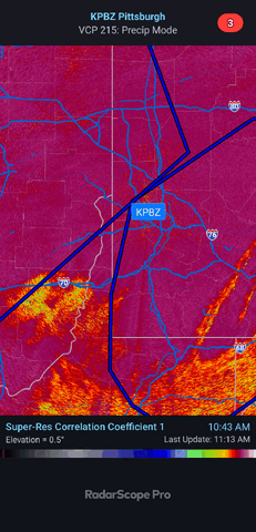
-
 Back to ZR again,CF passed through Mid Tn back down to 31 now
- 514 replies
-
- 1
-

-
- observations
- obs thread
- (and 1 more)
-
National Weather Service Greenville-Spartanburg SC 944 AM EST Sun Jan 25 2026 .WHAT HAS CHANGED... Lowered temps in the CAD and warmed them along the TN border. Kept the timing of precip changes basically the same. Storm totals are now additional amounts expected through the afternoon. Precip has mostly transitioned to rain in the mountain valleys west of the Balsams, and the Ice Storm Warning has been cancelled for a portion of this area. Rabun-Macon-Southern Jackson-Transylvania-Henderson-Rutherford Mountains-Polk Mountains-Oconee Mountains-Pickens Mountains- Greenville Mountains- Including the cities of Mountain Rest, Pine Mountain, Cedar Mountain, Clayton, Chimney Rock State Park, Franklin, Dana, Tuxedo, Saluda, Mountain City, Wolf Mountain, Kyle, Rainbow Springs, Etowah, Little River, Rocky Bottom, Cashiers, Hendersonville, Brevard, Highlands, Glassy Mountain, Fletcher, and East Flat Rock 932 AM EST Sun Jan 25 2026 ...ICE STORM WARNING REMAINS IN EFFECT UNTIL 1 PM EST MONDAY... * WHAT...Damaging icing expected. Additional light sleet accumulations and ice accumulations around one half of an inch. Winds gusting as high as 45 mph. * WHERE...The mountains of northeast Georgia, upstate South Carolina, and portions of southwest North Carolina. * WHEN...Until 1 PM EST Monday.
-

Extreme Cold, Snow & Sleet: SECS 1/24 - 1/26
cleetussnow replied to TriPol's topic in New York City Metro
Maybe because mine is total and his is 24 hr from now? -
How's this working out for ya? .
-

January 25-26 Winter Storm Potential
Ralph Wiggum replied to Ralph Wiggum's topic in Philadelphia Region
Just shy of 6" here, 11F and puking pixie dust. -

Extreme Cold, Snow & Sleet: SECS 1/24 - 1/26
nycsnow replied to TriPol's topic in New York City Metro
There is a precip hole over south Jersey so the lighter rates probably allowed it to move in if I had to guess but I’m no pro -
7.2" total. 0.3" sleet last hour.
-

Extreme Cold, Snow & Sleet: SECS 1/24 - 1/26
allgame830 replied to TriPol's topic in New York City Metro
Quickly?? It’s barely into southern jersey. Wildwood is still snowing heavy! -

January 25-26 Winter Storm Potential
nesussxwx1 replied to Ralph Wiggum's topic in Philadelphia Region
99% sleet now. Heavy pingers. 14.8F. -

Extreme Cold, Snow & Sleet: SECS 1/24 - 1/26
jm1220 replied to TriPol's topic in New York City Metro
Newest HRRR continues to have the sleet line fight back and forth as it gets to NYC around 21z. Sleet finally really takes over around dark. If that's true could be big, and NYC gets over a foot.


