All Activity
- Past hour
-
E PA/NJ/DE Autumn 2026 Obs/Discussion
JTA66 replied to PhiEaglesfan712's topic in Philadelphia Region
94-95 was basically a one hit wonder with an 8-10" in Feb. I remember having my windows open one January evening because we were in the 70's. At least the one-hit wonder in 2016 was a bomb, so I'll hold out weenie hope for that. But terms like "strong, east-based El Nino" don't have me gassing up the snow blower. -
Everything I see is fake. Fake cold from radiational cooling, fake snow from upslope or lake effect. Not even sure what’s real anymore.
-

2026-2027 Record-breaking El Nino
snowman19 replied to Stormchaserchuck1's topic in Weather Forecasting and Discussion
No surprise coming from the guy who failed out of meteorology school. If stupid could fly, he’d be a jet -

2026-2027 Record-breaking El Nino
stadiumwave replied to Stormchaserchuck1's topic in Weather Forecasting and Discussion
https://x.com/MeteoMark/status/2115836527712338188?a=JR30_wRbbVdstqpwhLw&s=19 I don't think Mark understands that a SSW now does not mean the SPV will not recover. -
We still have spotted lantern flies fluttering around at work.
-
fake warmth today .
-
In recent history it seems like the start of winter has been the kiss of death for the rest of the winter. We gotta take any snow whenever we can get it.
-
In nyc next weekend- hope it’s dry!
-
Sandy was 14 years ago today. 14.
-
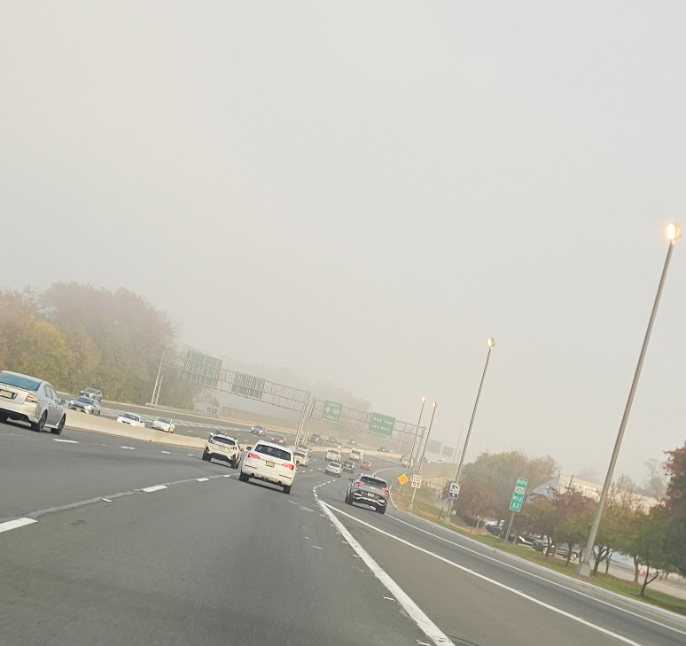
Sun disappeared. Also the fog on Rt.23 in Wayne this morning was something else.
-
What a run we're on.
-
I don't think that's an apples to apples comparison. I'm just saying when it's 35 for 2 hours on a late October morning with +8-9C 850s, that isn't cold like when you have a truly cold airmass overhead.
-
Looking at previous El Niño winters, South Bend tends to cash in, in the Spring (yuck). South Bend snow in March and April: 2015-16: 11" 2009-10: 0" 1997-98: 21" 1991-92: 18" 1986-87: 4" 1982-83: 13" 1972-73: 6" 1965-66: 17" 1957-58: 5"
-

2026-2027 Record-breaking El Nino
GaWx replied to Stormchaserchuck1's topic in Weather Forecasting and Discussion
This is just like the strongly E based 1997 was in the first half of Nov, but is unlike the 9 other strong+ Ninos since 1959, which had either neutral or -PNA then. -
It's hard to go for much cold with a strong Nino. Even if the SSW were to create strong HLB the strong Nino enhanced Jet may keep the what would be downstream Eastern Trough shunted NE. For the sake of winter weather lover's, let's hope that's not the Case and we get at least a period of wintry wx in what normally would be Nino's warmest Time (late Nov/December). Depending on how fast the Nino fades, we may get lucky late Winter.
-
Just did a readthrough of the old Snowtober threads. Lot of fun! We better get something to track soon(ish), but while this weather is boring, it's also totally fantastic
-
Nothing is fake…but I think we all get the point. Whatever it’s doing in your area/backyard at any given moment isn’t fake.
-
Sorry to hear that Jeff still far out so things could change but fun cold rain on election day yippie (sarcasm) .
-

2026-2027 Record-breaking El Nino
BlizzardWx replied to Stormchaserchuck1's topic in Weather Forecasting and Discussion
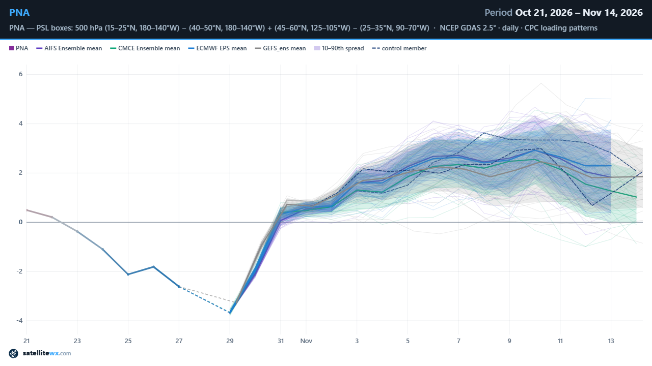
Good agreement on that positive PNA to start out November among all modeling systems. (Yeah I know I need to clean this graphic up a bit but I guess it'll get the job done for today)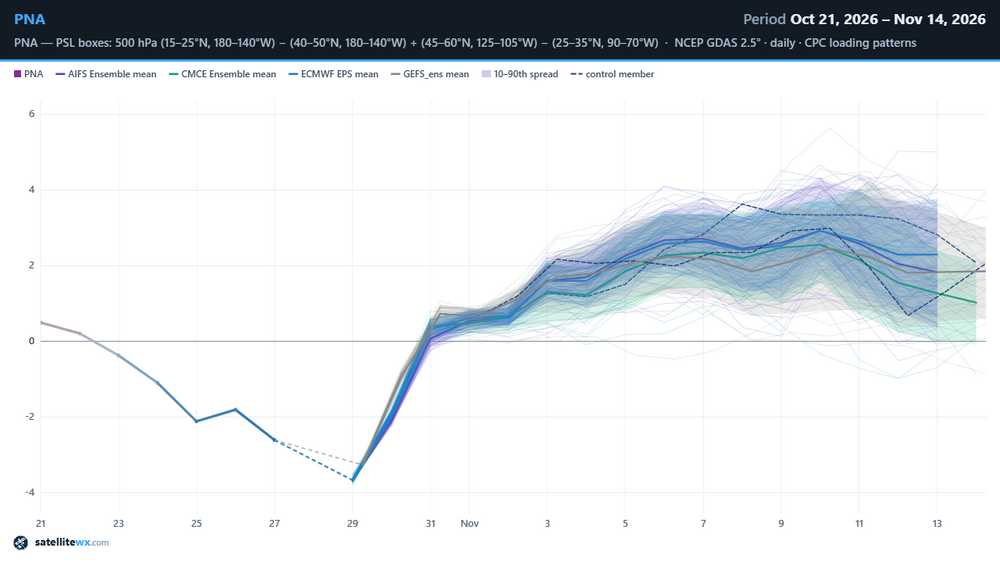
-
Yeah what once looked somewhat promising now looks like trash for thunderstorm fans like me. Probably just cold rain on Election Day. Lovely.
-

E PA/NJ/DE Autumn 2026 Obs/Discussion
The Iceman replied to PhiEaglesfan712's topic in Philadelphia Region
@PhiEaglesfan712you brought up 94-95 in another thread and I spent my lunch break looking into that winter, that is a very good sneaky analog. Not as strong of an el nino but the solar and PDO are pretty good fits. Outside of this storm, it was a pretty bleak winter. Kind of like 2015-2016 though -

2026-2027 Record-breaking El Nino
40/70 Benchmark replied to Stormchaserchuck1's topic in Weather Forecasting and Discussion
Of course it's going to be masked by the strongest El Nino in history in the seasonal mean, the question is whether it portends a favorable stretch of two during the winter, which often makes the difference between a bottom-dwelling winter in terms of snowfall and a middling season. -
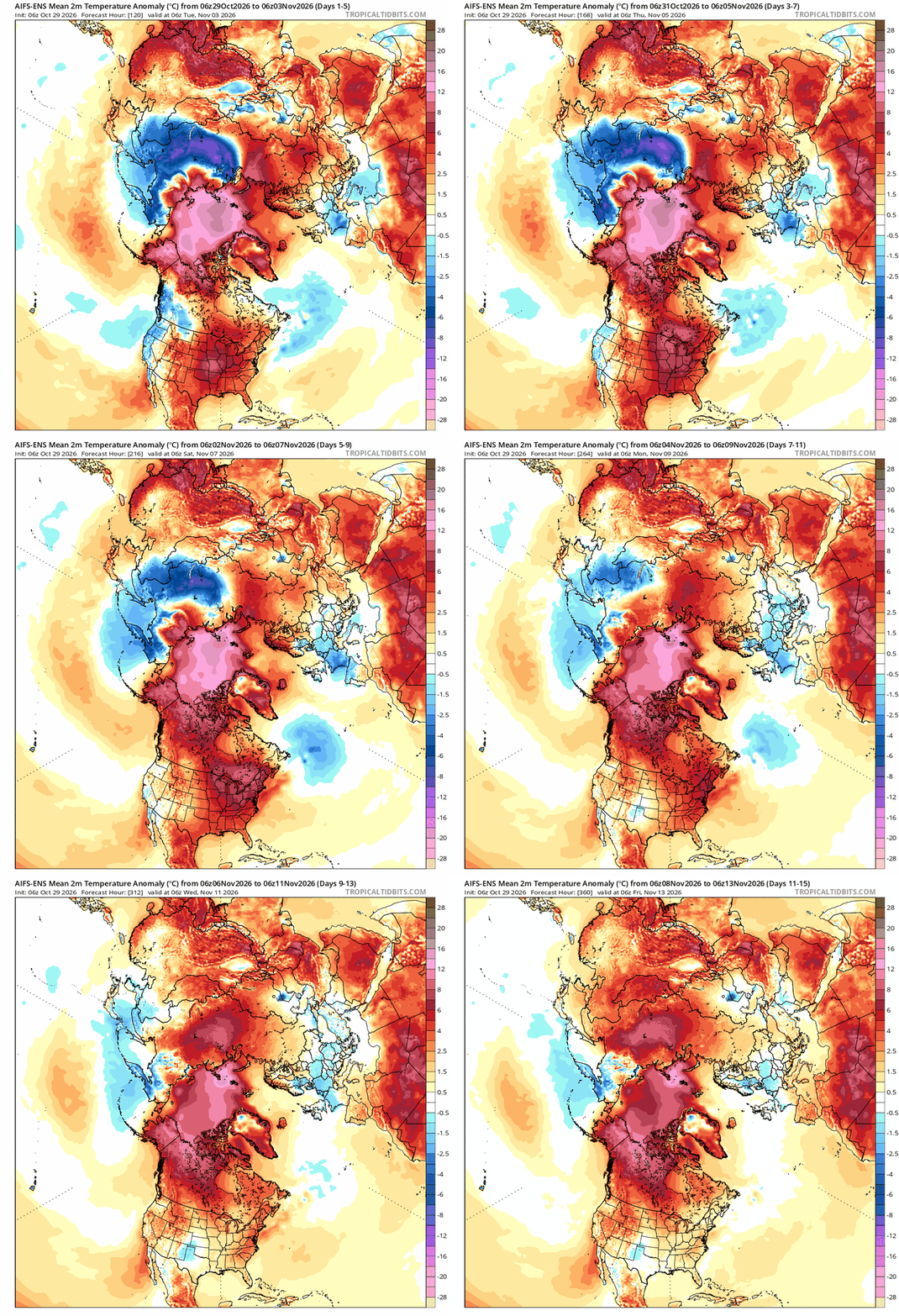
good luck building snowpack with this. ouch
-
Snow above 2kft is fake. @powderfreakwould even agree.
-
I remain bearish despite SSW talk. First, the signal is better for Europe than it is for NA. Next, we've seen Novembers with such warmings go cold in Europe and keep Eastern US ridge. Couple good X accounts that post more Southeast AmWx had sources (on X). Anyway, I like the warm forecast, so I just liked and scrolled on. Some chatter about Arctic blocking and snow cover came up. Wrong pressure signal though. Eastern Siberia is low press. China is normal. For cold we want China low press and Siberia surface high. That's the cold building. Currently eastern Siberia snow build is not blocking, but storminess. Continue robust Pacific jet. Continue mild Southeast US. Bonus: Scandinavia block could get more bullish for Europe. I hope not for their sake, and because one country keeps bombing civilian heating of another country that way.