All Activity
- Past hour
-
Time is freaking FLYING.
- 282 replies
-
- 1
-

-
- severe
- thunderstorms
- (and 7 more)
-
Surprised that its been 15 years since the April 27 2011 event... popped up on my FB memories
-
Trains magazine is indeed still around.
-

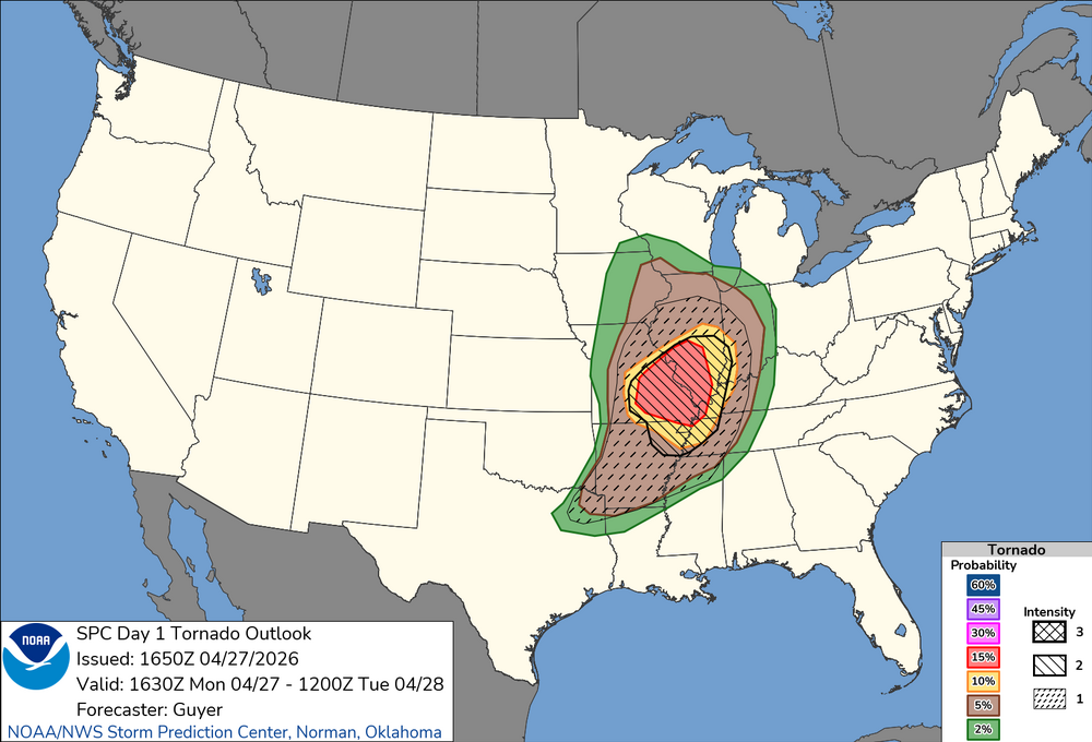
Potential Sever Weather Outbreak 4/27/2026
DaveNay replied to pen_artist's topic in Lakes/Ohio Valley
I can rebuild Sent from my SM-G991U using Tapatalk -
Sliced and diced from your post. (And I appreciate the info on climate and forecasting.) A friend was a train fan - I think there's a mag by that name - and he had multiple albums filled with various engines doing various things. Once he was a bit to close after a big snowfall and got slouced as the plow-fronted engine roared by. When I was 5, I was headed toward train-fandom. I knew more about trains back then than now, 75 years later. Temp over 70 after a low of 30; another '40' diurnal. Cut/split some firewood and worked up a good sweat.
-

Potential Sever Weather Outbreak 4/27/2026
Lurkess replied to pen_artist's topic in Lakes/Ohio Valley
Tornado watch 160 just issued for my area. I'm not real excited about this. I'm homebound now, with no real Tornado shelter. I can't believe I'm saying this because I love to watch nature do her thing, from afar of course. Cleaned up after 2005 outbreak, so heartbreaking. It truly sucks getting old. Cancer part 2.0 did this to me. Here's to hoping that being surrounded by oil fields will spare us. It has in the past. -
70.5F
-
Potential Sever Weather Outbreak 4/27/2026
DaveNay replied to pen_artist's topic in Lakes/Ohio Valley
Hello 60mph straight line winds! Sent from my SM-G991U using Tapatalk -
"Show me the pretty colors 48 hours out" Cmon, dont let me down now.
- Today
-
We May '05:
-
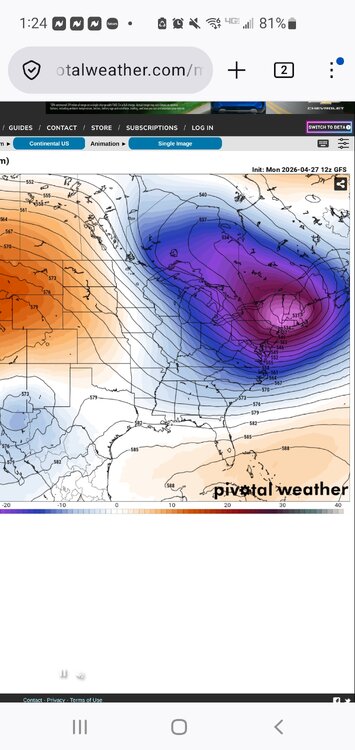
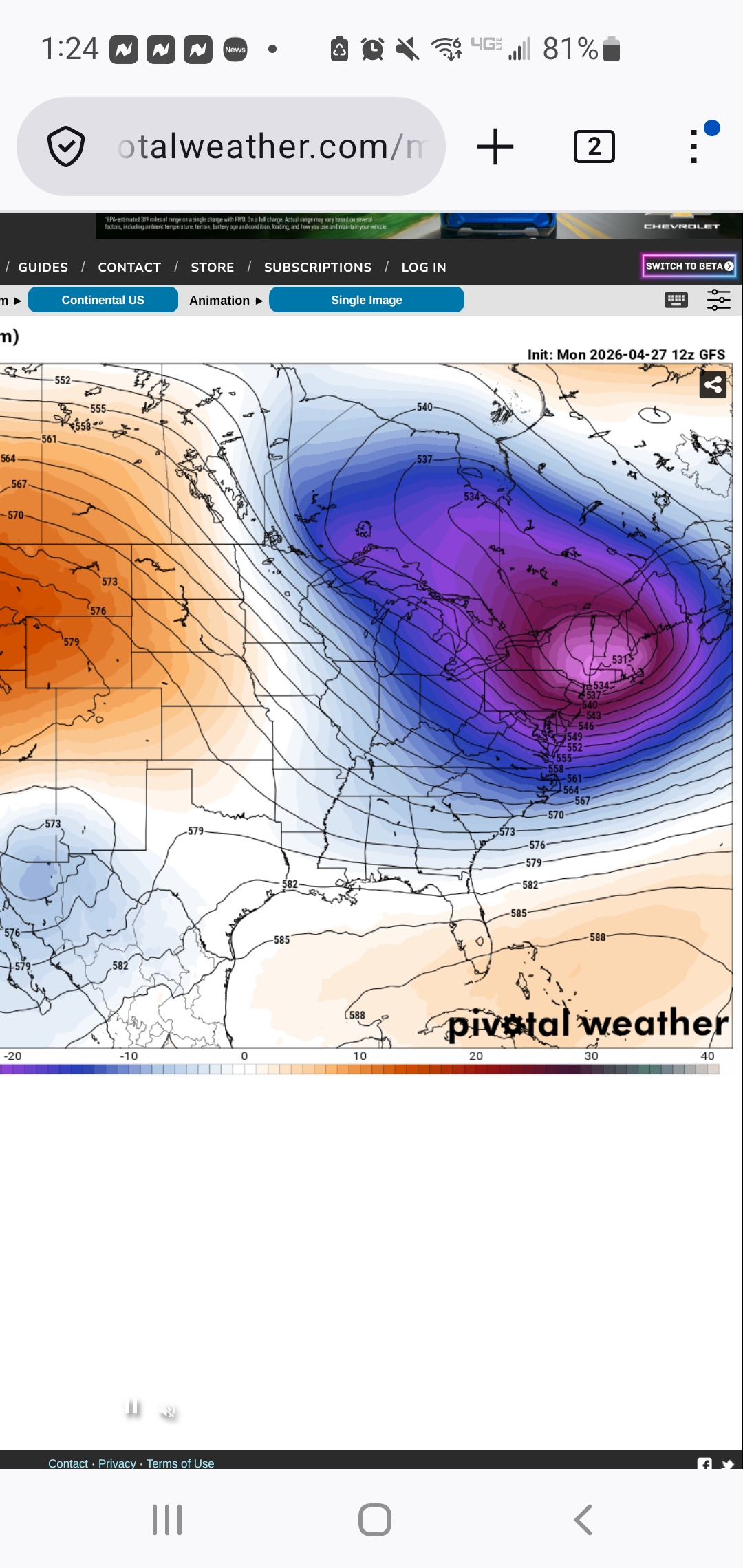
Monday 16:30 Day 1 update looks similar to 13Z. Moderate looks good. Our Mid-South will has almost as great a risk with prefrontal convergence and outflow left from this morning. The latter is a little diffuse but as of Noon Central Time had lifted just north of Dyersburg. Everything from the Missouri synoptic boundary to the convergence zones in Arkansas should light up this afternoon. Initial afternoon tornado threat West Tennessee and West Kentucky should evolve into straight winds this evening. This is the western third of our forum - not much east but thunderstorms tonight. Tuesday looks volatile enough to justify Enhanced in Arkansas with the update here in a few minutes. CAMs are nearly unanimous with outflow from today lifting north out of the Deep South into the Mid-South. Models have a clear boundary from the wind shift to the temps and dews. Synoptic boundary may be up on the Ohio River. Boundary I'm eyeing may be as far south as Memphis into Arkansas; otherwise, north of I-40 by Tue afternoon. Wind shear all levels will be robust that far south. In this case, on Tuesday, I'm much more interested in the cooking outflow boundary than the cooler synoptic one.
-
Your morning soaker is about my monthly total locally. Still under an inch
-
New outlook nudged things a bit south
-
Mid-day update from SPC edges slight risk a bit more south into NE TX/NW LA. HRRR very consistent with storms from Dallas eastward.
-
Nice morning soaking with 0.73". Brings April up to 7.46". Maybe some bonus showers later but main show likely over.
-
Still mostly cloudy here and 59. Crazy how long the fog can last here
-
Looked on point except for two days. Good forecast .
-

2026 Mid-Atlantic Severe Storm General Discussion
SnowenOutThere replied to Kmlwx's topic in Mid Atlantic
SPC has us in a day three marginal risk which prompted me to take a look NAM has a line of broken storms enter the region after a bit of clearing with 1000 CAPE values running right along I-64. We have 40-50kt of bulk shear and a good bit of lower level turning. Reminds me a bit of March 15th but less extreme and maybe a bit more heating. Wonder what yall think about it- 282 replies
-
- 1
-
-
- severe
- thunderstorms
- (and 7 more)
-
The rain gives it a certain vibe. I don't mind it when I'm walking around UVA.
-
Early to Mayorch 10 or so is normal here for Oaks . They leafed out early last week
-
I picked up 0.48" from the solid rain shield this morning. My April total is 7.19".
-

Potential Sever Weather Outbreak 4/27/2026
SchaumburgStormer replied to pen_artist's topic in Lakes/Ohio Valley
Game over for 72 north, but digging the rain -
remember these?
.thumb.png.122b0a0ff0d363266ed531b083d0ff20.png.43f05d63be8df057a4b26e7c0af599b4.png)
-
Lolz. A day or two maybe. https://www.usanpn.org/data/maps/spring
-
Pushing 70 now…absolutely prefect out there.


.thumb.gif.f92b16c631a1d15d405ed77b33f0710d.gif)


