All Activity
- Past hour
-
tough^
-

Pittsburgh/Western PA WINTER ‘25/‘26
Gordo74 replied to Burghblizz's topic in Upstate New York/Pennsylvania
Don’t like that warm tongue, but NWS seems to be discounting it given the surface temp for the hours leading up to it and throughout the event. -

“Cory’s in LA! Let’s MECS!” Jan. 24-26 Disco
weatherwiz replied to TheSnowman's topic in New England
Yup...great point. I'll say too...looking around at various locations, I would like to start seeing some stronger omega values popping up on some of these soundings. It's easy to get carried away with ratios given everything but we aren't going to automatically snag very high ratios because the DGZ is deep and its cold. There are really a ton of details to go over and analyze on this -

“Cory’s in LA! Let’s MECS!” Jan. 24-26 Disco
mahk_webstah replied to TheSnowman's topic in New England
A bit low -
This is exactly what we want to look for now. Absolute firehose from 6-18z. As for ratios, I think the dream of lots of high ratio snow is mostly gone with the way this storm has evolved. I think the really early stuff (6-10z or so?) could be higher ratio when the column is coldest. But snow will also be lighter then. But maybe we can do a 12-15:1 on average during that? But after 10z-ish, I think we fall back into normal range. If you’re in a subsidence band at some point, ratios will suck. If you get deathbanded, they’ll go back up for a time. But probably averaging a normal 9-11:1.
-
-19 here at the house. Just might be hitting the bottom now. Since this is an advection cold the normal low spots on my drive in didn’t bottom out in the -20s
-

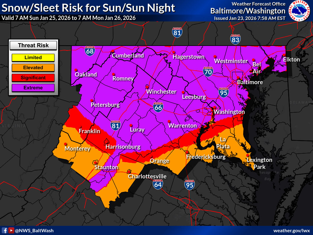
Possible Record Breaking Cold + Snow Sunday 1/25 - Tuesday 1/27
jdj5211 replied to TriPol's topic in New York City Metro
I’m right off 287 in Morris County. Seems like it might be right near the sleet/snow battleground. Curious to see where I end up. Preparing for 8 or 20 at this point . -

January 24-26: Miracle or Mirage JV/Banter Thread!
yoda replied to SnowenOutThere's topic in Mid Atlantic
-

Possible Record Breaking Cold + Snow Sunday 1/25 - Tuesday 1/27
MJO812 replied to TriPol's topic in New York City Metro
Who knows if the models are wrong with the warming. Lets just see how the storm progresses and take it from there. Saying no one will see double digits at this time is irresponsible. -

January 25/26 Jimbo Back Surgery Storm
Tyler Penland replied to Jimbo!'s topic in Southeastern States
The Accuweather one still had me getting 8-12" of snow yesterday evening- that hasn't been on the table for days. -
 I believe the NAM has mixing up to Poughkeepsie. I will let you know since I am North of 84.
 -

January 24-26: Miracle or Mirage JV/Banter Thread!
H2O replied to SnowenOutThere's topic in Mid Atlantic
I think 6-7 is good for my hood. See what i did there kids? -

January 25/26 Jimbo Back Surgery Storm
NorthHillsWx replied to Jimbo!'s topic in Southeastern States
RAH mentions decreased QPF on overnight modeling for the NC piedmont in their recent AFD. Still going with 0.5-0.75” ZR -
Because it’s only an app. It can’t hold all the information. It changes several times a day. It’s great for watching radar, but never ever use an app to make your plans regarding the weather.
-

1/24-1/25 Major Winter Storm - S. IL, IN, MI and OH
michsnowfreak replied to A-L-E-K's topic in Lakes/Ohio Valley
I guess I cant even fathom a comparison, because I know that under no circumstances would I EVER live in TX...but what a slap in the face how prone to ice they are in deep winter cold shots. Its like, you finally get DEEP winter cold with surface temps that scream powder but you get stuck with freezing rain and sleet. -

Central PA Winter 25/26 Discussion and Obs
pasnownut replied to MAG5035's topic in Upstate New York/Pennsylvania
it really does have that feel. -

January 24-26: Miracle or Mirage Thread 2
PrinceFrederickWx replied to mappy's topic in Mid Atlantic
This seems a little bullish for southern MD, unless it's also including sleet. I hope they're right anyway. -
Thankfully they have a long time to catch up. I think some of Denver's biggest storms have been in April.
-
Because weather apps are based on nothing we in this group value: precedence, analogs, multiple data points and human input. It’s why I hate that any of these apps bother. All it does is mislead the public.
-
Not sure how much it matters or if it’ll even translate to the other 12z runs, but there is a major change at H5 by hour 30. The northern stream is not digging anywhere near as much as it was at 6z. There’s also a better press of mid level cold air.
-

Central PA Winter 25/26 Discussion and Obs
anotherman replied to MAG5035's topic in Upstate New York/Pennsylvania
Good lord. It will change a million times but it's giving me 2010 vibes. -
I was just looking at it roll in as well and was thinking it looked a bit more south.
-

-

1/24-1/25 Major Winter Storm - S. IL, IN, MI and OH
Radtechwxman replied to A-L-E-K's topic in Lakes/Ohio Valley
At this point I may get nothing out of this. Precip shield and totals keep shrinking more and more on nw side. Euro caved to gfs. Guess it was nice while it lasted. Will be shocked if I get 1-2in. -
1/23/26-1/25/26 Winter Storm Thread
Save the itchy algae! replied to AMZ8990's topic in Tennessee Valley
The ideal environment for freezing rain accretion is just below freezing temperatures at the surface and a mist or very light rain falling into a gentle steady breeze to aid droplet particulation. I’m not sure if that’s an actual word the point being the bigger the droplet the less likely it will stick. Too much breeze and the water wont stick and has drying function, as does too low of a temperature to the moisture content. The fly in the ointment is already fallen sleet/snow at lower temperatures as it can supercool rain falling in lower temps and immediately form concrete. But heavier rain can and will overcome that, especially over a long duration.