All Activity
- Past hour
-

Chester County PA - Analytical Battle of Actual vs. Altered Climate Data
chubbs replied to ChescoWx's topic in Climate Change
Lets see what the raw data says. After all bias adjustments are based solely on raw data. If the the steel mill impacted the Coatesville station it would be reflected in the raw data and in the NCEI bias adjustment. However raw data from Coatesville and West Chester clearly clearly shows that station changes drive the Coatesville bias adjustments not the steel mill. Below is a plot of Coatesville 1SW minus West Chester and the Coatesville bias adjustment (right axis). A station change at either Coatesville or West Chester causes a sudden change in relative temperature of Coatesville and West Chester. While a growing steel mill or an urban heat island in one of the towns would cause a gradual change in the difference between the two stations. There are many sharp changes in Coatesville's temperature relative to West Chester. These are all station changes. There is no indication of a gradual long-term trend so a large change in the steel mill impact can be ruled out. Station changes are the primary cause of Coatesville's (and West Chester's) cooling. The Coatesville bias adjustment (right axis) tracks the raw temperature data at Coatesville and West Chester closely, except when West Chester had station changes: 1915, the 1920s, the 1960s and with the West Chester move in 1970. Both stations start out at about the same temperature in the 1890s. After 1920 Coatesville cools relative to West Chester and is about 2F cooler than West Chester from the late 1940s to the early 1960s. Doe Run Road is the coolest Coatesville station location. West Chester cool briefly in the mid-1960s and then cools by roughly 2F with its 1970 move. In the early 1970s, Coatesville 1SW and West Chester have similar temperatures again. Most of the chart movement is due to Coatesville station changes until the 1960s when West Chester started to cool. Both stations cooled by roughly 2F since the 1890s due to station changes. This exercise is another feather in NCEI's cap. Bias adjustments are needed in Chester County and the NCEI method matches the raw data as it should. .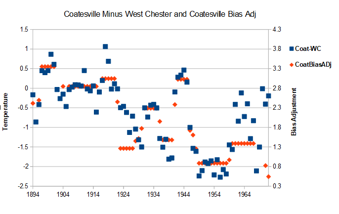
-

Central PA Summer 2026 Discussion/Obs Thread
pawatch replied to Voyager's topic in Upstate New York/Pennsylvania
54 degrees this morning. Enjoy the weekend! -
 Users can conveniently locate the right products by clicking on https://mexicanrxrateing.club/#.
 - Today
-
The only thing I disagreed with was taking Rogers out at 88 pitches. But to be fair...Garcia didn't make a bad pitch; it landed way below the zone and the dude somehow golfed it. But that only tied the game; the blown opportunity in the 9th, stupid error in the 10th. Core issues once again that have been going on before this year, smh
-
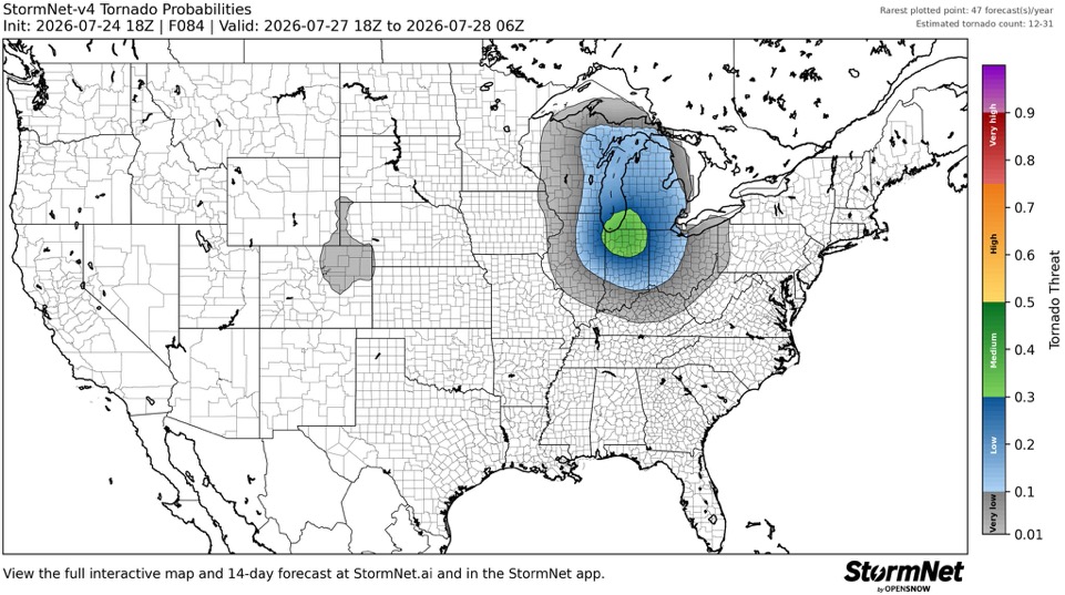
Getting intrigued for Monday.
-

2026-2027 Super El Nino
TriPol replied to Stormchaserchuck1's topic in Weather Forecasting and Discussion
Warm how? Am I going to need an air conditioner? -
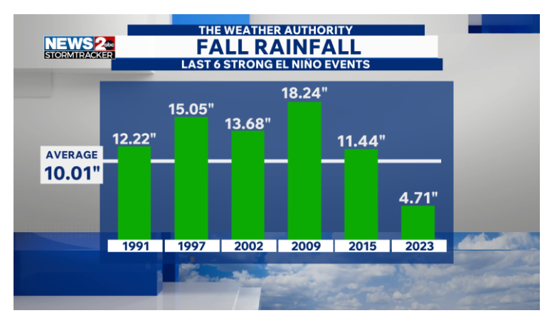
Most strong Ninos produce moisture,as to what happens this winter is surely uncertain,i still think NOV could dry out,severe Dec cold Jan and Feb,March are crap shots,but probably AN,thats just my opinion and surely might not be right
.png.253e59b0d58241a9e42fcf77569827df.png)
-

E PA/NJ/DE Summer 2026 Obs/Discussion
JTA66 replied to PhiEaglesfan712's topic in Philadelphia Region
Hearing the first katydids of the summer. -

Pittsburgh PA Summer 2026 Thread
TimB replied to TheClimateChanger's topic in Upstate New York/Pennsylvania
The low of 51 yesterday was the first time PIT has been below 54 in July since 2014. It got below 54 at least once every single July from 1976-2003. -

2026-2027 Super El Nino
40/70 Benchmark replied to Stormchaserchuck1's topic in Weather Forecasting and Discussion
That Andrej Flis guy from severe weenie EU is full of shit again....only valid piece of analysis on that post is the El Niño favoring SSW over La Niña and the EURO blocking signal. I go in depth on his selective pruning of information at the end of my blog...should post tomorrow night. -
Yet another solid 500 trough for July, This time actuality cuts-off and is slow to move out, so looks like Mon-Wed tstms each day in some form, and maybe Thu if the ECMWF is right. Tue appears the best for svr wx currently. GFS and ECMWF don't hesitate to replace this 500 low w/ another one just beyond week, so active times ahead it seems.
- 1,468 replies
-
- 1
-

-
- severe
- thunderstorms
- (and 7 more)
-
Yes, I thought of the terms used for CAPE here, but that's what is in literature. Maybe "wide" and "narrow" CAPE is better!
-

Spring/Summer 2026 Pattern Discussion Thread
jaxjagman replied to Carvers Gap's topic in Tennessee Valley
Maybe we will get a break with clouds upcoming,be cool to watch https://www.amsmeteors.org/meteor-showers/meteor-shower-calendar/#Perseids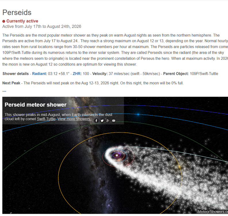
-

2026-2027 Super El Nino
Jebman replied to Stormchaserchuck1's topic in Weather Forecasting and Discussion
I love your thinking, snowman! I want tons of rain! I want transport of moisture from the deep tropics, too! This is a monster Nino! I want monster rains this autumn and winter and in Spring 2027! -
Riding any models with the wild SSW storm motions
-

2026 Mid-Atlantic Severe Storm General Discussion
Eskimo Joe replied to Kmlwx's topic in Mid Atlantic
"Sub 990 lows don't go quietly into the night." @Rainshadow -
Oh I bet definitely a perfect view .
-

2026-2027 Super El Nino
snowman19 replied to Stormchaserchuck1's topic in Weather Forecasting and Discussion
Very strong signal for a warm east this December….El Niño/+QBO has been a slam dunk for that since 1979. And I would be shocked if the southwest isn’t wet this winter given the super Nino/++PMM combo that really juices the STJ -
Tonight's game is on Albernaz. Not ready for prime time
-
Looking forward to seeing a frontlit anvil on eastern horizon at sunset.
-

Mountain West Discussion
mayjawintastawm replied to mayjawintastawm's topic in Central/Western States
Glorious here, 0.45" from an outflow-generated storm. Finally. Most in 6 weeks or more. Temp went from 96 to 66 in a couple of hours. You'll get it, eventually! -
A huge plume of rain literally 2-3 miles to my west for the last hour, yet it refuses to come east.
-
-
 Lol…C MN…puff puff pass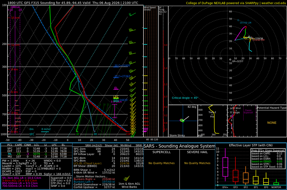
-
A little overmixed in fantasy land