All Activity
- Past hour
-
Re Sunday severe threat from SPC -- 30 wind was backed westward to i81 corridor... 2% tor also moved slightly NWward compared to the morning Day 2 OTLK Day 2 Convective Outlook NWS Storm Prediction Center Norman OK 1237 PM CDT Sat Jun 13 2026 Valid 141200Z - 151200Z ...THERE IS A SLIGHT RISK OF SEVERE THUNDERSTORMS FROM NORTHERN GEORGIA NORTHWARD INTO PORTIONS OF SOUTHERN NEW ENGLAND... ...SUMMARY... Scattered severe thunderstorms capable of damaging wind gusts are expected across the Mid-Atlantic vicinity Sunday afternoon and evening. Additional strong to severe storms are expected across the Upper Ohio Valley and Lower Great Lakes area. ... Synopsis ... Broad troughing will exist across the eastern US on Sunday with several smaller-scale troughs moving through a longer-wave trough. At the start of the forecast period, one shortwave trough will be moving across the Northeast and a secondary low-amplitude trough will approach the eastern US later in the day. As this happens, low-mid-level southwesterly flow will increase to around 40 knots, providing effective-layer shear sufficient for thunderstorm organization. Surface dewpoints will increase into the low 60Fs perhaps as far north as central/southern New York ahead of an eastward advancing cold front. Diurnal heating of this moist airmass should result in MLCAPE perhaps as high as 1500-2500 J/kg across the southern Mid-Atlantic, to perhaps 1000 J/kg across portions of New York. Multiple rounds of thunderstorms will be possible along and ahead of the surface front during the afternoon and evening. Damaging wind gusts will be the main concern with these storms, although an isolated tornado will also be possible. Strong consideration was given to increasing wind probabilities to 45% (Level 3/Enhanced) across the central/northern Mid-Atlantic region, but opted to defer any upgrade to later outlooks after collaboration with local offices. Additional bands/clusters of storms are likely to develop during the afternoon across portions of the Upper Ohio Valley into PA/NY. While instability will be lower across this area, deep-layer flow will be stronger. Linear bands and clusters will pose a risk for isolated severe/damaging wind gusts through the evening.
-
We had all the severe storms here in the west. I had some pea size hail with torrential rainfall yesterday.
-
100% GSD day. More of the same tomorrow.
-

E PA/NJ/DE Summer 2026 Obs/Discussion
PhiEaglesfan712 replied to PhiEaglesfan712's topic in Philadelphia Region
KOQN Airport's max and min needs to be fixed. 19 should be the max value, and 9 the min. -
Currently 94/82 for a feels like temp of 118. Feels absolutely miserable out there.
-

Central PA Summer 2026 Discussion/Obs Thread
Itstrainingtime replied to Voyager's topic in Upstate New York/Pennsylvania
From what I read on CTP's discussion this morning, an extremely rare day 6 outlook for central PA next Thursday. -
So much for rain chances through first half of next week
- Today
-

Central PA Summer 2026 Discussion/Obs Thread
Superstorm replied to Voyager's topic in Upstate New York/Pennsylvania
Yeah, could be wicked. . -

2026-2027 Super El Nino
roardog replied to Stormchaserchuck1's topic in Weather Forecasting and Discussion
Does it look like the extreme -SOI will continue? It'll be interesting to see how low the 30 day average will go? -
10/10 day
-
(002).thumb.png.6e3d9d46bca5fe41aab7a74871dd8af8.png)
Central PA Summer 2026 Discussion/Obs Thread
ChescoWx replied to Voyager's topic in Upstate New York/Pennsylvania
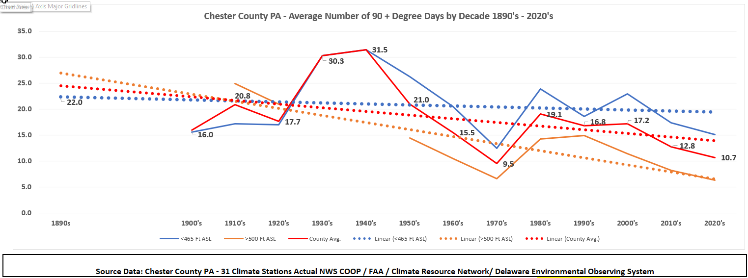
Here in Chester County PA most spots have seen an above normal amount of 90+ days so far this season. Below are the number so far this season by station along with the average per typical season along with the most and least by station. You can clearly see how relative elevation across our area impacts the number of such days. Also below you can see our average annual number of 90+ days is showing a clear reduction in number as we compare past decades to the 2020's.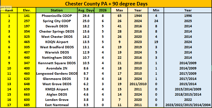

-
E PA/NJ/DE Summer 2026 Obs/Discussion
ChescoWx replied to PhiEaglesfan712's topic in Philadelphia Region
Here in Chester County PA most spots have seen an above normal amount of 90+ days so far this season. Below are the number so far this season by station along with the average per typical season along with the most and least by station. You can clearly see how relative elevation across our area impacts the number of such days. Also below you can see our average annual number of 90+ days is showing a clear reduction in number as we compare past decades to the 2020's.
-

2026-2027 Super El Nino
GaWx replied to Stormchaserchuck1's topic in Weather Forecasting and Discussion
Despite being steady last 7 days, I predict that 3.4 will warm by 0.3 in Mon’s update because of how the weeks compare. -
Three more months please.
-
Wednesday (Thursday to a lesser extent) looks thread-worthy, might get one going in a bit unless anyone else wants to jump on it
-
Good news vs yesterday though: RDU 6 cooler and N vs W winds vs 24 hrs ago. For first time in days, RDU not hottest in SE. Ft Bragg is 4 hotter than RDU, for example.
-
Total for the 2 days was .03. Desertification has begun
-

2026 Mid-Atlantic Severe Storm General Discussion
Eskimo Joe replied to Kmlwx's topic in Mid Atlantic
You mean June 1, 2012? The moderate risk day that almost went full gang busters? -
With so many of the 12z western ROABs missing, I wonder if it's going to be a summer of short term model guidance beating mid range?
-
No doubt. I was a little hopeful, but am slowly learning to basically ignore any rain threats coming from the NW. They simply don't make it past the Yadkin river.
-
Had another half inch of rain fall too. Grass and flowers are looking better.
-
Didn't even know it rained up at home while at work or at work. Building is so quiet. Did watch storms blow up over point pleasant on our bridge cams. North bergen got flooded. Never seen it on this side of north bergen along Hudson. https://www.threads.com/@amprincipe/post/DZgsviGEWZ5?xmt=AQG0Yuy2QCZhP2PHwK3F_-vf2Hh6JEmkiXjZgD4kSB6pCIdjNk-wOsPK-n0PC4zJj8fnsm2N&slof=1
-

2026 Mid-Atlantic Severe Storm General Discussion
high risk replied to Kmlwx's topic in Mid Atlantic
June 1, 2011 also comes to mind when looking at this setup. You're absolutely correct that a Day 6 outlook for this part of the country is a rare thing, and there certainly is high end potential. Verbatim, I think that the overnight solutions would really favor New England for the greatest potential, but we'll see how the synoptic evolve over the next few days. -

E PA/NJ/DE Summer 2026 Obs/Discussion
LVblizzard replied to PhiEaglesfan712's topic in Philadelphia Region
SPC put out a somewhat rare day 6 15% area for PA/NJ. Would be really nice to get a severe day sandwiched in between all these cool, low humidity days.


.thumb.jpg.ad3a2e31d30aff035044689b311a0540.jpg)


