All Activity
- Past hour
-
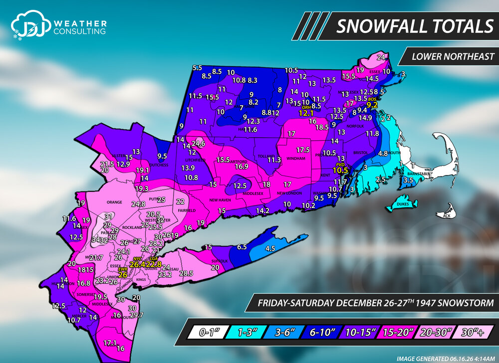
I recently did maps and updated the site for all these storms. March 1960, two Feb 1969 storms, Dec 1992, Apr 1983 and others. Just finished Boxing Day Dec 1947 snowstorm last night. https://www.jdjweatherconsulting.com/historic-storms
-
That data set seems to have a great deal of -PDO warm ENSO events, which may explain the curious QPF deficit. Super events were very dry over the interior, implying a coastal storm track...small sample size, I know.
-
Lawn should be a goner by the weekend. not expecting much Thursday
-
I wouldn't completely dismiss this rather uncanny resemblance to last season, despite ENSO...one hallmark of CC that I have noticed is that these patterns tend to stagnate and become a theme over several seasons.....previously, we had the never-ending cold west/warm east +WPO look, but the north Pacific seems to have flipped starting with the the 2024-2025 season. It has remained rather dry, albeit colder, but ENSO is likely going to be the vehicle for change with respect to having precipitation pick up.
-
CSU MLP is pretty garden variety (15% in a big, broad area). CIPS is pretty unenthused. NCAR is still heavily bullish. I think most of us know this at this point is not going to be an outbreak in our region. But let's see how things evolve with Wednesday convection and timing and such.
-

2026 Mid-Atlantic Severe Storm General Discussion
high risk replied to Kmlwx's topic in Mid Atlantic
Deep westerly flow here is never a good environment for widespread convection. That said, the dew points aren’t progged to lower Thursday afternoon as much as I would have expected, and the RRFS is able to generate a few scattered storms. And any storm in this kinematic environment would be interesting. Still, the best chance of some rainfall might be early Friday as a weak wave moves along the front.- 756 replies
-
- 1
-

-
- severe
- thunderstorms
- (and 7 more)
-

2026-2027 Super El Nino
snowman19 replied to Stormchaserchuck1's topic in Weather Forecasting and Discussion
And the new WWB generated DWKW has begun to make its trek eastward with more warming to follow…. -
Just seems like its been several Junes where we had a 7-10 day stretch of 70’s with periods of rain. Feels like most recent June’s brought on summer heat full bore.
-
Mon-Tue looking like a shades closer
-
Min 51.8° Nice morning. On our way to u70s.
-
58/49… wonderful morning.
-

Central PA Summer 2026 Discussion/Obs Thread
Mount Joy Snowman replied to Voyager's topic in Upstate New York/Pennsylvania
Tried to get an early morning photo of MDT for you guys, through the dirty Amtrak window and all. Anyway, can confirm no jets affecting the weather station ha.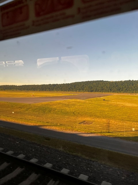
-
He’s got Thursday on lock.
-

2026 Mid-Atlantic Severe Storm General Discussion
dailylurker replied to Kmlwx's topic in Mid Atlantic
So just boring ass drought? Looks like it all misses to the north where they have a rain surplus lol The 10 day gfs precip map really tells the story. Just incredibly boring. - Today
-
Guidance is hot dry garbage
-
Chilly start. 52° at Worcester and lots of 40s out hippie way.
-
WF staying south of the lake always a good bet
-
56 imby. 32 at canaan nwr.
-
Electric in my backyard last night, doing the shimmering/flickering deal. Everyone should leave some high grass and leaf piles in a few patches to give them a fighting chance. I'm just a few blocks from the asphalt and concrete canyons of downtown silver spring... But I have many lightning bugs
-
2026 Mid-Atlantic Severe Storm General Discussion
dailylurker replied to Kmlwx's topic in Mid Atlantic
Just got done reading all the hype on Facebook lol. I just want rain. I don't care about severe. Hopefully that happens. -
2026-2027 Super El Nino
snowman19 replied to Stormchaserchuck1's topic in Weather Forecasting and Discussion
“Potentially Historic #ElNino in Making[emoji409][emoji91] Just Days After the American Weather Agency NOAA Declared the Arrival of El Nino, Today the Australian Weather Agency BOM has Declared the Event. According to BOM, Almost Half of the Models now indicate that this Event would be among the Strongest Ever in the Recorded History[emoji91] Some Notable Record Already Smashed by the Present Evolving El Nino are mentioned below- 1) The Traditional Nino 3.4 Index (Primary El Nino Monitoring Region) is now at +1.45c. This is the Highest Ever Temperature Achieved at this Stage of an Evolving El Nino and Beats all Previous Super El Nino Events) 2) This is Fastest Ever Flip from a Mature La Nina State Early in the Year to Almost a High End Moderate El Nino within a Span of just 6 Months[emoji3062][emoji409]” -
Central PA Summer 2026 Discussion/Obs Thread
Mount Joy Snowman replied to Voyager's topic in Upstate New York/Pennsylvania
A crisp 51 when I left the house. A+ day on tap. Onward. -

Central PA Summer 2026 Discussion/Obs Thread
Superstorm replied to Voyager's topic in Upstate New York/Pennsylvania
51.6F this morning in Lanco. Very refreshing. . -
Guidance is hot garbage for Thursday.
- 756 replies
-
- 1
-

-
- severe
- thunderstorms
- (and 7 more)
-
I have shed the shorts and short sleeve for sweats and long sleeve flannel! What a beautiful early fall morning!! 44.7 at 6:10. Staunton record low for June 16 was 43 in 1961. Charlottesville from the same air mass 48 in 1961. D.C. record was 50 in 1917. Va. Tech Canaan report at 6:10 was 34.7.