All Activity
- Past hour
-
Possible just SW of NYC. Looks like a good south Jersey severe alley day. .
-
The HRRR which had looked impressive for tomorrow afternoon no longer does with the 12z run - unless you are south of DC.
-
Talk of sustained 90/75 this early on is setting yourself up for failure. I expect we all be cooking by late June
-

2026-2027 Super El Nino
A-L-E-K replied to Stormchaserchuck1's topic in Weather Forecasting and Discussion
time 2 torch -

2026 Mid-Atlantic Severe Storm General Discussion
Eskimo Joe replied to Kmlwx's topic in Mid Atlantic
Probably why the 30% wind was added. -

2026-2027 Super El Nino
GaWx replied to Stormchaserchuck1's topic in Weather Forecasting and Discussion
Big news in the ENSO measuring/ranking world: ECMWF yesterday finally followed NOAA’s lead and implemented its own version of a relative Nino 3.4 index! Although the general idea is the same, it is its own unique relative index and thus is calculated somewhat differently. Also, they use different databases to determine SSTs. Here’s a graph showing both the traditional and the new relative Nino 3.4 SST anomalies going back to 1982: Note the following based on this ECMWF table: -Most recently relative was ~0.5 cooler, similar to NOAA -It has 2023-4 ~same as NOAA with ~+1.5/2 (relative ~0.5 cooler) -Like for NOAA relative, relative has been cooler since ~2014. -Similar to NOAA, the relationship was much more variable prior to 2014 including: -only small differences between relative/non-relative for 1997-8 just like for NOAA -relative being a large ~0.6C warmer in 1991-2 just like NOAA -relative being ~0.35 warmer in 1982-3 similar to NOAA’s ~0.3 warmer and warmest on record like for NOAA -But, ECMWF has bigger variations/extremes than NOAA for both El Niño and La Niña: -The ECMWF’s strongest La Niña since 1982 is just as for NOAA 1988-9, but it’s way down at -2.5 (for both) vs only -1.9 for NOAA (for both) -The ECMWF’s strongest El Niño is 1982-3 for both measures and is significantly stronger than NOAA with +3.1 relative/+2.75 non-relative vs NOAA’s +2.5/+2.2. This probably should be kept in mind when looking at the Euro’s ENSO progs vs history —————— Measuring the strength of El Niño – introducing Relative Niño indices 10 June 2026 However, as the climate warms, interpreting these anomalies becomes more challenging. Rising background temperatures can make recent El Niño events appear stronger, and La Niña events weaker. To address this, with the support of the WMO, ECMWF is introducing an additional measure of El Niño strength, alongside the more traditional Niño 3.4 SST anomalies, in its seasonal forecast from 1 June 2026: the Relative Niño indices. These indices compare the Niño 3.4 region with the rest of the tropics at the same time, offering a perspective that is less sensitive to long-term warming. This will provide an additional tool for describing the likely strength of an upcoming El Niño event. Even with this adjustment, current forecasts suggest that El Niño may be unusually strong later in the year. https://www.ecmwf.int/en/about/media-centre/science-blog/2026/measuring-strength-el-nino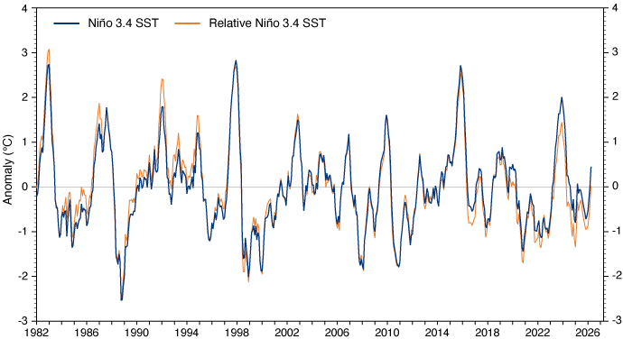
-
Months and months of torch talk from the usual suspects builds the zeitgeist of the board, so we are conditioned to have unrealistic expectations. throw in some Greta, and boom
-
Mesoscale Discussion 1086 NWS Storm Prediction Center Norman OK 0953 AM CDT Thu Jun 11 2026 Areas affected...eastern Iowa into northwest Illiniois and northeast Missouri Concerning...Tornado Watch 311... Valid 111453Z - 111630Z The severe weather threat for Tornado Watch 311 continues. SUMMARY...Severe wind gusts remain likely across eastern Iowa, northwest Illinois, and northeast Missouri. A tornado risk may develop from northeast Missouri into west-central Illinois. DISCUSSION...An MCS with a history of producing measured severe wind gusts continues to quickly move across eastern IA. Two main surges are evident within this north-south line, with the southeast IA portion currently stronger than the section moving into northeast IA. Meanwhile, a trailing portion of the MCS extends southwestward into northern MO, where backbuilding is occurring. It appears the environment farther east across IL and southern WI will need to undergo significant destabilization for this existing MCS to remain severe into the afternoon. 12Z soundings from DVN and ILX show a stabilized air mass from the overnight MCS, with GPS PWAT sensors indicating a deeper moisture gradient across central IL. However, visible satellite shows strong heating occurring ahead of the MCS, and modest southwest winds will allow for moisture to gradually return northward across IL and vicinity. Some tornado risk exists as well, especially along the southern/southeastern fringe of the MCS. Here, 0-1 km SRH will remain strongest, and the environment should become more favorable later in the day as the air mass become more volatile. ..Jewell/Gleason.. 06/11/2026 ...Please see www.spc.noaa.gov for graphic product... ATTN...WFO...LOT...ILX...LSX...DVN...DMX...EAX...
-
LWX did mention this too in their AFD On the mesoscale, will have to monitor the evolution of an MCV associated with severe early morning storms over IL/IN as it moves east toward the region late this afternoon, and how that interacts with the above mentioned lifting mechanisms (not to mention any residual outflow from the early morning PA MCS). It is plausible that these features enhance convective development by resulting in slightly higher forcing and perhaps some subtly enhanced mid-level flow. This would result in more widespread storms and an uptick in damaging wind potential locally.
-
That's funny you wrote this... I was wondering how being +2 to +5 for 10 days isn't sustaining? I guess the subjective side of that needs to be brown out 100s for 10 straight days and with Locus swarms, brimstone and and booming voice from the heavens that says, "I don't like you!" lol
-
If anyone is forecasting based upon climate ( and I'm not saying that's what anyone or source actually did - ) they take risks to put it nicely. More of a philosophy of approach op ed: Climate shouldn't be used as much of any correction for any scenario. We look over all these modeling depictions and/or cinemas going out way in time.. comparing those to trends ( which trend is a lost/deeper art than most are aware frankly but that's another discussion - ), we get an idea of/what the biases may end up like. That's our prototype/beta forecast. Once we have that, we can/may/maybe should, reflect on whether or not climate should factor? Frankly, it won't factor very much. Why? because climate is a mean of everything that happens. It says nothing about the SDs that took place along the way - in fact... it hides them! Climate invocation should be limited to the obvious: it's probably won't snow in June; it probably won't be 90 in January - though revisit that in 30 years lol The fact that Climate Change is hugely coherent and objectively real, and cannot be denied by anyone that is not diluted ...eh hm, means that all the above is especially made more true. Because climate inference, itself, is problematic when the proverbial goal posts are moving - not just moving, but accelerating, too.
-
Cue @CoastalWxto say that is the only acceptable weather in summer.
-
Comma head of the complex seems to be moving a bit more NE now. We’ll see, but this is gonna be an interesting day for sure.
-
Yeah, dews are 70F right now up here. It’s warm and humid. It’s barely mid-June. Do we need 95F over 75F now until September?
-
IKK is the spot
-
It’s 6/11. BOS normal is 75/58 today. It’s going to be 2 weeks of WAN by Sunday. We already have powderfreak running his AC at night. I’m not sure what people want or expect?
-
Enhanced and moderate risk in the Midwest so I think it's possible
-
2026 Mid-Atlantic Severe Storm General Discussion
Eskimo Joe replied to Kmlwx's topic in Mid Atlantic
SPC mesonalayis is pretty loaded at 10:30 am for us. Incredible surface CAPE, stouts LI's, and decent low level lapse rates. Only thing lacking is shear. If something fires up today it'll have a solid airmass to work with. Hmm...even some decent mid level lapse rates west of I-81. I wonder if we have a bit a remnant EML trying to crest the mountains?- 485 replies
-
- 2
-

-
- severe
- thunderstorms
- (and 7 more)
-
Quite possibly. The latest HRRR already has a better handle, and never gets the WF back to even I-80.
-
Yeah we get it, Central Park runs cool in the summer. It has for many years. No one seems to care to fix it any time soon, so we don't really care about that 1 site either. The island was pretty much all trees before humans cut them down, so maybe that site is actually the most accurate for what conditions should be before humans stripped all the land.
-
89.0, HI approaching 100
-

2026-2027 Super El Nino
LakePaste25 replied to Stormchaserchuck1's topic in Weather Forecasting and Discussion
I do think we should still shy away from “recent nino events have featured a persistent W pac warm pool, so this one will too.” I think it’s a forecasting trap. Probably true that we deal with it much more frequently, but i don’t believe there’s enough evidence to suggest it’s a permanent feature. It’s very possibly we get clean canonical forcing by the fall. In fact I think we are on track to see that. It will just take stronger events such as this one to start seeing it. -
86/73
-
I think RDU has a shot to break the all-time record again. RAH calling for 102 and RDU has a habit of exceeding that during dry periods as you outlined
-

2026-2027 Super El Nino
George001 replied to Stormchaserchuck1's topic in Weather Forecasting and Discussion
DC-NYC yeah but Boston is a bit different in that average snowfall is in the low 40s, so our area really needs either 1 big one + several smaller events or 2 big ones. In super ninos we don’t usually see those smaller ones, and the bigger ones tend to be more Miller A due to the strong southern jet which often run inland a bit and rain in Boston or go out to sea. Thats why these super ninos tend to be not great for us. Not only do we not get those minor events that add up in super ninos, the storm track when the big one does hit if it does often screws us. It’s basically the opposite of the southern mid Atlantic, they tend to get fucked over by Miller Bs and clean up in miller As, coastal SNE cleans up in miller Bs and often gets fucked over in miller As. This is a big reason why I’m not too thrilled about the upcoming super Nino for my area, but we will see how things play out. Metfan was saying in the other thread some of the long range seasonal guidance was showing a coastal track, I’d like to see that on guidance come November.


