All Activity
- Past hour
-
60 mph gusts in Frederick with 70mph peak possible. Torrential rain 2-3” ph rate
-
42 under full sun @ 3pm w/ a northerly breeze. The sun does take a bit of the nip out of the air but it's def chilly. Widespread frost/freeze advisories for the N lakes tonight. I don't usually plant anything until after June 1st tho and even then, it can be risky.
-
made it almost all the way home from Winchester and now there’s a deluge outside—the roads are rivers. there was some debris on the road in Berryville so it must have gusted there decently.
-
Picked up .32” in a clear slot now. But all the thunder is so nice to hear.
-
getting a few brood ii stragglers
-
That lead cell in Loudoun missed me by just a few short miles. Interestingly even with no rain, just the outflow was able to drop the temp from 94° to 85°. My kid is supposed to have a flag football game at 6 this evening. Guessing that isn't gonna happen.
-
.68 so far
-
I finally got that rain magnet fully calibrated. Enjoy! @EastCoast NPZ
-
extremely heavy downpour in Westchester temperature dropped from 97 to 79 in two minutes.
-
93 here right now. Really hoping for a heavy downpour today to help out this parched ground. I've been watering the vegetable garden every day during this heat, but I'm not watering today in hopes that we get some rain. If the t-storms miss here this evening, we should at least see some steady light rain tomorrow morning.
-

2026-2027 Strong/Super El Nino
Typhoon Tip replied to Stormchaserchuck1's topic in Weather Forecasting and Discussion
Which is precisely what took place prior to the previous El Nino ... a global warm burst led Which is precisely why I suspect we are seeing a similar burst taking place now Which is precisely what aggravates me - this is not garnering more attention. ...anyway... there seems to be something similar to a "non-Markovian" response in the global system. The analogy to help describe the effect of that, during a heat wave the day's rise in temperature often begins prior to the dawn - the mere approach of energy added to the system begins a measurable response. The system - in this case ... the air temperatures - begin to rise prior. Non-Markovian systemic response is a Quantum Mechanics concept where there appears to be a memory in the system based on a prior state. Such that stimulation doesn't have to work as hard to bring the state of the system back, as though it were first exposed. Something like this may be afoot. The end of the last NINA and entry into the +ENSO state in 2023 was alike the light prior to the dawn initiating the system to respond. Something similar may be taking place again, now. I remember hammering the significance ... that the ambit of science et al was not focused enough on the specific fact that such behavior was (apparently) unknowable and therefore, unanticipated. It is also not focused enough that the temperatures really did not settle back off that .3 to .4C burst.... ( this WAS anticipated to be the case and that did not happen). This GW/CC slow moving apocalypse could certainly happen in a series whip resets. We'll see where we are in 3 months... -
Im sitting on the porch and a lightning strike right in front of me yikes...pouring again
-
92 today/mostly cloudy now
-
it was broiling outside definitely the worst heat of this current hot spell thank goodness it is almost over and back to dreary chilly weather..
-

Central PA Spring 2026 Discussion/Obs Thread
Itstrainingtime replied to Voyager's topic in Upstate New York/Pennsylvania
Temp is 72 with a thunderstorm in progress. Looks like we'll easily cash in on a quarter inch or so out of this. -
current radar trends are supporting the earlier thinking that most of the major activity will be north of DC...
-
Currently 93 here.
-
High of 95 in my neighborhood.
-
RIP Woodstock
-

2026 Spring/Summer Mountain Thread
Maggie Valley Steve replied to Buckethead's topic in Southeastern States
GSP issued a Special Weather Statement for the storm near Enka a few minutes ago. It's been a while! -
Another round incoming thunder pretty impressive
-
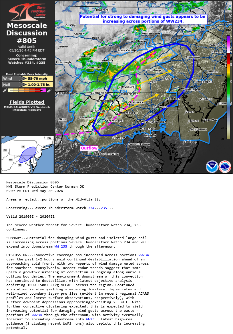
WPC issued meso for heavy rain and isolated flash flooding for the STW area
-
Areas along the Fredrick cells might need a flash flood warning with the training motion if they don’t collapse on themselves.
-
Whiteout rain with some hail mixed in.
-

2026 Mid-Atlantic Severe Storm General Discussion
batmanbrad replied to Kmlwx's topic in Mid Atlantic
SPC issued another MD for our area, seems to indicate things are continuing to ramp up somewhat: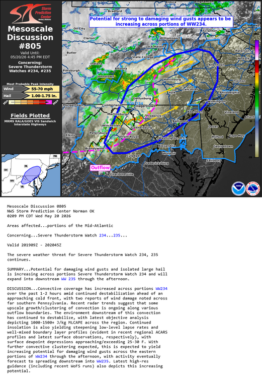
- 373 replies
-
- 1
-

-
- severe
- thunderstorms
- (and 7 more)