All Activity
- Past hour
-

Central PA Winter 25/26 Discussion and Obs
Itstrainingtime replied to MAG5035's topic in Upstate New York/Pennsylvania
Penn State's loss to Indiana is looking really impressive in hindsight. -
laughing my butt off. some funny stuff here tonight. we need a storm....
-

January 2026 regional war/obs/disco thread
UnitedWx replied to Baroclinic Zone's topic in New England
Very high could mean all the IPAs that have been flowing here this afternoon... I'm looking forward to seeing if this time frame can produce. At least there's something to track at least for now -
Prayers for your Mom and family Powell.
-

January 2026 regional war/obs/disco thread
40/70 Benchmark replied to Baroclinic Zone's topic in New England
"Very high" in terms of confidence that it will snow, or "very high" in terms of the perceived ceiling.... -
The only time I really ever watched JB videos is when he did "Point, Counter-Point" on AccuWeather. I can't remember the name of the other Met that would do the videos with him. I believe he died at a fairly young age from some sort of ladder accident. Does anyone remember the name of the other met on "Point, CounterPoint". I actually thought that his points were better than JB's.
-

Pittsburgh/Western PA WINTER ‘25/‘26
Rd9108 replied to Burghblizz's topic in Upstate New York/Pennsylvania
Agreed. Cold and dry does nothing but cause my bill to go up. -
Record high of 55 at 1159 last night and record high of 56 at 1258 this morning. The rare double daily records within an hour
-
You know that I know that you know that we're going to be tracking the cape storm and it's legit. You can keep being modest now, that's why we love you. But you know that I know that you know.
-
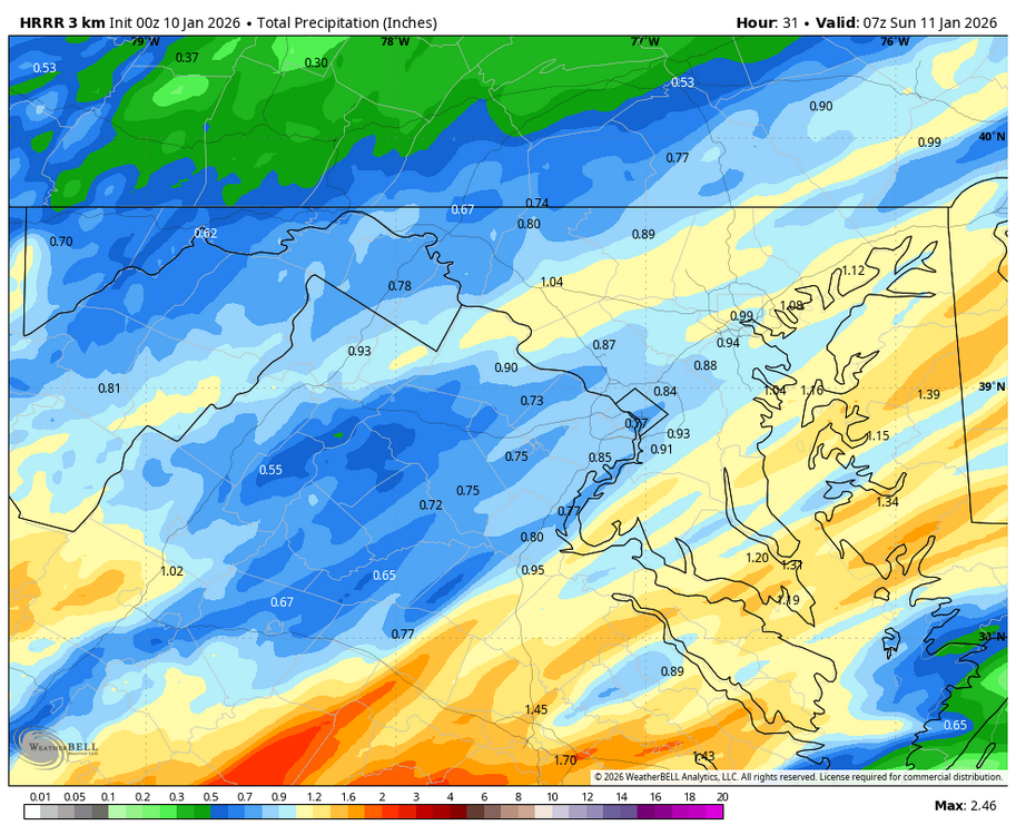
WB 0Z HRRR much wetter than 18Z. At least some much needed moisture on the way....
-
Look at @wncsnow being all positive. Maybe it’s some kind of reverse jinx. [emoji16] If the Panthers win tomorrow, I might believe that uncommon, irrational events — like a snowstorm in the foothills — might actually happen again. .
-
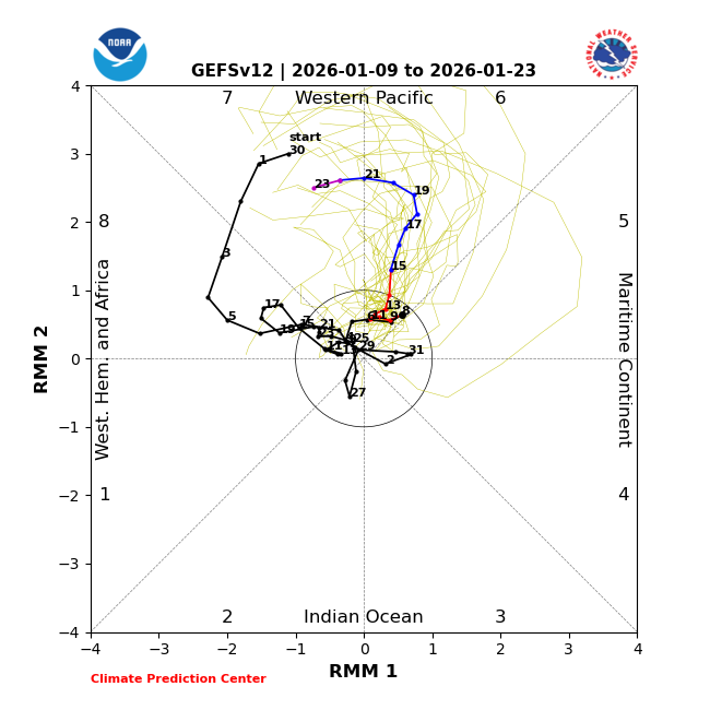
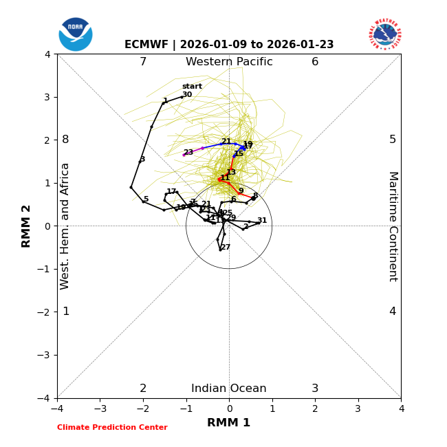
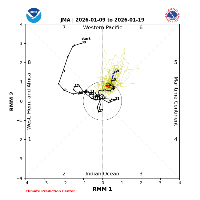
The models are unanimous in progging a 13+ day long phase 6 (1/9-21+). All that’s needed to have a record long Jan phase 6 is for it to be 12 days. This is consistent with phases 6-7 having had by far the largest # of days in Jan since 2011 (101, 104). OTOH, the # of Jan phase 8/1/2 days since 2011 has been only 42/17/26 days! GEFS has a 2.75 amp peak but it often is too strong: Looking ahead to Feb, phase 7/6 had 134/77 days since 2011 with 8/1/2/3 much lower at 41/30/32/35.
-

January 2026 regional war/obs/disco thread
moneypitmike replied to Baroclinic Zone's topic in New England
Good write-up from GYX for tomorrow night/sunday KEY MESSAGE 3 DESCRIPTION... Low pressure moves through the Great Lakes Saturday night, as a second low develops in the Gulf of Maine late Saturday night and Sunday. The first low brings warm air in aloft, while the coastal low helps brings colder air southward at the surface Sunday morning. Like we have seen several times so far this winter, cold air damming will help to drive temperatures and precip types through the event. With the NBM`s reliably poor performance through these systems, the forecast heavily weighted the available high res guidance, most notably from the Nam 3km. As the HRRR becomes more available through the system, there is likely room for continued refinement of temperatures into the day on Sunday. The set up overall is not as ideal at CAD set up as we have seen from other systems this winter. Saturday`s highs are mild with temps in the low to mid 40s, and precip arrives too early in the evening to allow for any meaningful radiational cooling. This means we`ll have to rely on wet bulbing and cold air advection for the colder temperatures. It`s pretty uncommon to wet bulb below freezing into sleet in freezing rain. For this reason, along much of the coastal plain and southern New Hampshire it`s likely to be in the 32-34 degree range with rain for much of Saturday night. Just north of this area, temps are likely to be at or just below freezing to produce a narrow stripe of sleet and freezing rain. Then north of here through the mountains and foothills, mainly snow is expected. This is the anticipated outcome through Saturday night. Then by daybreak Sunday, temperatures begin to fall as the coastal low deepens and winds shift to northerly. Colder air is expected to slosh southward at all levels of the atmosphere as the low deepens. This transitions precip to mainly rain or snow Sunday morning, with the rain/snow line moving southward. Precip likely runs out before the cold air arrives through the Seacoast as the dry slot moves in, but a period of snow likely ends the event through much of coastal Maine. Further north through the mountains, foothills, and across central Maine, moisture likely continues to blossom through the day as the coastal low deepens. Through these areas, there is an increasing potential for advisory level snowfall through the event. -

January 2026 regional war/obs/disco thread
Modfan2 replied to Baroclinic Zone's topic in New England
46F and rain, .10” so far. At least the salt is being washed off the roads -
The foothills drought is just as real as my 3.1 inches. Just to help you keep it in perspective
-

January 2026 regional war/obs/disco thread
HoarfrostHubb replied to Baroclinic Zone's topic in New England
There was pretty much zero wind when I walked the dog around 4. This seems to have started after 7:30 or so. -
High of 75 after a low of 44.
-

January 2026 regional war/obs/disco thread
dendrite replied to Baroclinic Zone's topic in New England
We calm -
It's 10 days out, it could still be nothing for all of us.
-
January 2026 regional war/obs/disco thread
HoarfrostHubb replied to Baroclinic Zone's topic in New England
Windy tonight. -
my area got to 61 before sunrise, breaking a record of 59
-
Transient 50-50 lows are often not helpful outside of perfect timing/luck. Its simply a low moving through that location. A 50-50 low that is useful is part of a -NAO rex block, in which case it is quasi-stationary.
-
Been wondering about this...considering the lag in atmospheric effects we see, would we see a response that soon?
-
He's clearly going off today's Euro weeklies that could easily be substantially different in a few days. Fwiw, 18z Gefs are cold to end the run still.