All Activity
- Past hour
-
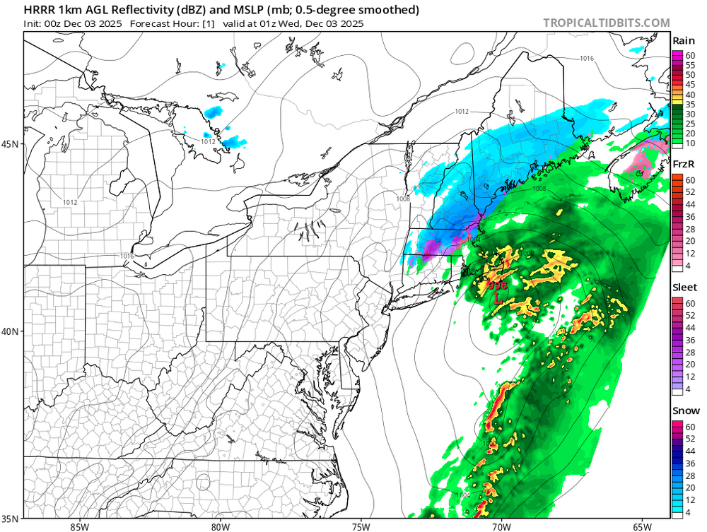
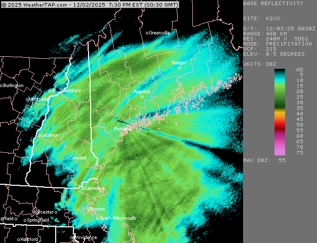
Models can't initialize this storm to save their life. The hrrr is completely missing the big band over Northern Vermont. Pretty garbage model performance all around, from the medium to short terms
-
About 4.5”. I don’t do the ratio stuff but it is pretty fluffy. 22°
-

December 2025 regional war/obs/disco thread
TauntonBlizzard2013 replied to Torch Tiger's topic in New England
Temps look to be an issue -
I was a little confused by your question, so I had to reread a few times. Correct me if I’m wrong, but I think what you are asking is why the low doesn’t develop right under the strongest winds of a jet stream. You’d be correct in your observation that it usually develops downstream of a trough where upper level winds diverge, air lifts, and surface pressure decreases. When the vorticity “stretches”, we get an elongated region of positive vorticity advection as opposed to concentrated into a tight vort max over one area. That spreads upper level forcing for lifting over a large area, thereby “diluting” the tendency for a surface low to form. So it’s not so much the sfc low doesn’t “prefer” to be away from the strongest winds, but more like it tends to deepen where that elongated band of vorticity overlaps the divergence (left exit/right entrance regions) and the baroclinic gradient. The displacement you’re noticing is really a reflection of where the total forcing (vorticity and upper level divergence) both line up, which often ends up a bit downstream and to the left of the jet streak, not directly under the strongest winds. Now when the jet core “rounds the base” of the trough, you’re right that we’re often getting into the mature phase of the storm. By that point, the upper level trough and the surface low have gotten more vertically stacked, and the low begins to occlude and weaken. Sorry if this got too technical, but your question covers several different meteorological concepts, and the evolution of a cyclone where conditions differ between the early stages of development and when it matures.
-
A back edge additional dusting of snow. 31/29
-

Central PA Fall Discussions and Obs
Jns2183 replied to ChescoWx's topic in Upstate New York/Pennsylvania
The markets have it a neck and neck race between Jeff Brohm and Terry Smith Sent from my SM-S731U using Tapatalk -
 Currently at 32F which is my high for the day. We definitely have a decent glaze on everything and I anticipate lots of ice in the morning on driveways and sidewalks. Total snow was 1.5" +/- before the changeover to sleet and freezing rain. Careful out there.
 -
About 1.3” rain.
-
Central PA Fall Discussions and Obs
Jns2183 replied to ChescoWx's topic in Upstate New York/Pennsylvania
That did shovel like lead Sent from my SM-S731U using Tapatalk -
12/2- Big fat goose egg
-
SWfE usually have a primary well west and ripping srly flow aloft where the 800-700 layer causes sleet. Tbis is just a weird one.
-
Really effing weird. Sfc low almost got elongated too to the northeast. Yet we had 925 taking forever to close off and ripping from 180-170.
-

2025-2026 Fall/Winter Mountain Thread
Maggie Valley Steve replied to Buckethead's topic in Southeastern States
Snow flurries in the Valley. It's starting to stick on the deck and vehicles. 31 and no wind. -
Very light snow flurries and 29 F here...gusts in the 20s.
-
Just happened to turn on The Weather Channel and Paul Goodlow was live from Poughkeepsie. Had some snow squalls come through and whiten the ground. .
-
Some light rain/snow mix in Asheville. 35.
-
I said late last week, would this be a sort of hybrid(half coastal, half SWFE), and I believe it was determined at that point that it would be a coastal. But in the end now…it wasn’t quite a true coastal it seems. Interesting. The cold was never scoured out here…that’s rare when you have warming like that 950.
-
We've been missing the heaviest snows but make no mistake, winter has set in early this year! Single digits on the way Thursday night. Took this this evening as the moon made the snow glisten.

-

Central PA Fall Discussions and Obs
Blizzard of 93 replied to ChescoWx's topic in Upstate New York/Pennsylvania
I ended up with 3 inches of snow & sleet in Marysville that were compacted into cement by the time I shoveled this evening. This stuff was heavy & provided quite a workout. My back is barking already! -
Been seeing some flurries here as well this evening.
-
You sure its not 17" in Lunenburg?
-
Some of the heaviest rates on the day about to move over the area as SPC has issued a bulletin for 1/2-1"/hr rates.
-
Reports of 7” in Fitchburg and Lunenburg
-

2025-2026 Fall/Winter Mountain Thread
Buckethead replied to Buckethead's topic in Southeastern States
21 and still falling in Wolf. Picked up just over an inch now. It's bright outside tonight! Sent from my SM-S908U using Tapatalk -
Just a cold, wind driven rain event here..nothing out of the ordinary for early December in these parts. Beautiful pics from the snowbirds to the far north. The fluffy powder really does brighten things up this time of year.