All Activity
- Past hour
-
We will still see snow. Will it amount to much? Who knows. It’s a race against rising temps. Snow on 12/2 is exciting all the same.
-

12/3 Snow/Sleet/Mix Bag of Everything Discussion/OBS
Hurricane Agnes replied to Mikeymac5306's topic in Philadelphia Region
This setup in January or February would have had quite a few cashing in, with some possible overrunning closer to the coast. But it's still early in the season and the water is "warm" (and the low is supposed to be coming out of the warm Gulf). If the low moves further to the east, some of the colder air could mix in and bring the R/S line further east. -

Central PA Fall Discussions and Obs
Mount Joy Snowman replied to ChescoWx's topic in Upstate New York/Pennsylvania
Hey, do either of you know, for that mini event yesterday morning, did it stay as all snow/sleet or did it end as a period of plain rain? Trying to keep the books accurate haha. Thanks. -
How are the cherry blossoms doing?
-

First Winter Storm to kickoff 2025-26 Winter season
CoastalWx replied to Baroclinic Zone's topic in New England
Reggie warmed 925 into SNH. Lousy trends at 12z. -
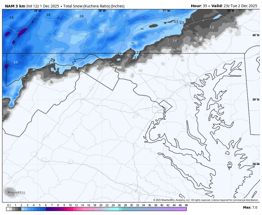
WB 12Z 3K NAM...our first Lucy of the season!!!!

-
You forgot to mention how it still managed to change to sleet over JI's house and he only gets 2-4"
-
Welp, looks like I’ll need to drive up Hamburg Rd again to see snow. 1k ft elevation is the new 500.
-
Final Call for entries and revisions. When the clock strikes midnight (EST) on Monday evening, the entry deadline will be closed. Speaking of which, here is my entry: BWI: 8.2 DCA: 6.7 IAD: 9.4 RIC: 8.2 ----- SBY: 6.7
-

First Winter Storm to kickoff 2025-26 Winter season
ORH_wxman replied to Baroclinic Zone's topic in New England
ICON warmed a good bit too...not as crazy as NAM, but a solid tick. 12z runs are definitely seeing something so far. RGEM looked a little warmer too, but a very small amount vs 06z. -

Central PA Fall Discussions and Obs
Itstrainingtime replied to ChescoWx's topic in Upstate New York/Pennsylvania
Same thoughts I have. I'm not confident I'll reach 2" but .5"-2" seems reasonable. The last minute north trend on models has begun, at least on some modeling. -
Update Dec 1
-

First Winter Storm to kickoff 2025-26 Winter season
Lava Rock replied to Baroclinic Zone's topic in New England
go take another run -

First Winter Storm to kickoff 2025-26 Winter season
weatherwiz replied to Baroclinic Zone's topic in New England
The overall differences between NAM/Euro/GFS seem rather subtle but these subtle differences have significant ramifications into how this unfolds. All kind of seems to be tied into exactly where/when the sfc low becomes more defined and where/when 925/850 lows develop and close off. Of course, there is still the signal in the potential for dual lows. Regardless, this will be a nice hit from parts of Maine through central NH, southern VT and into western MA. Also wondering if we see a secondary smaller max from like Worcester into SE NH -
I believe its a function of not living through the lean years prior to 2000. People expect the bonanza of snowstorms during that time and get frustrated when we regress back to the mean.
-

Occasional Thoughts on Climate Change
WolfStock1 replied to donsutherland1's topic in Climate Change
Bingo. chubbs and donaldsutherland1 don't seem to understand that "subsidies" and "costs" are not the same thing. You can't just lump them in together like that. If you're going to do that - you also have to include "benefits". Not doing so simply invalidates the argument. It's an attempt to distract from the actual argument, which is explicit subsidies. That is a valid discussion, and the data clearly shows that renewable energy receives far more subsidies than fossil-fuel energy. -

First Winter Storm to kickoff 2025-26 Winter season
HoarfrostHubb replied to Baroclinic Zone's topic in New England
I just found out about it yesterday. At least it is on Pivotal -
One slight bright spot is the AO is finally starting to drop, but the PNA sucks.
.thumb.png.82356425c93448d69cb2012897b16446.png)
-

First Winter Storm to kickoff 2025-26 Winter season
SouthCoastMA replied to Baroclinic Zone's topic in New England
It's more like this -

First Winter Storm to kickoff 2025-26 Winter season
Snowcrazed71 replied to Baroclinic Zone's topic in New England
Okay, let's see! -

First Winter Storm to kickoff 2025-26 Winter season
Typhoon Tip replied to Baroclinic Zone's topic in New England
One would think the models are physically handling this ... but there's an almost nondescript cold front and associated 'bubble' high over lower Ontario and Upstate NY ... DPs in that region are < 20F ... with temperatures about 10-15 F colder. It's moving this way. It may prove important as an antecedent prep for this thing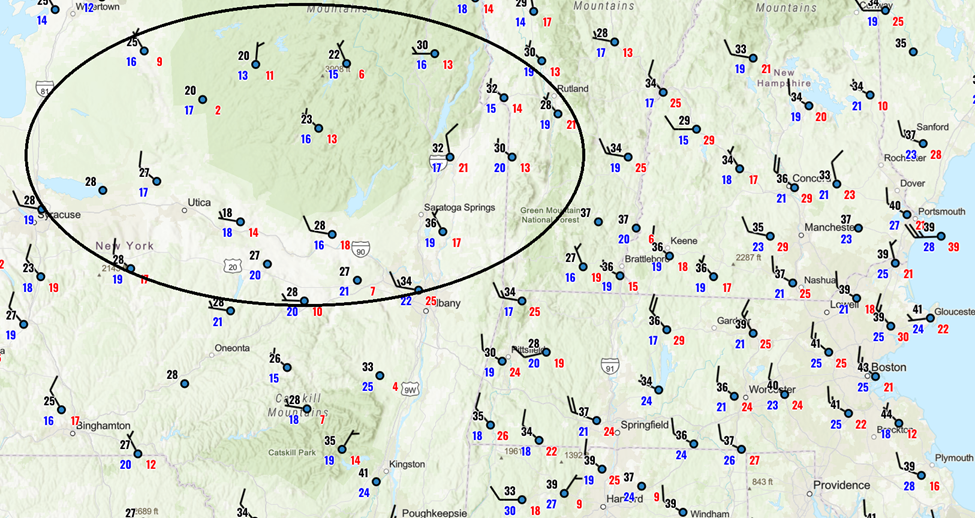
-
First Winter Storm to kickoff 2025-26 Winter season
PowderBeard replied to Baroclinic Zone's topic in New England
Im surprised no weenie in the 495/128 area has posted the HRDPS yet. When ye ole herp gets posted, you know a good one is on the way. -

2025-2026 Fall/Winter Mountain Thread
WeatherHawk replied to Buckethead's topic in Southeastern States
Welcome and thanks for your service! It's a good crew here. My daughter lives in Southport and I'm sure you can chat about the crab cakes at Provisions...anyway welcome aboard. Glad to have you here -

12/3 Snow/Sleet/Mix Bag of Everything Discussion/OBS
Duca892 replied to Mikeymac5306's topic in Philadelphia Region
annndddd this is starting to dwindle a bit as we come closer to game time lol -
 Nice event there and interior Massachusetts


.png.2aba82d76d9a5a02c1376403455ba699.png)

