All Activity
- Past hour
-

Jan 24-26 Weekend Snow and Sleetfest Model Thread Part Tres
GreyHat replied to H2O's topic in Mid Atlantic
There is one already -
-

Southern Crippler - Get well soon Jimbo Storm Obs
Summey replied to BooneWX's topic in Southeastern States
27.3°/11° -

Jan 24-26 Weekend Snow and Sleetfest Model Thread Part Tres
dailylurker replied to H2O's topic in Mid Atlantic
Could we get an observation thread? Those of us that are trying to obsess over every NAM run don't care what your temp is lol -

Extreme Cold, Snow & Sleet: SECS 1/25 - 1/26
SnoSki14 replied to TriPol's topic in New York City Metro
I think pretty much everyone will see 7-8" with the thump. The wall of snow to sleet idea is playing out as expected. Now it's just about timing. The longer we hold off the transition, the more snow we get. Even a 2-3 hr delay could mean the difference between 7" and 10"+ -

“Cory’s in LA! Let’s MECS!” Jan. 24-26 Disco
Twitching Trucks replied to TheSnowman's topic in New England
Over on the ME border 20 miles off the coast, this is the yup of set up that we do very well with. Coastal influence encroaching generally up to our doorstep gets us something banding and if we can keep P-type issues at bay, the snow stacks up. The slogging easterly flow snow Monday also adds up here with a little OE influence, and that tends to keep up all the way over toward CON, close to you. I think we’ll do well. . -
Only made it to -14F here which is pretty common on a good radiational night and quite far from our seasonal low of -29. The fact that it snowed a good chunk of the night probably had something to do with it...
-

Jan 24-26 Weekend Snow and Sleetfest Model Thread Part Tres
LeesburgWx replied to H2O's topic in Mid Atlantic
5 here right now. Hoping to get below zero Monday night -

1/23/26-1/25/26 Winter Storm Thread
Holston_River_Rambler replied to AMZ8990's topic in Tennessee Valley
MRX updated their ice accretion forecast about an hour ago: -

Pittsburgh/Western PA WINTER ‘25/‘26
Gordo74 replied to Burghblizz's topic in Upstate New York/Pennsylvania
I'm near that initial 20" map posted by Colonel last night, but I'm not buying it yet. I hope it's true, but at this point, I think double digits (10"+) is what I'm hoping for. Also, a habit I picked up from when we had the wet blanket - once the event starts, I won't be back on the forum until after the event. It's fun to track with you all, but I want to enjoy the event for what it is rather than obsessing over wiggles in the radar 30 miles west praying it doesn't shut off. Best of luck to you all - catch you on the flip side. -
 -1.3 still falling
 -

January 25-26 Winter Storm Potential
Birds~69 replied to Ralph Wiggum's topic in Philadelphia Region
I'd be surprised if we received anything <6"... Cold/crisp out there 6F -

Extreme Cold, Snow & Sleet: SECS 1/25 - 1/26
Stormlover74 replied to TriPol's topic in New York City Metro
Doubt it means much for us but sounds like snow is underperfroming in ok and KS. But they're getting a 2nd round tonight -
I was about to ask. Is the air really that much drier in the basin? I get higher dewpoints to the south and why it would start at higher elevations.
-
Got it. Thank you PF! Interesting stuff. Looks like we finally cleared out sometime overnight after a few more inches of snow. With all the talk of cold, though, we only got to -14F which is pretty common on a good radiational night and quite far from our seasonal low of -29.
-
“Cory’s in LA! Let’s MECS!” Jan. 24-26 Disco
Damage In Tolland replied to TheSnowman's topic in New England
The RRFS had it -
Don't forget, we have an Obs Thread. Not to say that you can not post them here, but for the sake of a clean thread, it would be good to transition those posts to the other location.
-

Jan 24-26 Weekend Snow and Sleetfest Model Thread Part Tres
LP08 replied to H2O's topic in Mid Atlantic
Only 9 after a high yesterday here of 45. Quite a shock to the system! -

Arctic Hounds Unleashed: Long Duration Late January Cold Snap
dendrite replied to WxWatcher007's topic in New England
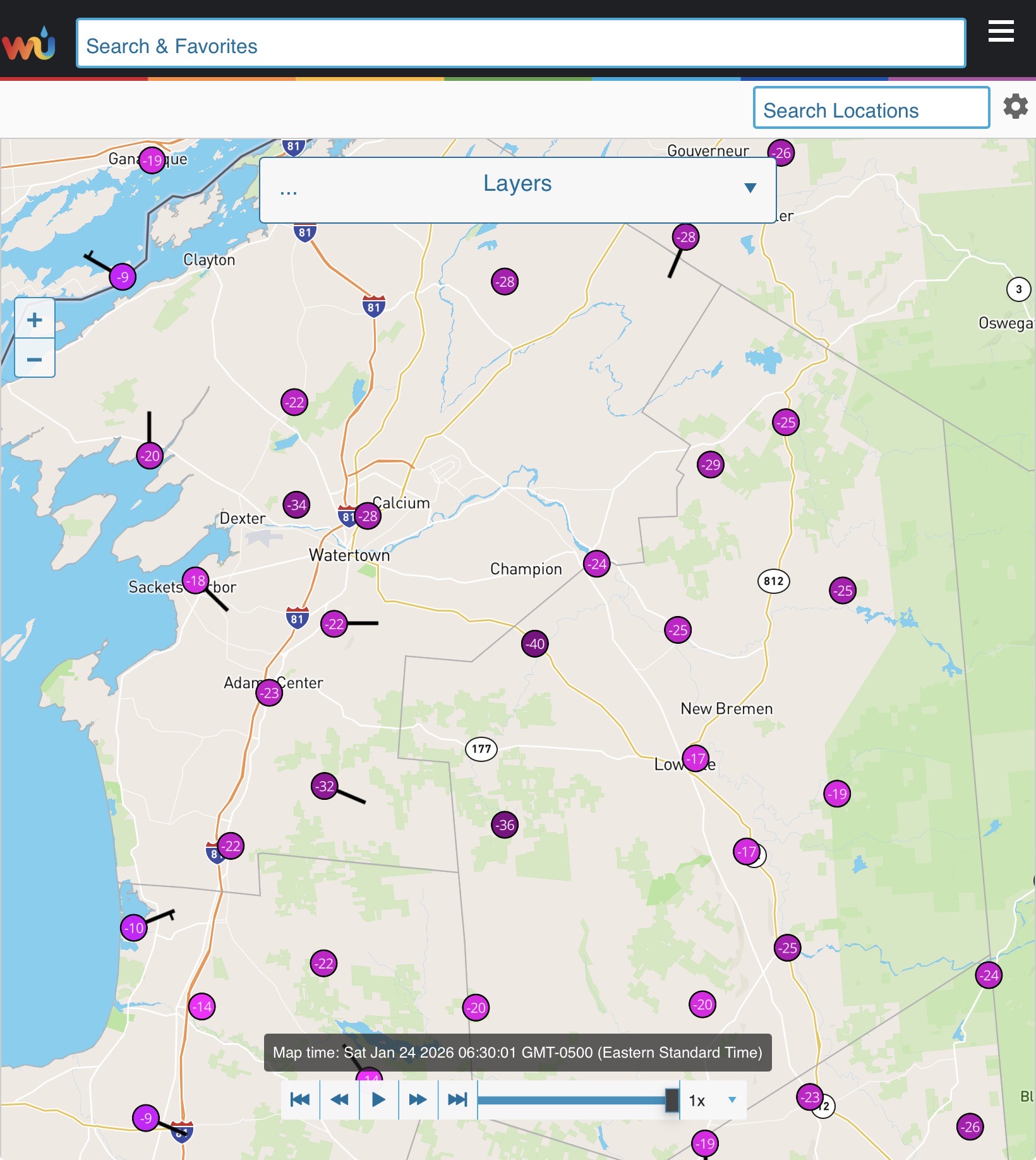
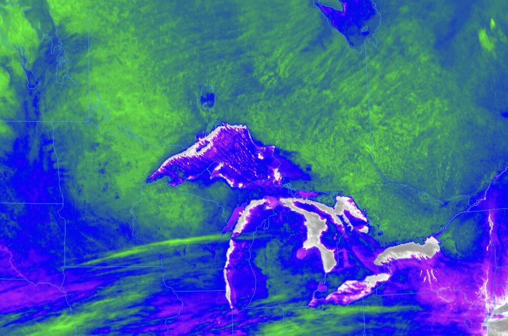
-40° in Copenhgen NY You can see the -30s to -40 pretty clearly across MN, WI, MI, ON, NY on IR radar as the snow surfaces show up green on this image.
-

Winter 2025-26 Medium/Long Range Discussion
Jackstraw replied to michsnowfreak's topic in Lakes/Ohio Valley
Read an article that the snowpack is 75% below average and if it doesnt improve they may have to shut down the generators an Glen Canyon Dam. Yikes! -
6z Ukie a little south and continues better for Monday. I wish I could trust it.
-

Pittsburgh/Western PA WINTER ‘25/‘26
Rd9108 replied to Burghblizz's topic in Upstate New York/Pennsylvania
Odd I fully expected to wake up and look at the 6z runs and get pissed. Ive been hurt in the past... -

Extreme Cold, Snow & Sleet: SECS 1/25 - 1/26
East of the Parkway replied to TriPol's topic in New York City Metro
That 3-6 line likely edges it's way up costal Monmouth East of Rt 35. -

January 24-26: Miracle or Mirage JV/Banter Thread!
WxUSAF replied to SnowenOutThere's topic in Mid Atlantic
Rates have gone way up. And for reasons I don’t understand, other suppliers have totally pulled out of the market. -

Jan 24-26 Weekend Snow and Sleetfest Model Thread Part Tres
CAPE replied to H2O's topic in Mid Atlantic
Lovely to wake up and read this from Mt Holly The narrow corridor of highest ice accumulations has shifted southeast, now focused over South Jersey, central Delaware, and the Eastern Shore of Maryland.