All Activity
- Past hour
-
Ripping up here as storms train through. I've already blown past an inch and counting just in the last 20-25 minutes. Frequent thunder and lightening.
-

E PA/NJ/DE Summer 2026 Obs/Discussion
Lady Di replied to PhiEaglesfan712's topic in Philadelphia Region
Risk for severe weather went from a 2 to 3. Yikes. I have somewhere to be a 5pm and hope I can get home before any rough stuff, but seems I could be driving in it. At least I don't have far to go. Weather Story from NWS Philadelphia/Mt Holly -

Central PA Summer 2026 Discussion/Obs Thread
Itstrainingtime replied to Voyager's topic in Upstate New York/Pennsylvania
Hoping for rain but not much else. I only received 0.09" over the weekend and with a dry spell inbound I'm hoping for something appreciable today. -
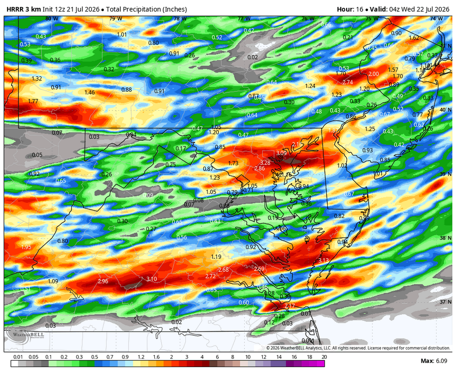
WB 12Z HRRR thru today.
-

2026-2027 Super El Nino
mitchnick replied to Stormchaserchuck1's topic in Weather Forecasting and Discussion
My mistake Larry. Sorry. Still, I contend the AN forecast in 23/24 from the Cfs2 was not bad as it was on the correct side of normal for the east+ and got warmer as the season approached. -
Clouds. Our most common failure mode. Hope we can clear out today.
-

2026-2027 Super El Nino
bluewave replied to Stormchaserchuck1's topic in Weather Forecasting and Discussion
Some extreme effects from this record developing El Nino showing up in South America. -
2026-2027 Super El Nino
mitchnick replied to Stormchaserchuck1's topic in Weather Forecasting and Discussion
Without going into a competing long response, I frankly just don't care about a warming planet. There's nothing I can do about it aside from having a well insulated home (which I have since I receive the highest rating from my local energy provider for houses my size) and driving a fuel efficient vehicle. It is not, nor has it ever been, on my list of life's concerns at all. I care about weather imby and judge that weather from current conditions and progs. How those conditions got there, I don't care. -

Central PA Summer 2026 Discussion/Obs Thread
TheDreamTraveler replied to Voyager's topic in Upstate New York/Pennsylvania
Had a decent tiny thunderstorm around 3 am that popped up. Wasn't really expecting any rain -

2026-2027 Super El Nino
40/70 Benchmark replied to Stormchaserchuck1's topic in Weather Forecasting and Discussion
Guessing Feb 2015 was the one top-ten coldest. I wish we would focus a bit more on temp maxes instead of mean because I feel like the nocturnal element does inflate the degree of impact somewhat. I don't really care if its 21 on RAD nights instead of 18....I care how warm it is during the day and when it's precipitating. Don't get me wrong....I know it's warming, I'm not trying to steal anyone's climate change, but it's warming the most on clear nights and the days/stormy nights are most relevant to us. -
The wind is already blasting onshore at jones beach, so we are going to have instability issues here. .
-
Its really looking cool and wet the next couple weeks. The Euro remains below average through early August after a few more days of heat.
-
a few peeks of sun out here north of Winchester but not much yet. Is that garbage out in Northern Ohio supposed to be our main show?
-
1300z SPC OTLK has moved the ENH southern line south to RIC... was near EZF on 06z outlook
-
Yeah 11z hrrrr seems like a winning scenario for most everyone
- 1,227 replies
-
- 2
-

-
- severe
- thunderstorms
- (and 7 more)
-
Day 1 Convective Outlook NWS Storm Prediction Center Norman OK 0757 AM CDT Tue Jul 21 2026 Valid 211300Z - 221200Z ...THERE IS AN ENHANCED RISK OF SEVERE THUNDERSTORMS ACROSS PARTS OF THE OHIO VALLEY TO MID-ATLANTIC STATES... ...SUMMARY... Numerous severe thunderstorms are expected across a broad region from the Ohio Valley to the Mid-Atlantic and Northeast States today into tonight. Swaths of damaging wind gusts are expected to be the most common impact, but some tornadoes are possible as well. ...Ohio Valley into the Mid-Atlantic and Northeast... A broad area of 40-50-kt mid-level west-southwesterly flow will overspread the Ohio Valley into the Mid-Atlantic/Northeast as a large-scale trough amplifies and shifts across the northeastern CONUS. Scattered to numerous thunderstorms are expected to develop ahead of an eastward-moving cold front across the Ohio Valley and along a pre-frontal trough over the Mid-Atlantic. In the base of the trough, a convectively augmented mid-level impulse moving from the lower Ohio Valley into the Mid-Atlantic may also serve as a focus for convective development. Severe thunderstorm potential could increase relatively early today across parts of Ohio into Pennsylvania and western New York. Diurnal heating within cloud breaks, combined with upper 60s to lower 70s F dewpoints, will support at least moderate surface-based instability across the broad pre-frontal warm sector. The most favorable overlap of this instability and 40-50 kt of effective shear is expected from the lower Ohio Valley into the Mid-Atlantic, where a mix of organized clusters and supercells should evolve and spread eastward through the day. Swaths of damaging wind gusts will be the primary severe hazard, though severe hail will also be possible with any initial/sustained supercells. Additionally, a gradually strengthening and expanding 30-kt low-level jet will contribute to clockwise-curved low-level hodographs, and a few tornadoes may occur. This supercell related-tornado potential may focus along the warm front into parts of the Northeast, and with semi-discrete development later today focusing along the lee trough/edge of higher terrain, although low-level shear/SRH will be moderate in most of the open warm sector as well.
-
 Same here. I feel like I didn't even really get to enjoy the summer. I regret not setting up shop outside and working like I did the past few summers. But I got myself one of those towers with 3 monitors hooked up and it would have just been a pain to bring that outside each day/inside and then the power strip. But its been work/summer classes so haven't been able to do much. I try and sit outside during the evenings but we get destroyed with mosquitos.
 -
Sun is out in Charlestown wv at my work.
-
Same here. I think our show is at 7:00 in Frederick. Hopefully everything passes before then.
-

2026 Mid-Atlantic Severe Storm General Discussion
high risk replied to Kmlwx's topic in Mid Atlantic
Heating is obviously a concern, but assuming we bust out into some partial clearing by late morning, HRRR and RRFS both have a couple of interesting lead cells followed by a squall line feature.- 1,227 replies
-
- 1
-
-
- severe
- thunderstorms
- (and 7 more)
-
 Maybe it's just me but this summer seems to have flown by.
 -
Already dealing with the later sunrises and the earlier sunsets are getting noticeable too, it blows.
-
The soon to be retired Nam.
-
I would roll the dice and drive down. Heavy cloud cover here. I always take the under when I wake to cloud cover. Not saying strong storms are not possible, but as stated above I don’t feel it will be as widespread as if we woke to hot hazy clear skies. Disclaimer: I’m not a met. But I am an enthusiast that’s lived here 40 of my adult years. .
- 1,227 replies
-
- 1
-
-
- severe
- thunderstorms
- (and 7 more)
-

2026-2027 Super El Nino
GaWx replied to Stormchaserchuck1's topic in Weather Forecasting and Discussion
The -SOI streak just hit 72 days, which is tied with 1997 for the 2nd longest -SOI streak since the daily record start in 1991! There’s a near 100% chance that it will reach a new 2nd longest streak of 73 days tomorrow: https://data.longpaddock.qld.gov.au/SeasonalClimateOutlook/SouthernOscillationIndex/SOIDataFiles/DailySOI1887-1989Base.txt