All Activity
- Past hour
-
-
First Winter Storm to kickoff 2025-26 Winter season
mahk_webstah replied to Baroclinic Zone's topic in New England
A rapidly intensifying coastal storm can certainly have a heavy band even if moving quickly. I’m talking 1-2”/hour -

Pittsburgh PA Fall 2025 Thread
Mailman replied to TheClimateChanger's topic in Upstate New York/Pennsylvania
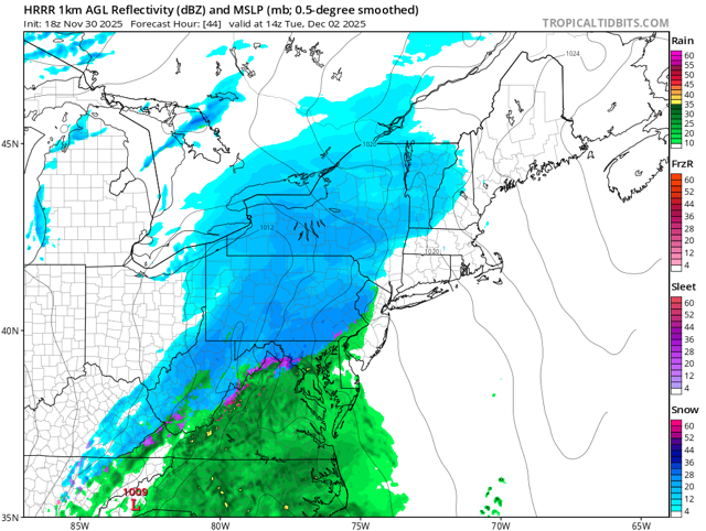
Most models and ensemble solutions have come into agreement more closely on the precise low track through coastal GA/SC and directly up the East Coast, positioning us on the far northern edge. This track places the transition zone along and south of I-70 and along and east of the Ohio river. Areas north and west of this have a better shot to remain all snow and therefore have a higher chance of seeing 2-4" snowfall totals. South and east of this, precip types may be an issue for snowfall accumulation with a wintry mix more likely in this region. Probabilities for Advisory level snow have climbed across much of the region (save for the Mon Valley) compared to 24 hours ago. Probabilities for Warning level snow remain largely between 10-20% at their highest. Snowfall rates of 1"/hour seem possible in the heaviest snowfall, likely during the predawn hours of Tuesday morning. These rates peak in several stripes running SW to NE across the region, highlighting embedded heavier bands in the stratiform snow. Neighborhood probabilities for 1"/hour rates peak as high as 60-80% in SE Ohio near the I-70 corridor, but are at least 20-30% across much of the region. Stout 850mb WAA racing up the spine of the Appalachians points towards the possibility of freezing rain in the Mon Valley and eastern ridges early Tuesday morning. These chances remain highest in our WV ridges, where the best WAA will be. Further west towards the Ohio river, there could still could be freezing rain if the WAA over performs but current model soundings point towards a period of melting snow or sleet. Ice accumulations of a glaze up to a few hundredths could be possible by Tuesday morning, highest in the WV ridges. At this time a Winter Weather Advisory looks likely for much of the area for accumulating snowfall and then perhaps another in the ridges for possible ice. We could end up in a situation where the only areas that do not need a Winter Weather Advisory would be portions of the Mon Valley, where snowfall totals will be kept in check by low SLRs/rainfall and freezing rain chances are lower than just east in the ridges. No matter the headline decision, the Tuesday morning commute could be a messy and potentially dangerous one across the region. Please allow for extra time to reach your destinations and we urge extra caution on area roadways. -

First Winter Storm to kickoff 2025-26 Winter season
moneypitmike replied to Baroclinic Zone's topic in New England
Hanging your hat on the NAM 2 days out is a risky venture. Anyway--here's my p/c. Hoping the tuesday night numbers pad the day time totals a lot. Tuesday Snow, mainly after 9am. The snow could be heavy at times. High near 36. Calm wind becoming west around 5 mph in the morning. Chance of precipitation is 90%. New snow accumulation of 3 to 5 inches possible. Tuesday Night Snow, mainly before midnight. The snow could be heavy at times. Low around 22. Chance of precipitation is 80% -
Colder airmass to start so yes I agree though similar setup to Tuesday with high escaping. Will depend on storm track Unfortunately think majority of snows occurs NW of our region. SNE and north will do really well. Borderline for NYC
-
0.11” so far 11/30/25 1.63” for November
-
Regardless of whether he is intentionally trolling the negativity gets old. He’s not the only one. .
-
Are you completely ignoring the MJO? That's well-established data. We have seen modeled torches evaporate as we approach go-time. Trends are pointing to a great December. Now, all that could change, but right now, you are just being negative for the sake of disagreement.
-
November 2025 general discussions and probable topic derailings ...
dryslot replied to Typhoon Tip's topic in New England
We flipped to rain here. -

First Winter Storm to kickoff 2025-26 Winter season
mahk_webstah replied to Baroclinic Zone's topic in New England
GYX seems to be saying that the nam could be signaling a heavy meso band in the interior coastal plain -
Can someone post the Eps AI snowfall total for the entire run? I have Pivotal and for some reason doesn't have snowfall amounts from that one despite the other info. Maybe it doesn't want me to go blind, idk. Anyway, Tia.
-

December 2025 regional war/obs/disco thread
H2Otown_WX replied to Torch Tiger's topic in New England
Seems we lost the weekend threat. Maybe 1-3" or something but it isn't looking quite as potent. Always had the look of a quick changeover down here in the tropics anyway. Euro showing a couple threats beyond that as well. Should be a fun few weeks! -

E PA/NJ/DE Winter 2025-26 Obs/Discussion
penndotguy replied to LVblizzard's topic in Philadelphia Region
I’m not liking that, the Jackpot zone this early usually craps the bed, by tomorrow it’ll be quick shot snow then rain. Seen it all to often. -

November 2025 general discussions and probable topic derailings ...
dendrite replied to Typhoon Tip's topic in New England
Pushing a 1/2”. 29.9° Road is slick -
Latest (12Z/30) EURO OP is locked, loaded and ready to discharge a bitter cold Arctic outbreak into the Mid-West / Lakes and Northeast starting next weekend. Still time to work out the details on who gets how cold but reasonable confidence it is coming.
-

First Winter Storm to kickoff 2025-26 Winter season
H2Otown_WX replied to Baroclinic Zone's topic in New England
Could be wrong, could be right? No one knows? -
That model has not been good at the surface.
-

First Winter Storm to kickoff 2025-26 Winter season
Prismshine Productions replied to Baroclinic Zone's topic in New England
Work retail as an ASM at my Dollar Tree, kinda fucked this time of year time wise Sent from my SM-S166V using Tapatalk -
November 2025 general discussions and probable topic derailings ...
NW_of_GYX replied to Typhoon Tip's topic in New England
Looks like the mix line is in Naples/Sebago -
November 2025 general discussions and probable topic derailings ...
NW_of_GYX replied to Typhoon Tip's topic in New England
Still snowing here, hanging on at 32. Not sure we flip. Nice wintry vibe out there with the ground covered. -

First Winter Storm to kickoff 2025-26 Winter season
HoarfrostHubb replied to Baroclinic Zone's topic in New England
I tend to agree with that. But hoping it speeds up a little. Although a snow day this early in the season isn’t ideal. #conflicted and superintendents might read into this part of the watch: IMPACTS...Travel could be very difficult. The hazardous conditions could impact the Tuesday morning and evening commutes. -
Yeah that last inch or so on my driveway sublimated quickly.
-
First Winter Storm to kickoff 2025-26 Winter season
NW_of_GYX replied to Baroclinic Zone's topic in New England
First event of the season! My take: Euro is an outlier, not buying verbatim and expect to see that tick NW over the next 24 hours. Seems like that’s been a pattern for that model over the past few seasons. NAM is doing its overamped NW thing but beware those midlevels for CNE and SNE. I have a feeling congrats dendrite with this one which is typically good for me too. Happy winter everyone! -

Nov 28-30th Post Turkey Day Winter Storm
Jackstraw replied to Chicago Storm's topic in Lakes/Ohio Valley
Got 5 I'll call it to stay consistent with reports from around the area. Would have been a total bust if not for that late morning punch where we got half of that. Had nearly an 8-9 hour stretch with nothing in between. Both bookend periods were of higher quality powder than I expected. Lost an inch or so due to some melting, compaction and a small bit of drizzle around 3am. Got Pingers too for good measure lol. Not my best Nov snow but a top 5 in the last 15 years since I've been here. Sadly Nov '25 has tied my entire winter last year. Congrats to the final table up N and good luck to all over the next week. Me thinks a Dec warm up is not far away. Hopefully we are timing out for good holiday systems this year!


