All Activity
- Past hour
-
NE CT attracts the biggest weenies
-
Was there last September. Been to a lot of places, but Alaska def cracked the top 3. Add the Banff to Jasper corridor and New Zealand to your bucket list in terms of ridiculously beautiful locations.
-
Per Mesonet the VWC is 0.02 at the Ridgely station. Probably about the same in my yard.
-
(002).thumb.png.6e3d9d46bca5fe41aab7a74871dd8af8.png)
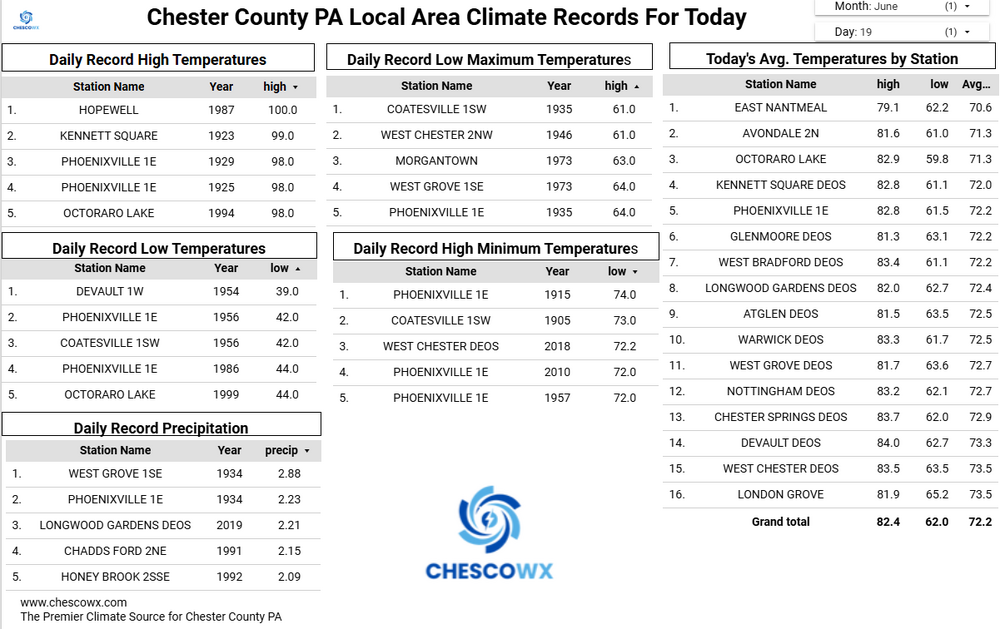
Central PA Summer 2026 Discussion/Obs Thread
ChescoWx replied to Voyager's topic in Upstate New York/Pennsylvania
Below normal temperatures for most of the next week with beneficial rains arriving for much of the area by late Sunday into Monday. Sun should return this afternoon with lower humidity. The weekend looks great with highs in the upper 70's to near 80 degrees and lows in the 50's. The rain Monday could be significant with most models painting as much as 1" to 1.5" of needed rain.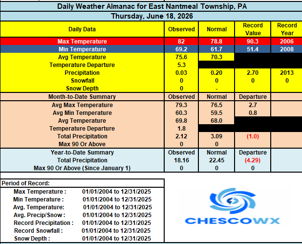
-
E PA/NJ/DE Summer 2026 Obs/Discussion
ChescoWx replied to PhiEaglesfan712's topic in Philadelphia Region
Below normal temperatures for most of the next week with beneficial rains arriving for much of the area by late Sunday into Monday. Sun should return this afternoon with lower humidity. The weekend looks great with highs in the upper 70's to near 80 degrees and lows in the 50's. The rain Monday could be significant with most models painting as much as 1" to 1.5" of needed rain.
-
We miss to the NW one day, and to the SE the next. At least the lower shore and SE DE will get a tiny bit of relief from the drought.
-
Not sure you can do 6hrs successfully with wind like that anyway. But I assume most of those obs were COOP. People measured like weenies back then too. What’s that 27” in NE CT? Sticks out like a sore thumb.
-
It’ll all fall on the 4th I’m sure
-
I would be shocked if July was above average rain
-
I think we’re done but what a great rainfall. 0.98” which brings me to 1.01” for the month. Biggest 24-hour rainfall since August here
-

Central PA Summer 2026 Discussion/Obs Thread
Mount Joy Snowman replied to Voyager's topic in Upstate New York/Pennsylvania
Low of 67 with .02” of additional rainfall. -
the higher end amounts will be in areas that get the thunderstorms predicted - going to be a wide range of totals region wide as of now.........
-
73 / 51 clouds with the rain staying south. Should clear out by the 1pm. Nice stretch through Sunday near normal low - mid, perhaps upper 80s ion Sunday in the warm spots. Next shot at rain / storm Mon >0.5 - 1.00 or more widespread. Trough into the northeast 6/21 - 6/27. Also some rain chances next Thu/Fri but more scattered and less widespread. Them remain ridge pushes east to close the month and overall warmer to hot develops with ridging into the east and perhaps along the coast by the close and beyond into next month.
-

super el nino banter thread
forkyfork replied to forkyfork's topic in Weather Forecasting and Discussion
old person detected -
We’ll get another crack at it Monday with a chance for an active day and then after that, we ain’t getting crap for a while imo
-
Buried x lock it in for December
-
Finally got rain, 2.78 in less than 10 hours.
-

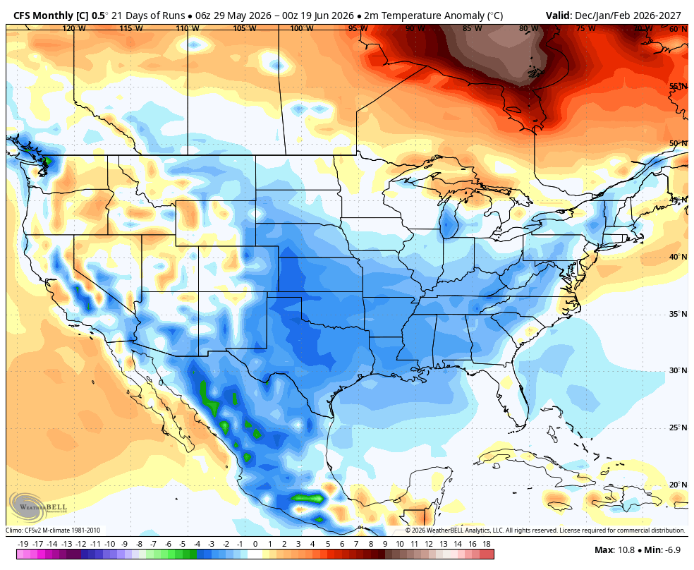
2026-2027 Super El Nino
snowman19 replied to Stormchaserchuck1's topic in Weather Forecasting and Discussion
Yep. The CFS has started to increase again. With the ongoing surface and subsurface warming, another round of strong WWBs coming up late month, another anticipated -SOI plunge next week and very likely another DWKW forming, the July model forecasts will almost certainly bump up -

Central PA Summer 2026 Discussion/Obs Thread
Superstorm replied to Voyager's topic in Upstate New York/Pennsylvania
Beautiful weather next 10 days . -
Yeah the GFS is suppressing things. Euro looks like a sneaky small stream responder problem event there.
- Today
-
Yup, we suck at rain. I give up, done trying to be positive. Everything sucks.
-

Winter cancelled/uncancelled banter 25/26
gravitylover replied to Rjay's topic in New York City Metro
It's not uncommon anymore for us to have 60° Christmas's so what's wrong with that in July? -
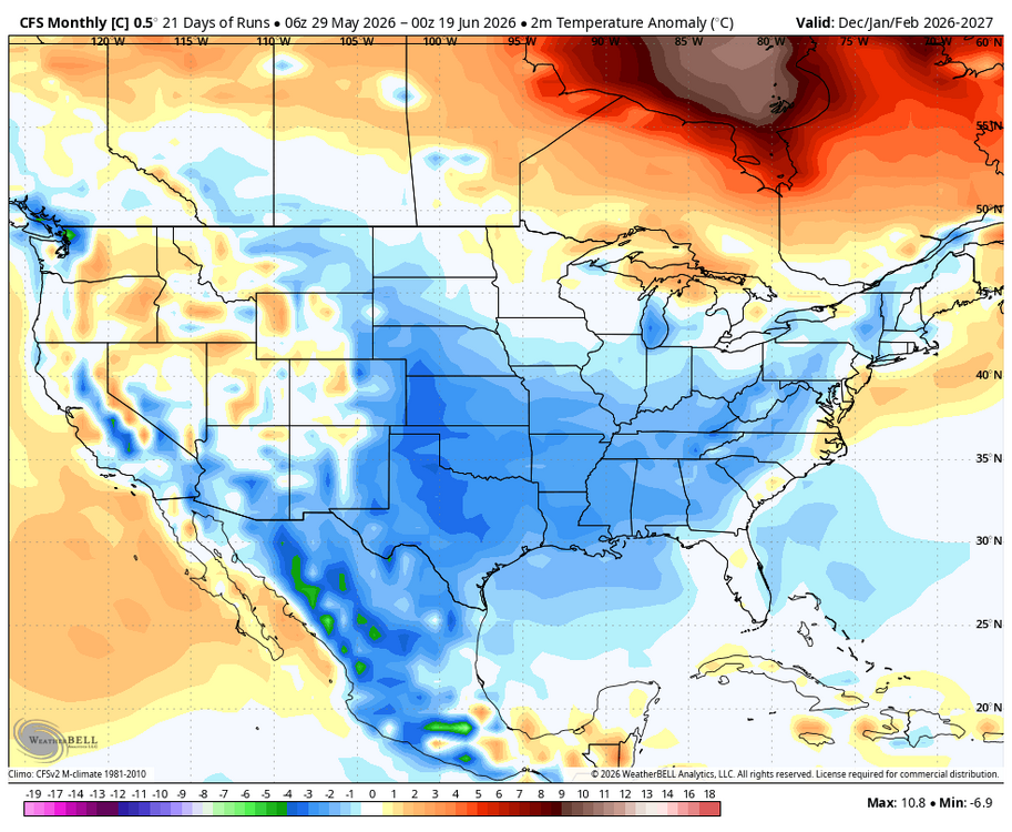
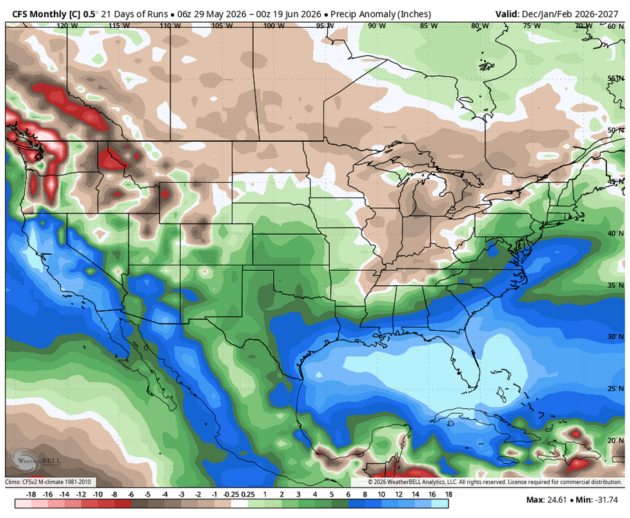
WB last 21 CFS Control runs Dec-Feb.
-
Driest rain I have ever seen.
-
Models with 1 to 1.5" Monday. Fingers crossed