All Activity
- Past hour
-

Augdewst 2026: Summer's Last Stand
Damage In Tolland replied to Prismshine Productions's topic in New England
Just had that showers / boring steady light rain look away from Scoast . -
3-4” for you by the time it’s done. Probably at 3” already.
-

Augdewst 2026: Summer's Last Stand
Lava Rock replied to Prismshine Productions's topic in New England
Getting real tired of getting steined Sent from my SM-S921U using Tapatalk -

E PA/NJ/DE Summer 2026 Obs/Discussion
MGorse replied to PhiEaglesfan712's topic in Philadelphia Region
Yeah that is about where much of the guidance had it, plus it was probably convectively enhanced some. -
December 1986 looks like a pretty good match, too.
-
Enjoy https://www.instagram.com/reel/DcRGIBvuVJ_/?igsi=MXpwNDJyOTdid3c5
-
Little line over my area. Raining fairly hard
-

Augdewst 2026: Summer's Last Stand
WxWatcher007 replied to Prismshine Productions's topic in New England
1.00” of rain at WXW1. Meanwhile it’s 58° and clearing here at WXW2. High of 68.6°. Fall is on the way here. -
Legit tornado in Atlantic beach. Those videos and damage pics make me think strong F1 or perhaps F2.
-

Augdewst 2026: Summer's Last Stand
CoastalWx replied to Prismshine Productions's topic in New England
Man this thing is decaying. Love a good Stein. -
Special Marine Warning ANZ630-650-652-680-682-210200- /O.NEW.KAKQ.MA.W.0197.260821T0036Z-260821T0200Z/ BULLETIN - IMMEDIATE BROADCAST REQUESTED Special Marine Warning National Weather Service Wakefield VA 836 PM EDT Thu Aug 20 2026 The National Weather Service in Wakefield has issued a * Special Marine Warning for... Chesapeake Bay from Smith Point to Windmill Point VA... Coastal waters from Chincoteague to Parramore Island VA out 20 NM... Coastal waters from Fenwick Island DE to Chincoteague VA out 20 NM... Waters from Chincoteague VA to Parramore Island VA from 20 to 60 NM... Waters from Fenwick Island DE to Chintoteague VA from 20 to 60 NM... * Until 1000 PM EDT. * At 835 PM EDT, severe thunderstorms capable of producing wind gusts to 40 knots and waterspouts were located along a line extending from 8 nm northwest of Delaware Lightship Buoy 44009 to 11 nm northwest of Chincoteague Bay, moving southeast at 20 knots. HAZARD...Wind gusts to 40 knots and waterspouts. SOURCE...Radar. IMPACT...Waterspouts can easily overturn boats and create locally hazardous seas. Small craft could be damaged in briefly higher winds and suddenly higher waves. * Locations impacted include... Assawoman Bay, Ocean City Inlet, Chincoteague Bay, Chicken Bone, Parking Lot, Assateague Beach, Blackfish Reef, Gulf Rambler Wreck, Ocean City Pier, 10 Nm East Of Ocean City Inlet, Jackspot Reef, Chincoteague, 10 Nm Se Fenwick Island, Bone Wreck, African Queen Wreck, and Fenwick Island. PRECAUTIONARY/PREPAREDNESS ACTIONS... A Tornado Watch remains in effect until 1000 PM EDT for southeastern Maryland. Move to safe harbor until hazardous weather passes. && LAT...LON 3846 7504 3818 7418 3751 7516 3782 7558 3788 7557 3789 7561 3784 7562 3795 7577 3801 7570 3796 7559 3790 7560 3793 7551 3797 7552 3814 7533 3826 7530 3827 7524 3833 7520 3839 7523 3845 7515 TIME...MOT...LOC 0035Z 310DEG 19KT 3854 7486 3811 7553 WATERSPOUT...POSSIBLE HAIL...0.00IN WIND...40KTS $$ BROWN
-
Feels amazing out there. Temperature 59 with a gusty NNE wind. Feels like mid September! Opening the windows tonight! Rainfall for the day: 2.14". August to date: 7.61" Since 7/1: 16.60" Since 6/1: 22.11"
-
.93 Chance of showers this afternoon.
-

Augdewst 2026: Summer's Last Stand
dendrite replied to Prismshine Productions's topic in New England
-
First mid-lat bomb with snow on the GFS
-
3.00" so far. Just relentless torrential rain since it all started at 7pm so averaging around 1.5"/hr for the past 2 hours now. Had a rainfall rate of over 4"/hr at one point.
-

E PA/NJ/DE Summer 2026 Obs/Discussion
Kevin Reilly replied to PhiEaglesfan712's topic in Philadelphia Region
I’m pretty sure the actual low pressure probably like 1010 mb passed right overhead here in central Delaware County looking at the cloud and wind vectors visually. -
Congrats, Frederick.
-

2026 Mid-Atlantic Severe Storm General Discussion
Eskimo Joe replied to Kmlwx's topic in Mid Atlantic
If it's in Lancaster County, then that is near Ephrata, PA and would verify the second tornado warning. Unfortunately that would mean two tornadoes just outside the Tornado Watch box. -
Yea, cpc uses 1000mb surface pressure patterns for its numerical index calc which throws me off at times too because we always look at 500mb height progs. Surface pressure does correlate to 500mb but things get muddy in that dept. Some of which is due to domain space size. I dont worry too much about the numerical index when 500mb looks tasty lol
-
I just hope the PV is on the weaker side during its formation, as it is beginning to develop right about now. Thinking HL blocking will help us this winter.
-
Not a single drop.
-
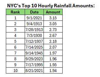
No. It would rank 13th. Below are the ten highest hourly amounts:
-
E PA/NJ/DE Summer 2026 Obs/Discussion
MGorse replied to PhiEaglesfan712's topic in Philadelphia Region
0.65 inches of rain. Had a decent period of wind gusts to around 40 mph at the end of the convection, essentially in the wake of it. Quite the wind shift with that as well and a temperature/dew point drop. -
Nice! That’s south of us right?