All Activity
- Past hour
-

2026 Mid-Atlantic Severe Storm General Discussion
Eskimo Joe replied to Kmlwx's topic in Mid Atlantic
Amazing to watch the soils just absorb the rainfall. -
its what the GFS showed.. but obviously didn't believe it
-
“Hoodies for days”
-
Mesoscale Discussion 1066 NWS Storm Prediction Center Norman OK 0100 PM CDT Wed Jun 10 2026 Areas affected...southern Wisconsin and northern Illinois Concerning...Severe Thunderstorm Watch 301... Valid 101800Z - 102000Z The severe weather threat for Severe Thunderstorm Watch 301 continues. SUMMARY...An arcing line of thunderstorms has organized in eastern Iowa and will move northeastward for the next few hours through WW 301. The threat for severe wind gusts is greatest in the delineated area as the system moves through. DISCUSSION...A line of severe thunderstorms has developed in eastern IA and is moving northeastward into southern WI and northern IL. A 64-kt wind gust was reported at 1740z in Dubuque, IA associated with this convection. Difluence aloft and low-level convergence along the leading edge of a ~10-F-deficit cold pool have likely contributed to storm strengthening during the last hour or so. Per current mesoanalysis, the line of storms is moving into a CAPE axis stretching from central IN northwestward into southeastern MN, featuring 2500+ J/kg along the WI/IL border. Bulk shear magnitudes are around 40 kts and southwesterly, oriented perpendicular to the convective line. This environment will support a threat for continued severe wind gusts as the system moves northeast for the next few hours.
-
Definitely a warm one out there today!
-

2026 Mid-Atlantic Severe Storm General Discussion
wxmeddler replied to Kmlwx's topic in Mid Atlantic
3/4" of Rain in 15 Minutes at the Thurmont MD Mesonet site. -
you must have been drinking a bit to much last night to remember.. but I was saying that I expect 70s and comfortable dews..
-
-
Severe Sunday?
-
Classic humidity today (just got a swampy workout in) and another line moving thru with rumbles in the distance.
-
The 3 km NAM has a 100 kt 500 mb max tomorrow in IA, I cannot recall very many systems at all with that in June @RCNYILWX.
-
Ditty? Is that you?
-
Who looks at the GFS?
-
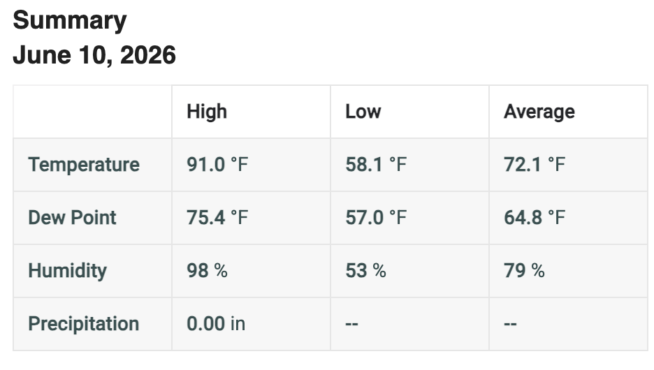
83.6°/70.1° Steamy
-
My friend is at 9.3 mwh for the year and 823 kWh for June. Confirmed via enphase. You made me ask him. He said he’s done decent so far this spring but was less over the winter compared to 24/25. It powers his whole house and that his teslas consume the most…kind of impressive, actually.
-
0.00 this morning ... 0.00 this month ... Central valley is being bypassed with the gap at the moment... Nice radar returns to our north and south...
-
This week of high heat (DVN, a few days ago, had several days in the 90s, maxing at 96 today) is a bust. Monday-Wednesday we reached 80, 88, 83, with the rest of the week likely not even reaching 80.
-
You have some measurable rainfall this month ? Im sitting on 0.00
-

Central PA Summer 2026 Discussion/Obs Thread
mahantango#1 replied to Voyager's topic in Upstate New York/Pennsylvania
76 dp here. -
The NWS is already putting out a few considerable severe thunderstorm warnings in Iowa/Illinois for 70mph wind gusts
-
Parameter space near/south of that warm front in the backed surface winds tomorrow is alarming for any semi-discrete storms that can maintain themselves in the area. While there certainly are some caveats such as storm mode, degree of HP dominance given less than ideal venting flow and high PWATs, and prior convection, the high population and potential for relatively fast moving storms makes this likely the most dangerous setup so far this year on paper.
-
The SPC has all of western MI under the gun tomorrow evening, but the CAMs are split on how much late night crapvection interferes with returning instability. None of the CAMs are exact on convective placement now so it’s up in the air. Hope I at least get a nice storm this evening if tomorrow turns out to be miss south stank.
-
Thank the lord you're still alive. Great to see you here. Thanks for letting us know about the new site. Good luck with it.
-
Sad but true
-
we'll try again tomorrow...


.thumb.gif.f92b16c631a1d15d405ed77b33f0710d.gif)


