All Activity
- Today
-
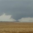
Having reviewed 00z guidance, it certainly looks interesting near western Oklahoma early Sunday evening. Models show troughing across the High Plains with subtle lee cyclogenesis over southwestern Kansas. A belt of enhanced upper level flow should reside from New Mexico across the OK/TX panhandles and into Kansas as the mid level wave ejects. Convective initiation seems likely by mid afternoon near an effective triple point over SW Kansas and with warm advection farther north in central/northern Kansas near a pseudo warmth front. Capping and initially larger T/Td dew point spreads along the dryline over the eastern Texas panhandle will delay convective initiation until late afternoon. With that said, most 00z CAMs show at least one or two isolated storms going up ahead of the dryline by 22-00z. If sustained convection is realized, any storm would move eastward, into western Oklahoma, where increasingly richer moisture will reside. This along with an increasing low level jet would conditionally favor intense supercell development and an associated tornado threat. Given that messy storm modes are more likely across Kansas, the southern target certainly has my attention. Especially given a southern stream perturbation pointing right at the dryline, just south of the surface low.
-
Looks like west and north of Boone are getting hammered.
-
Yeah I'll take the few showers we had today over what I've had to deal with the past few weeks.
-
2024 Short/Medium Range Severe Weather Discussion
Radtechwxman replied to Chicago Storm's topic in Lakes/Ohio Valley
I do agree it is a very impressive shortwave and definitely bares some resemblance to 4-26-24. However, what are your thoughts on shear vector orientation to initiating boundary? Seemed like there was a less than 45 degree component esp to west but more orthogonal to the east. If you get a prefrontal trough could be a bigger tornado threat but wondering if storms fire off DL/pacific front if they will be more of a mixed mode of lines and embedded sups. -
Severe Storm hit at my home this afternoon producing dime size Hail and flooding. I measured 4.33" of Rainfall from the storm. 4.04" fell in an hour and 15 minutes . Numerous driveways washed out , mudslides aling with fallen Tree's. Some strong winds as well with downed limbs.
-

2024 Short/Medium Range Severe Weather Discussion
andyhb replied to Chicago Storm's topic in Lakes/Ohio Valley
Tuesday has big league severe possibilities in Iowa and surrounding area. Don't see many shortwaves with 500 mb flow approaching 90 kts (and relatively low amplitude) and 850 mb flow of 50+ kts this time of year. Has outbreak potential, especially if the trough slows a bit and we get a solution that resembles the last few runs of the ECMWF. -

May 2024 Discussion - Welcome to Severe Season!!!!
Ginx snewx replied to weatherwiz's topic in New England
. 15 here dry night for a mega firepit -

Pittsburgh/Western PA Spring 2024
TheClimateChanger replied to Ahoff's topic in Upstate New York/Pennsylvania
Well we managed three below normal days (officially). I don’t really see many opportunities for below normal temps over the next 7-10 days. Looks well above normal through Wednesday, and then cooler but likely still above normal late next week into the start of the holiday weekend. -
Right. These dudes are all trolls.80/70 does not feel good no matter how you spin it
-
It is not cold...at all haha
-

E PA/NJ/DE Spring 2024 OBS/Discussion
RedSky replied to Hurricane Agnes's topic in Philadelphia Region
First PC was a Coleco -

May 2024 Discussion - Welcome to Severe Season!!!!
mreaves replied to weatherwiz's topic in New England
West was best. I needed to go to Home Depot and also wanted to take a bike ride. Looked at the radar and headed to the Burlington waterfront. Sunny and 75°

-
We had pea sized hail and 40-45 mph winds too. It just kept redeveloping right over top of us.. and of course we are getting another moderate shower now to add to the daily total
-

E PA/NJ/DE Spring 2024 OBS/Discussion
KamuSnow replied to Hurricane Agnes's topic in Philadelphia Region
My 1st PC was a 486-33 (4 on the floor), with (countem) 8 mb of ram. -

May 2024 Discussion - Welcome to Severe Season!!!!
CoastalWx replied to weatherwiz's topic in New England
This event is one of the most woefully modeled events I’ve seen in quite some time. -
Records: Highs: EWR: 94 (2017) NYC: 92 (2017) LGA: 97 (2017) JFK: 88 (1977) Lows: EWR: 43 (2003) NYC: 41 (1973) LGA: 44 (2002) JFK: 42 (2023) Historical: 1825 - A tornado (said to have crossed all of the state of Ohio) smashed into the log cabin settlement of Burlington, northeast of Columbus. (David Ludlum) 1883: The massive tornado outbreak on record in Illinois affected the northern and central parts of the state. At least 14 strong to violent tornadoes touched down killing 52 people. The largest death toll from a single tornado was 12, with 50 injuries, from an estimated F4 tornado which moved from near Jacksonville to 5 miles west of Petersburg. This tornado destroyed the town of Literberry. Another tornado, with an estimated F4 intensity, killed 11 people and injured 50 along its path from the south edge of Springfield northeast to near Kenney. This particular tornado reportedly drove 10 inches by 12-inch oak timbers 10 feet into the ground. Another estimated F4 tornado in far northern Illinois touched down near Capron and tracked for 17 miles before lifting in far southern Wisconsin. Lastly, an estimated F4 tornado tracked 20 miles through Kenosha and Racine Counties in Wisconsin. Eight people were killed, and 85 were injured. 1960 - Salt Lake City UT received an inch of snow. It marked their latest measurable snowfall of record. (The Weather Channel) 1980 - Mount Saint Helens (in Washington State) erupted spewing ash and smoke sixty-three thousand feet into the air. Heavy ash covered the ground to the immediate northwest, and small particles were carried to the Atlantic coast. (David Ludlum) 1987 - Thunderstorms in Kansas, developing along a cold front, spawned tornadoes at Emporia and Toledo, produced wind gusts to 65 mph at Fort Scott, and produced golf ball size hail in the Kansas City area. Unseasonably hot weather prevailed ahead of the cold front. Pomona NJ reported a record high of 93 degrees, and Altus, OK, hit 100 degrees. (The National Weather Summary) (Storm Data) 1988 - Low pressure anchored over eastern Virginia kept showers and thunderstorms over the Middle Atlantic Coast Region. Flash flooding was reported in Pennsylvania. Up to five inches of rain drenched Franklin County PA in 24 hours. (The National Weather Summary) 1989 - Thunderstorms developing ahead of a cold front produced severe weather from the Central Gulf Coast States to the Lower Missouri Valley during the day and evening. Thunderstorms spawned sixteen tornadoes, and there were 74 reports of large hail and damaging winds. (The National Weather Summary) (Storm Data) 1990 - Thunderstorms produced severe weather in the central U.S. spawning a sixteen tornadoes, including a dozen in Nebraska. Thunderstorms also produced hail four inches in diameter at Perryton TX, wind gusts to 84 mph at Ellis KS, and high winds which caused nearly two million dollars damage at Sutherland NE. Thunderstorms deluged Sioux City IA with up to eight inches of rain, resulting in a record flood crest on Perry Creek and at least 4.5 million dollars damage. (The National Weather Summary) (Storm Data)
-
Some nasty heat in FL last few days. Interesting HI stat from Miami. All very recent perhaps reflecting the increased moisture in the atmosphere of late. Don't know now anyone could tolerate FL in the Summer. Just not for me. High sun angle, high temperatures and stifling humidity

-

Central Pa. Spring 2024
Mount Joy Snowman replied to mahantango#1's topic in Upstate New York/Pennsylvania
On the train on the way back from Philly. What a win! #MildlyDrunk -

May 2024 Discussion - Welcome to Severe Season!!!!
Snowedin replied to weatherwiz's topic in New England
Ok, the rain can stop now.. -
0.32" today and 2.43" for the month. Coolish more than warm and humid. Good balance of cloudy days and sun. I'll take this any day for May. Goldilocks.
-
Adding on to the great weather recently trend, enjoyed a beautiful day at Wrigley today watching Cubs pull out a win at the very end
-
May 2024 Discussion - Welcome to Severe Season!!!!
CoastalWx replied to weatherwiz's topic in New England
Been pouring now. Near an inch to my east. At least it waited until night. -

May 2024 Discussion - Welcome to Severe Season!!!!
Typhoon Tip replied to weatherwiz's topic in New England
Not sure. I suspect we all dawn packed in but it will be diurnal inversion cap stratus. The east wind direction will have a modest downslope aspect which then working with the intense solar max insolation we may see breaks opening up first west but then working E -

May 2024 Discussion - Welcome to Severe Season!!!!
kdxken replied to weatherwiz's topic in New England
Semt your post along to HR and security. -

May 2024 Discussion - Welcome to Severe Season!!!!
DavisStraight replied to weatherwiz's topic in New England
You having Maine lobster tonight? I still love me a Maine lobster.