All Activity
- Past hour
-

1/24-1/25 Major Winter Storm - S. IL, IN, MI and OH
ILSNOW replied to A-L-E-K's topic in Lakes/Ohio Valley
snippets from Chicago NWS Forecast attention this weekend focuses on the major winter storm expected to have significant impacts across a good chunk of the southern and eastern CONUS. Locally, our area is expected to remain along the northern periphery of this large and expansive storm system, which naturally adds question marks with regards to how far northwest impactful wintery precipitation will fall. This is especially the case considering that a sharp north- northwestern cutoff in precipitation could occur over, or near parts of northwestern IL. Nevertheless, forecast confidence continues to increase in accumulating snowfall falling across much of central into northeastern IL and northwestern IN, most notably during the Saturday night and on Sunday timeframe. While a majority of the heavy precipitation with this system is expected to fall south of our area, as mentioned, chances continue to increase that much of our local area will experience some accumulating snowfall late Saturday through Sunday. The snow may come in two separate waves, with the first potentially coming Saturday afternoon into the evening, and a second coming Saturday night and on Sunday. Interestingly, with the Arctic airmass remaining in place across our area, the thermodyamics profile in which this snow will be generated within will feature a very deep Dendritic Growth Zone (DGZ), likely in excess of 10,000 ft. This will in turn foster a higher than average liquid-to- snow ratio than is typical for our area, with 20-25+ to 1 ratios certainly in play. Accordingly, even a tenth to two tenths of an inch of QPF that falls could result in a few inches of dry fluffy accumulation. While confidence does continue to increase in at least parts of our local area experiencing some accumulating snowfall Saturday afternoon into Sunday, uncertainty remains with the specifics. For example, as noted above, one of the main question marks that remains is how far northwest into our area accumulating snow will extend. This as the precipitation looks to fight with drier air trying to advect into the region from the Arctic high to our northwest. The other question resides around the extent of lake enhanced snowfall along the south-southwesterly periphery of Lake Michigan Saturday night into Sunday. Low-level thermodynamic conditions do look favorable for this, and there is concern that this could result in higher snow amounts along and near the lakeshore into Sunday. Stay tuned for forecast updates! -
I was taken away from my set by responsibilities. I am kinda glad I didn’t keep calling that weird ass run
-
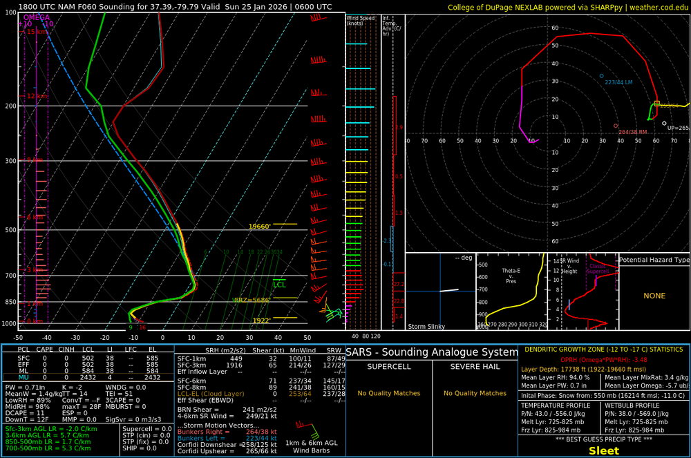
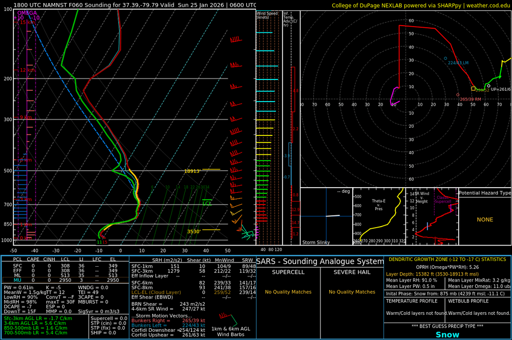
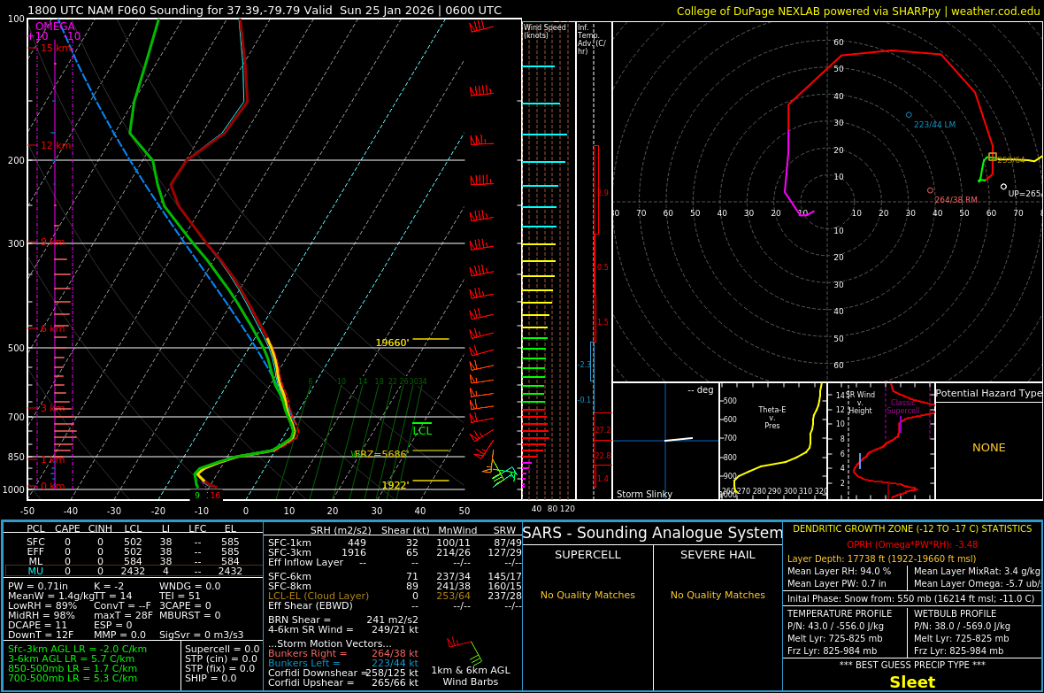
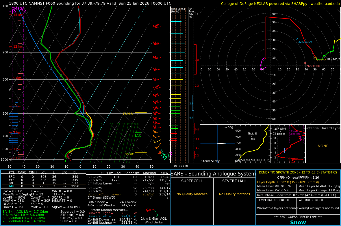
Picked a spot in SW VA where the parent NAM had sleet and 3km NAM had snow for the same time. A couple of degrees difference.
-
Yea but in this case what it did made sense...weaker wave initially, WAA runs out ahead of the main support, weaker...less Thump...GFS kind of has this...but its offset by a south enough second wave that we just snow for 24 hours... NAM we get the weaker initial thump but then flip anyways. That is the in between screw solution. And its not impossible...not likely...not with only the NAM showing it. But I've seen this kind of thing before...remmeber yesterday when I said "the only way MD doens't get a warning level event is if this splits and the WAA wave runs out ahead and then the second wave cuts...this was that disaster scenario I had made up in my head.
-

1/24-1/25 Major Winter Storm - S. IL, IN, MI and OH
Cary67 replied to A-L-E-K's topic in Lakes/Ohio Valley
One last jolt from the paddles before last rites read -
Unfortunately, it looks like it might be headed that way. Ugh.
-

Pittsburgh/Western PA WINTER ‘25/‘26
Rd9108 replied to Burghblizz's topic in Upstate New York/Pennsylvania
-

1/23/26-1/25/26 Winter Storm Thread
Holston_River_Rambler replied to AMZ8990's topic in Tennessee Valley
Can't argue with that. Maybe there will be the illusive Bays Mt lake valley CAD? -
 its 6-12 on the map for most of nj...on kuchera its 7-13
 -
Still not him, not yet.
-
 by the time the dry slot happens it would be a mix anyway and theres around a foot on the ground in NYC.
 -

MO/KS/AR/OK 2025-2026 Winter Discussion
StormChazer replied to stormdragonwx's topic in Central/Western States
I just truly don't see that verifying, I think the NAM has a warm bias and the sleet stays 1 or 2 counties south of Tulsa. THe high resolution actually keeps the sleet south(2nd wave yet to occur on this run). -
-150 odds that it does this. .
-

1/24-1/25 Major Winter Storm - S. IL, IN, MI and OH
A-L-E-K replied to A-L-E-K's topic in Lakes/Ohio Valley
U will know it's real when moneyman starts posting -

January 25/26 Jimbo Back Surgery Storm
NorthHillsWx replied to Jimbo!'s topic in Southeastern States
Good vibes for happy hour. It’s long range NAM but we want it rebuking the EURO at mid levels and showing sleet. Which it did, bless its heart Track and precip fits the go home you’re drunk narrative -
NAM gets DC awfully close to Uccellini's call of being better off in Chicago. Yesterday we said he was nuts- who is laughing now.
-

“Cory’s in LA! Let’s MECS!” Jan. 24-26 Disco
moneypitmike replied to TheSnowman's topic in New England
Based on that picture, .looks like a big suck for maine -
Very, very curious to see the GFS and Ukie’s next run.
-
Here in Burlington too. IMG_7191.mov
-

Pittsburgh/Western PA WINTER ‘25/‘26
RitualOfTheTrout replied to Burghblizz's topic in Upstate New York/Pennsylvania
How many times has the NAM at range worked out when we needed what it showed? The 3K is good for short range, but there is a reason this thing is getting retired. Not that it't can't be onto something, but I wouldn't let it ruin your day. Let the GFS and Euro do that. -

Possible Record Breaking Cold + Snow Sunday 1/25 - Tuesday 1/27
MJO812 replied to TriPol's topic in New York City Metro
Agree -
Seems like the nam has them too. Maybe just downslopjng the warm areas?
-
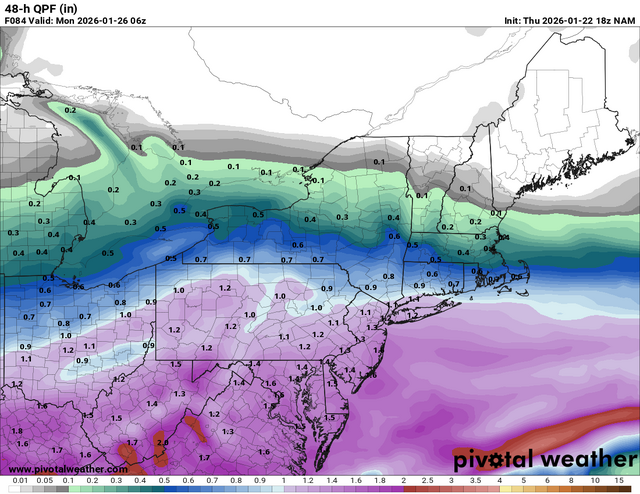
NAM (sigh, why are we doing this to ourselves) trend with QPF is slower/lower today. And maybe a hair dryer, but that may just be because of the slower? This is only through 18z sunday, as far as can be compared over past 12 hours
.thumb.gif.28d90c80a713811974702c8397ed7adc.gif)
-
Mountain wave coming from the southeast. The second to last green streak is likely Camp Creek. The other one is Unicoi.
-

Possible Record Breaking Cold + Snow Sunday 1/25 - Tuesday 1/27
eduggs replied to TriPol's topic in New York City Metro
Yup, cooled a touch across our area. Pretty solid CNJ north with sleet and dryslot at the end. Very curious if there would be any snow on Monday from that trof back to the west.


.gif.7035414e4477ca78d6476391c7175505.gif)
