All Activity
- Past hour
-
Yes. That kind of historic rainfall is very likely overdone. Not surprisingly, the 0z corrected toward lower amounts.
-
NoVA lost 200” of snow at 0z. Poor @Ji
-

Central PA Fall Discussions and Obs
mahantango#1 replied to ChescoWx's topic in Upstate New York/Pennsylvania
-
It’s starting to look like the MJO wave isn’t going to make it past phase 6/7 (MC) before it hits strong subsidence, dies and ends up back in the IO again. That will likely result in yet another big drop in an already persistently negative AAM. As much as some things match up, at least as far as the AAM goes, this fall has been world’s apart from last year….
-
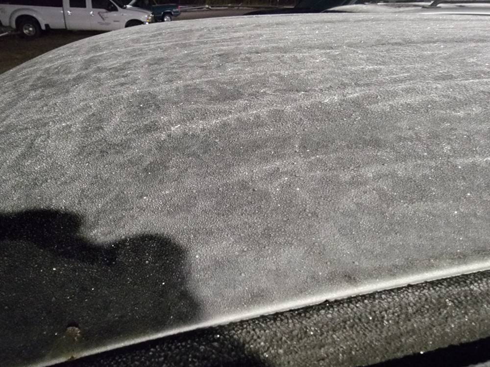
Frosty morning in West Asheville with a temp of 36. Sent from my SM-G998U using Tapatalk
- Today
-

2025-2026 ENSO
Stormchaserchuck1 replied to 40/70 Benchmark's topic in Weather Forecasting and Discussion
It's still at $3.40, which is lower than average. I like to use $5 as a gauge for expected Winter NAO state.. under $5, more +NAO, over $5 more -NAO. It was $2.99 on Friday and has risen a lot in the last 2 days.. +12% it looks like, but the market is volatile and long range models have been showing cold for a while to start November.. so it might be more about Winter expectations, but the price is not currently high... -

Spooky Season (October Disco Thread)
ineedsnow replied to Prismshine Productions's topic in New England
also pretty cold on the CMC -

E PA/NJ/DE Autumn 2025 Obs/Discussion
LVblizzard replied to PhiEaglesfan712's topic in Philadelphia Region
Check out the end of the 0z Canadian. It has the ultra rare hurricane phasing into a cold airmass so much of the interior Northeast gets a very white, windy Halloween. Probably won’t happen but it’s fun to look at. -

Mid to long range discussion- 2025
WinstonSalemArlington replied to wncsnow's topic in Southeastern States
-
Spooky Season (October Disco Thread)
ineedsnow replied to Prismshine Productions's topic in New England
0z Canadian is a hit -

Spooky Season (October Disco Thread)
Snowedin replied to Prismshine Productions's topic in New England
I know a Melissa or two in the past I wouldn’t mind having flung back at me! -
Outside the mountains snow showers showing up in fantasy land on the GFS. Obviously likely to be gone next run, but definitely a sign several runs in a row of very cold air for the time of year, entering the East for November. Never a sure thing, but as I've found and said before, cold Novembers often lead to memorable winter weather events in the following winter. It's a better than 60 percent of the time that it happens, so a decent statistical increase.
-
0Z runs: all are now out -Icon cat 2 H W. Haiti -CMC first moves W and then WNW/NW to Jamaica as a TS followed by SW and then abrupt turn to N and then NNE/NE over C Cuba/NC Bahamas as a cat 3 H followed by a turn back to the N with it ending on a heading toward Cape Cod as it gets caught on the E side of a strong trough/upper low -GFS very consistently hits Hispaniola again (cat 2 H) -Euro just W of Jamaica, EC Cuba to C Bahamas (MH) -UKMET remains quite consistent with the track and this time the text has it as a TC through hour 156, after which it weakens on approach to the NE Nicaraguan coast. The direction of movement starts off mainly WNW (with the furthest N being at 15.3N, which is actually furthest N of recent runs) followed by W and then WSW; strongest it gets is a minimal TS and lowest SLP 1004. At hour 156, the 0Z UKMET is a whopping 1,500 miles WSW of the 0Z GFS! TROPICAL STORM 98L ANALYSED POSITION : 11.1N 69.0W ATCF IDENTIFIER : AL982025 LEAD CENTRAL MAXIMUM WIND VERIFYING TIME TIME POSITION PRESSURE (MB) SPEED (KNOTS) -------------- ---- -------- ------------- ------------- 0000UTC 21.10.2025 0 11.1N 69.0W 1009 30 1200UTC 21.10.2025 12 14.0N 71.5W 1008 35 0000UTC 22.10.2025 24 14.0N 73.6W 1006 31 1200UTC 22.10.2025 36 14.2N 74.3W 1005 34 0000UTC 23.10.2025 48 15.3N 75.2W 1004 31 1200UTC 23.10.2025 60 15.3N 75.8W 1005 33 0000UTC 24.10.2025 72 15.3N 76.8W 1005 28 1200UTC 24.10.2025 84 15.3N 77.3W 1005 27 0000UTC 25.10.2025 96 14.7N 78.0W 1005 25 1200UTC 25.10.2025 108 14.6N 79.1W 1006 26 0000UTC 26.10.2025 120 14.2N 80.6W 1004 23 1200UTC 26.10.2025 132 14.4N 81.8W 1005 25 0000UTC 27.10.2025 144 13.9N 82.5W 1004 20 1200UTC 27.10.2025 156 14.1N 82.8W 1005 18 0000UTC 28.10.2025 168 CEASED TRACKING
-
Who thinks these amounts are too high in PA down through VA ?
-

Monday, October 20, 2025 Squall Line Potential
dendrite replied to weatherwiz's topic in New England
1.34” Need all of it. Well has been going dry after a couple showers… -

Spooky Season (October Disco Thread)
tunafish replied to Prismshine Productions's topic in New England
Easy to see how - as others have said - Freshwater flooding is going to be the most impactful (costliest, deadliest) weather event related aspect of AGW. Probably already is. -
Spooky Season (October Disco Thread)
tunafish replied to Prismshine Productions's topic in New England
I have to imagine there's some water level rising in the area PF described. Impressive if not. -
Absolutely stunning Fall day today. Colors, blue sky, crisp air. Perfect October weather.


-

Monday, October 20, 2025 Squall Line Potential
rimetree replied to weatherwiz's topic in New England
.64 here...can we cancel the burn ban now? -

Monday, October 20, 2025 Squall Line Potential
powderfreak replied to weatherwiz's topic in New England
Western slope communities getting crushed.
-
There has been plenty of talk about the upgrade to EF-5 in Enderlin, North Dakota. (You may want to check out multiple videos on Youtube.) Here was, I believe, the closest time frame that I saved of that tornado (June 20th, 11:08PM central)
-
High of 73 . Low is our current temp of 50. Dew points stayed in the low 40's. Felt really nice outside.
-

2025-2026 ENSO
40/70 Benchmark replied to 40/70 Benchmark's topic in Weather Forecasting and Discussion
I'm sure snowman will be embedding a tweet to this effect in the AM. scoop -
1.10” wind max at home 18 mph. Meh
-
NG was way up at 3.55 on Oct 7th. It then plunged to the Oct 17th low of 2.89, a drop of 19%, on continued mild temperatures in the E US throughout the 2 week forecast period. This drop was caused by speculators selling to go flat or, in some cases, short. Then suddenly over this past weekend, when markets were closed, the models started cooling their late week 2 forecasts to near normal. Even though that’s not due to Canadian air, it’s still notably colder than the 2 weeks of mild that had been dialed in by the market on Friday. Thus as of Fri, the majority of spec traders had been short. Then this change to a less mild period late in week 2 meant a forecast of higher HDDs, which means newly progged higher NG usage than earlier progged. When the market opened last evening, there was a sharp gap up due to so many shorts running for the exits by buying to go flat. In addition, some of these specs decided to buy additional contracts to go long. In summary, the sharp price rise was due to a sharp increase in forecasted HDDs during the 2 week period rather than a forecast of very cold. Large changes in 2 week forecasts cause the largest price changes. Had the forecasts last week already had near normal in late week 2, prices on Friday would have been higher than they actually were and thus there wouldn’t have been today’s big rise.


