All Activity
- Past hour
-
Our daughter is supposed to be tentatively camping in the White Mountains this weekend. Might be a good idea to cancel.
-
2.09 here.
-
2024-2025 La Nina
PhiEaglesfan712 replied to George001's topic in Weather Forecasting and Discussion
1988 was actually one of the warmest summers on record at that point. Coincidentally, October 1988 was one of the coldest on record. If the 32 low in July is true, I'd be willing to bet they got a sub-zero low during that October. - Today
-
Fusion could easily solve the climate crisis, the giant fusion reactor in the sky. Human power is roughly 1/100,000 of the energy available from the sun. Unfortunately China is getting close to the solar and battery finish line and we're not aware of the race.
-
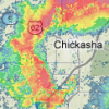
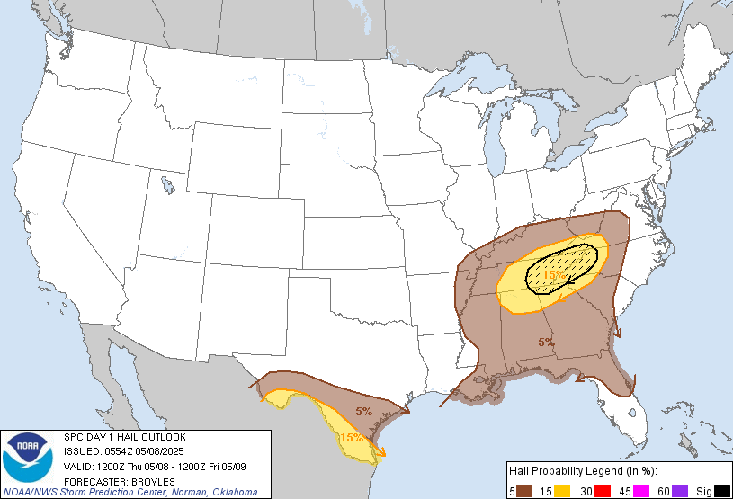
Day 1 SPC: ...Southern Appalachians/Tennessee Valley/Southeast... A positively-tilted mid-level trough, and an associated cold front, will move through the Ohio and mid Mississippi Valleys today. Surface dewpoints to the south of the front will range from the mid 50s to the mid 60s F. As surface temperatures warm during the day, moderate instability is expected to develop across much of the moist airmass. A cluster of organized thunderstorms is forecast to develop in the afternoon from western and central Kentucky into middle Tennessee, and eastward into the southern Appalachians. This large cluster will move southeastward into northern Alabama, northern Georgia and the western Carolinas by late afternoon. RAP forecast soundings along the zone of maximum instability have 0-6 km shear in the 35 to 45 knot range, with 850 to 500 mb lapse rates near 7 C/km. This environment will support the development of supercells with large hail, in areas where the storms can remain semi-discrete. Hailstones greater than 2 inches in diameter will be possible with the more intense supercells. In addition, forecast soundings show very steep low-level lapse exceeding 8 C/km, which will be supportive of damaging wind gusts.
-
More skeptical now about 90 degree weather for NYC during the month of May than I was a week ago. The pattern seems to remain very stormy and over the top with the heat with an active storm track now out of the Gulf of Mexico and across the southeastern states tending to back up along the east coast and often times hooking back inland at or prior to our latitude. This is a pattern which can produce way above normal rainfall in the east for our region and points south especially. There is an outside chance that we find enough sunshine on a day or two May 14th-21st but I'm doubtful at this time. I think it's going to be extremely active and wet. Some locations well to our northwest even over northwest NY State & parts of Canada may have a better chance at a day or two of the early heat. WX/PT
-
Could see some decent hail with the storms tomorrow in East TN.
-

2025 Lawns & Gardens Thread. Making Lawns Great Again
radarman replied to Damage In Tolland's topic in New England
Keeping an eye on temps saturday night sunday morning. Planted early, but could cover stuff if necessary. Maybe winds and dews will stay up -
Stein pocket. I looked around and a lot are over an inch. You’ll get yours Friday.
-
Not exactly, .74 for the month here
-
Mountain West Discussion
mayjawintastawm replied to mayjawintastawm's topic in Central/Western States
1.01"- can't complain too much. All the showers today missed one direction or the other. -
Ianlian7 joined the community
-
Northern regions likely won’t share in this sentiment but today turned decent down here. Most will share in a decent day tomorrow though. If rains two days later meh. Normal. It’s not a bad thing to sack Friday if it means continued stuffing of that word up the butts of those who obsess over typing it … In more practical matters, we need more rain
-
Had 3 drops of rain here. Hit 84 for the high.
-
72 full sun and a slight breeze today. Some precipitation showing up in fantasy range.
-
1.83" I take back my bust comment.
-
The GFS and the CAMs were right about the band of thunderstorms through central Iowa late this afternoon. I picked up 0.35" of rain, with plenty of rumbles and a bit of small hail.
-
At this point in my locale, I don't need any more rain for a week or two. The winter springs are open at my place. I mowed with water coming out of the ground today.
-
I know 3 good ones at Penn state medical. They have offices in hershey and Middletown. I can private message you if you like. Hang in there. It does get better. Sent from my SM-X210 using Tapatalk
-
I think with that reservoir capacity question, 100% is an optimal design level, 110% is probably a few feet above 100% and barely noticeable to a casual observer, but an overflow situation is likely to be 135% or even 150% of capacity, there's a margin for surplus capacity and managers will tolerate it especially if they foresee lower levels in the near future. Depends on local terrain and size of dam holding the reservoir in place.
-
They’re always low. Most places 1-2 here.
-

Central PA Spring 2025
Itstrainingtime replied to canderson's topic in Upstate New York/Pennsylvania
Thank you very much for that. I'll keep everyone posted. -
Tomorrow will be partly sunny and warm. Temperatures will likely rise into the lower and middle 70s. Another system could affect the region Friday into Saturday before a cooler drier air mass arrives. Showers and perhaps some heavy thunderstorms are possible. A general 0.50"-1.50" rainfall is likely with some locally higher amounts. Following the weekend, it will turn warmer and possibly drier. The ENSO Region 1+2 anomaly was +0.1°C and the Region 3.4 anomaly was -0.1°C for the week centered around April 30. For the past six weeks, the ENSO Region 1+2 anomaly has averaged +0.68°C and the ENSO Region 3.4 anomaly has averaged -0.05°C. Neutral ENSO conditions will likely continue through at least early summer. Early indications are that summer 2025 will be warmer than normal in the New York City and Philadelphia areas. The potential exists for a much warmer than normal summer (more than 1° above normal). The SOI was +5.23 today. The preliminary Arctic Oscillation (AO) was +1.550 today. Based on sensitivity analysis applied to the latest guidance, there is an implied near 75% probability that New York City will have a warmer than normal May (1991-2020 normal). May will likely finish with a mean temperature near 66.0° (2.8° above normal). That would tie 1986 for the 9th warmest May on record.
-
74 today
-
ya eastern areas meh.. they will get more at the end of the week though..
-
BOS at .43" going into today.


_X.thumb.png.47ca5c2e0afbbf336f75bcc5966fc69d.png)


