

Runman292
-
Posts
766 -
Joined
-
Last visited


-
Jeff, I have a question out of curiosity. It may just be me, but it seems like almost all severe weather threats in East TN take place in the late evening/overnight hours. Afternoon severe weather events appear to be somewhat rare. Is there any truth to this, and what causes this?
-
It is a rare occurrence to see a severe hail only event in East TN.
-
Think oak ridge had a very light dusting, then it melted in just 10 minutes once the snow stopped. Wasn't expecting anything, so not really disappointed. Quiet winter for sure snow wise here.
- 289 replies
-
- 3
-

-
- severe
- mountain snow
- (and 1 more)
-
Considering the timing, the wind threat must be pretty substantial to extend the enhanced risk into the western part of East TN.
-
Crazy to see the hatched area include most of the marginal risk areas as well.
-
MRX still has the 1-33 inch forecast on the WWA for Anderson and surrounding counties, so maybe I'm in a good spot in Oliver Springs, lol.
- 782 replies
-
- 3
-

-
-
- extreme cold
- snow
- (and 1 more)
-
Figures that the western valley counties like Anderson wouldn't be in it. I'd love 1 good snow before spring. Hope there's still some room for a shift.
- 782 replies
-
- 3
-
-
- extreme cold
- snow
- (and 1 more)
-
Light to moderate snow in Oliver Springs. I'm staying at a friend's house for a few days. The road at my house in Oak Ridge is already iced over.
- 618 replies
-
- 1
-
-
- observations
- obs thread
- (and 1 more)
-
I have returned from the dead, lol. What have I missed? Ice storm is definitely not what I'm wanting to see. I'm hoping that my neck of the woods in Oak Ridge isn't hit too hard.
-
1st Day 1 Outlook has the 10% Tornado area as far east as Knoxville.
-
Day 1 SPC: ...Southern Appalachians/Tennessee Valley/Southeast... A positively-tilted mid-level trough, and an associated cold front, will move through the Ohio and mid Mississippi Valleys today. Surface dewpoints to the south of the front will range from the mid 50s to the mid 60s F. As surface temperatures warm during the day, moderate instability is expected to develop across much of the moist airmass. A cluster of organized thunderstorms is forecast to develop in the afternoon from western and central Kentucky into middle Tennessee, and eastward into the southern Appalachians. This large cluster will move southeastward into northern Alabama, northern Georgia and the western Carolinas by late afternoon. RAP forecast soundings along the zone of maximum instability have 0-6 km shear in the 35 to 45 knot range, with 850 to 500 mb lapse rates near 7 C/km. This environment will support the development of supercells with large hail, in areas where the storms can remain semi-discrete. Hailstones greater than 2 inches in diameter will be possible with the more intense supercells. In addition, forecast soundings show very steep low-level lapse exceeding 8 C/km, which will be supportive of damaging wind gusts.
-
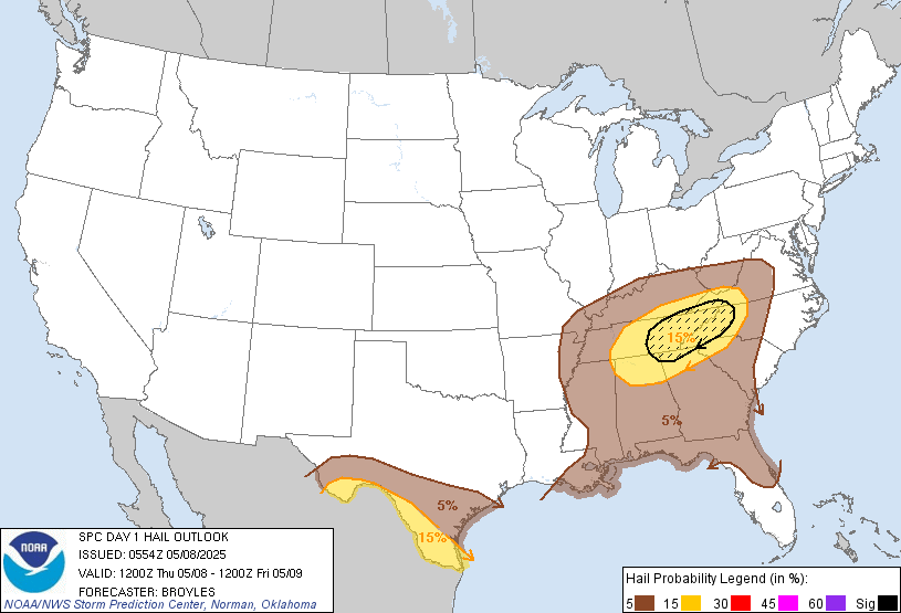
Could see some decent hail with the storms tomorrow in East TN.
-
It is looking like a huge factor as far as the severe threat is concerned for East TN is the timing of the cold front arrival.
-
I'm surprised that there was no tornado reports from the previous storms in Loudon and Anderson counties.
-
That tornado barely missed my house in Oak Ridge. Me and my wife are ok.
- 754 replies
-
- 11
-

