All Activity
- Past hour
-

E PA/NJ/DE Spring 2026 Obs/Discussion
LVblizzard replied to PhiEaglesfan712's topic in Philadelphia Region
Another week of boring ass weather. Yawn…wake me up when we start getting weekly severe thunderstorm chances. -
Makes perfect sense to me.From JB:April 5, 2026The forecast numbers have been taken way down.The Canadian model has been thrown out.The European indicates a powerful El Niño and a negative AMO "look".The closest analog is 2015.The impact forecast is a roll of the dice.Impacts will likely be below normal and scattered.There is always the threat of one (un)lucky punch.Early season Gulf or SE system a concernThe Western Pacific will take up the Global slack.Eastern Pacific Mexican higher impact season possibleThe forecast numbers for the 2026 seasonTotal storms: 9-13Hurricanes: 3-5Major Hurricanes: 1-2Landfalling U.S. hurricanes: 1-2Impact storms on the U.S. when at least a warning is issued: 3ACE Index: 85-105The closest analog is 2015
-
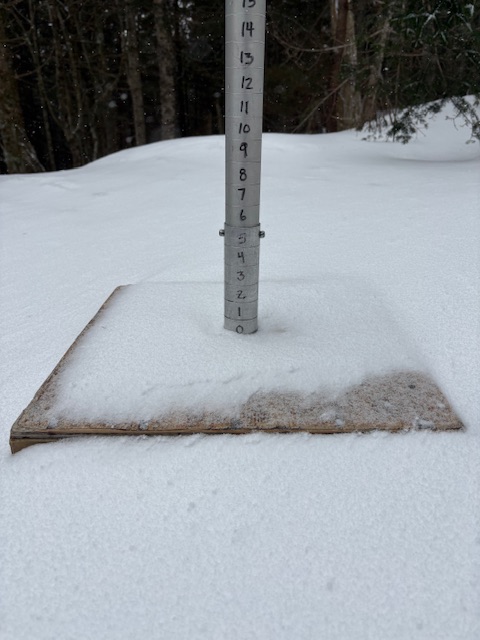
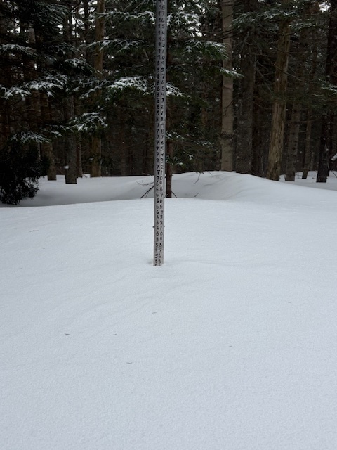
What an icy disaster today. The Lookout Snow Cam had 3” but reality was less. Could've added 3” to the tally but went with 1” instead. High Road had less than 1”, which is what the hill skied with. But there’s no shortage of snow in general.
- Today
-

2026 Atlantic Hurricane Season
Stormchaserchuck1 replied to Stormchaserchuck1's topic in Tropical Headquarters
-

Historic Tennessee Valley Cold, Snow, and Ice Events
Daniel Boone replied to Carvers Gap's topic in Tennessee Valley
That Map is low on Totals in much of the area. The Snow started where I lived west of Pennington gap around 1:15 Thursday the 2nd as a rain/snow mix that quickly turned to all Snow. It continued non stop until 1:15 Sunday the 5th. I measured about 20" at it's deepest but, it was melting underneath the whole time as the ground was warm from 2 Weeks of temps in the 70's before this. There was 30" on a parked Vehicle that sat near the north side of my Neighbor's house at the time the Snow ended. I did have some Photos I'd taken of it but misplaced them in moving process. -
I don’t want this.
-
Absolutely beautiful day here. Pollen and dust was gone, wind died down to just a slight breeze and a high of 69 with the dew point of around 50.
-
We’re due for a derecho, too.
-
Yep El Nino on the way. Strength is yet to be determined.
-

Occasional Thoughts on Climate Change
gallopinggertie replied to donsutherland1's topic in Climate Change
Those past catastrophic events in the geological record didn’t have anywhere near as rapid a rise in CO2 as we are causing now, yet still caused mass extinctions. It’s easy to forget how truly short our lives our - the fact that baby boomers have seen a rise of about 30%, give or take, in CO2 levels over the course of their lifetimes, is crazy. -
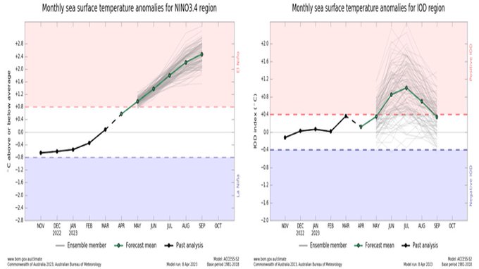
In 2023, the same BoM model also had it getting to +2.4 at the same time (Sept) as per snowman’s post at the bottom of this post. Here was that 4/8/23 run: But “it” back then was ONI, which like now was then ~0.5 higher than RONI. So, it implicitly was predicting RONI only at +1.9. Thus, the current BoM prog on an apples to apples basis is progging 0.5 warmer than what it had 3 years ago. But also keep in mind that the ‘23 BoM turned out to be significantly too warm for the ONI. In Sept, ONI verified to be only +1.64 meaning a large bust of +0.76! RONI was only +1.15. If this BoM run were to bust as badly to the top warm side, the Sept RONI would be at +1.64.
-

Central PA Spring 2026 Discussion/Obs Thread
mahantango#1 replied to Voyager's topic in Upstate New York/Pennsylvania
56 was the high here today. -

Spring 2026 Med/Long Range Discussion
BeastFromTheEast replied to Brian D's topic in Lakes/Ohio Valley
I’m Just hoping the hose doesn’t shut off for June/July/August. A dessert like summer could wipe out all of the drought progress this spring. -
I want to touch the concept of consensus for a moment. Consensus in science works a bit different than what you may be thinking. It's not a majority opinion of people. Instead it is the position most likely to be true based on the aggregation of multiple lines of evidence. An example that might resonate best with the audience here is weather forecasting. Model ensembling (like intensity and track forecasts of tropical cyclones with IVCN and TVCN) incorporate multiple lines of evidence. They are often referred to as consensus forecasts. It has nothing to do with people's opinions or even people at all. And as long as there are 2 or more lines of evidence then a consensus exists. It turns out that consensus forecasts have superior skill vs utilizing only one line of evidence. It doesn't matter if a majority of people accept it or not. In reality you do find that majority opinion tends to rally around the scientific consensus at least eventually. It is important to mention the concept of consilience as well since "consensus" and "consilience" are sometimes used interchangeably though they are subtly different. But that's a topic for another time. My point is that when many of use the word "consensus" to describe our understanding of climate change we aren't necessarily invoking the opinions of people, but instead the consilience of evidence.
-
A super nino here means napril all of next winter here
-
Strongest in a century? We don't have adequate/detailed enough ocean temp records prior to the 1970s to properly quantify the true extent of super El Ninos, which explains why we have only have had 3 since the 1980. https://ggweather.com/enso/oni.htm of 4 if you use RONI: https://ggweather.com/enso/roni.htm Also, any headline that asks a question, the answer is almost always a "NO." It is a devious way to present something as if it will happen when it is not likely to happen or highly uncertain at the time. This is done in wx en masse w/ teasing suppositions and conjectures. And the sub-headline states: "increasingly likely wide-reaching climate impacts that last into 2027." First, it is not climate impacts, it is wx impacts. Atmospheric phenomena impacted from El Nino are short-term. That is wx, not climate. It does not impact "average wx over a long period," it impacts individual wx events/patterns of various degrees in the 1-1.5 year window El Ninos last. This idea that wx=climate and vice versa is ridiculous. Changing the meaning of words to fit a narrative/ideology. Second, why wouldn't El Nino (of any strength, or La Nina for that matter) not have wide-reaching impacts? This is redundant. We know ENSO has wide-reaching impacts, as do the at least a dozen other global and hemispheric oscillations that exists. Third, how can a potential of something be increasingly likely to have impacts? You have something that is uncertain to occur (potential), so how can it be scaled as being increasingly likely to have impacts when you are not even sure if it will occur in the first place? You are putting the wagon in front of the horse here. Not being pedantic here. How science-based information is conveyed is important. Not defining terms correctly or using improper logic/reasoning is bad science.
-
Masters week….my favorite sports week/weekend.
- Yesterday
-
all else being equal, i really missed all this daylight we have now
-
Folks are spooked from this past winter. I've been getting inquiries on large amounts of firewood recently. Way earlier than usual. I guess the commander in Chief may have something to do with it.
-
Cooler conditions have returned to the region. Temperatures will likely top out in the 50s through Thursday. Highs on Tuesday and Wednesday will likely struggle to reach the lower 50s. Wednesday morning could see the low temperature approach 32° in New York City. Should the mercury reach 32°, New York City would see its second consecutive April with a freeze (last year's last freeze was April 9). The last time that happened was 2015 and 2016. Temperatures will return to the 60s on Friday. The warmth will extend into the weekend. The ENSO Region 1+2 anomaly was +1.2°C and the Region 3.4 anomaly was +0.2°C for the week centered around April 1. For the past six weeks, the ENSO Region 1+2 anomaly has averaged +1.25°C and the ENSO Region 3.4 anomaly has averaged 0.00°C. Neutral ENSO conditions will continue through at least mid-spring. The SOI was -7.43 today. The preliminary Arctic Oscillation (AO) was +1.535 today.
-
Please no
-
Could be an interesting night in southern Iowa. Some of the models are suggesting a very narrow swath of 6" or more of snow from a very intense stationary band of snow to develop.
-
Looks like El Nino gonna go boom too. Gonna be a hot summer it looks like... Might have to import water instead of oil... lol?
-

2026-2027 El Nino
roardog replied to Stormchaserchuck1's topic in Weather Forecasting and Discussion
It looks like there’s been lower pressures around Tahiti but it seems we’re missing the high pressure around Darwin which isn’t allowing the SOI to really tank. -
The ensembles continue to show 2.5-3" of rain across the area over the next two weeks. That's great as we head into the warm season, but it's a problem for the construction crew that has to re-grade the new stormwater wetland next to my house and then plant seed.