All Activity
- Past hour
-
Next time let me start the storm thread. Screw back surgery.
-
8-14” 50% 12-18” 25% BOOM 4-8” 25% BUST
-
The 540 line isn't gospel. There is a site for the AIFS that does p-type that I should've bookmarked, but it keeps us snow as that site views it verbatim. If I can find it again I'll mark it.
-
Having a dynamic SLR is great. I find it can still be a little high with cold environments, especially if lacking deep lift. There is also the thing with high ratio snows where compaction begin quite quickly as amounts increase. The resulting 6hr, 12hr, end of storm measurements, etc. can be quite different in these setups.
-

Possible Record Breaking Cold + Snow Sunday 1/25 - Tuesday 1/27
MJO812 replied to TriPol's topic in New York City Metro
I like 12-18 inches right now -
This is why I never get excited before we are 12 hours out, and then it is with measured excitement. At the same time, I don't jump off a cliff until them either if there is any hope.
-

Possible Record Breaking Cold + Snow Sunday 1/25 - Tuesday 1/27
SACRUS replied to TriPol's topic in New York City Metro
-
3 inches of snow to a lot of sleet and freezing rain here in Avery. We unfortunately (in CAD) situations stay very cold. Oftentimes we are 20 degrees colder than Asheville. Changeovers to rain are frequently predicted but rarely come to fruition. We are blocked in by 5-6000 foot peaks on all sides.
-

Possible Record Breaking Cold + Snow Sunday 1/25 - Tuesday 1/27
David-LI replied to TriPol's topic in New York City Metro
what do you mean by making? There are free websites that offer premium services, like pivotalweather, and tropicaltidbits to view weather model maps. Not sure about making one. -
What did PD II give us snow wise before the crust?
-
probably the biggest storm since March 2023 here
-

Possible Record Breaking Cold + Snow Sunday 1/25 - Tuesday 1/27
Jt17 replied to TriPol's topic in New York City Metro
I'm not going to complain. I'm telling you what's going to happen in this forum because it happens every time. . -
.
-
Yall won’t have to hear the whining from us foothills guys anymore! We’ll be in the Stone Age for a while
-
Even if we do get sleet or freezing rain... It is not like it is going anywhere. It will just compact the snow some.
-
it's still uncomfy for you guys, but i still think most of the damage is done before any mixing... nobody should be complaining about 8" of snow in like 4 hours followed by some mix. if the mix does end up occurring at all
-

Richmond Metro/Hampton Roads Area Discussion
RVASnowLover replied to RIC Airport's topic in Mid Atlantic
I'd rather have a plain cold rain than the ice storm Euro is showing. Maybe it's overdone but still -
Euro had me with 15 inches of snow and then went to freezing rain less than 24 hours later. I was more than barely in the snow line.
-
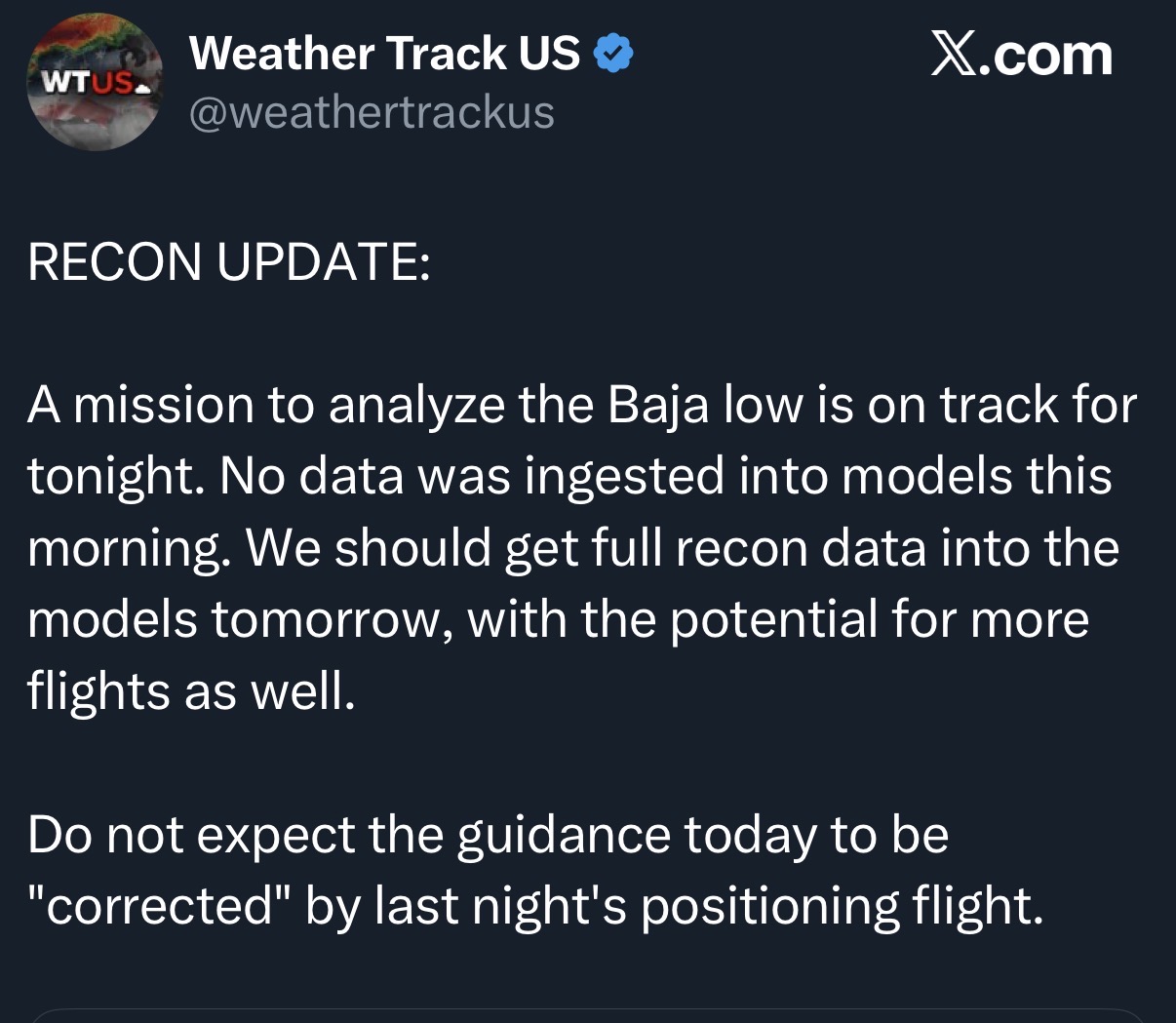
No recon data impacts in the models til tomorrow at the earliest. First data collecting flight is tonight.
-

Possible Record Breaking Cold + Snow Sunday 1/25 - Tuesday 1/27
eduggs replied to TriPol's topic in New York City Metro
The ECM and CMC show upper 20s at NYC late Sunday night. With flatter solutions a day ago, this was low 20s. -
noticed that as well. Also the northern stream is a little faster too which keeps the trough more positively tilted and you don't get time for a solid phase and a stronger primary. Personally I wouldn't mind a 'tad' more phasing. I don't mind smelling sleet and I'll even eat a little sleet if it results in a widespread hit for our sub.
-

Pittsburgh/Western PA WINTER ‘25/‘26
Burghblizz replied to Burghblizz's topic in Upstate New York/Pennsylvania
Cliff notes on new NWS AFD…. 50/50 shot at >10” in Pgh with higher probability south. -
I'm endorsing this 100%. I turn 68 on Monday. ALL IN!
-

Possible Record Breaking Cold + Snow Sunday 1/25 - Tuesday 1/27
SnoSki14 replied to TriPol's topic in New York City Metro
That would be the biggest storm in years. If you're complaining about that then find a new hobby -
Not sure if anyone mentioned but total qpf on euro did go down compared to 06z, back to 00z amounts. Dc lost .4