All Activity
- Past hour
-
Wonderful... I may need one soon
-
but further north like in new england it was snow; i think there was a roof collapse but i may be getting it confused with 2003, an almost as impressive storm, though in retrospect it was not as big. it was the second time in my life to see such a storm, bigger than anything in the 70s or 80s....and the storms we would go on to see....i'm getting too old to deal with megastorms anymore, but wouldn't mind a return to a 2014 or even 2021 scenario....
-
Off topic, but interested in buying a property in Thornton, NH. Anyone have any input on that area as far as how they feel about it and it’s proximity to the Whites and also snowfall and weather in general?
-
This winter sucks
-
Lame cop out. Who here has "denied" climate change is happening? Some of you think that if people aren't freaking out and claiming the world is ending due to climate change, they're deniers. It's not that binary, that's not reality.
-

January 2026 regional war/obs/disco thread
40/70 Benchmark replied to Baroclinic Zone's topic in New England
If you do really wan to push the "La Nina is dead" narrative, Feb 2013 maybe a higher end analog that is achievable.....I almost included it in my February list. -

2025-2026 ENSO
donsutherland1 replied to 40/70 Benchmark's topic in Weather Forecasting and Discussion
Several thoughts as we move deeper into January. La Niña is clearly waning. Region 3.4 has seen some recent warming. But La Niña is still having an influence. In a visible sign that there remains ocean-atmosphere coupling, the AAM is negative and forecast to remain negative for at least the next 7-10 days. As the La Niña wanes, its influence will also fluctuate. Fading weak La Niña events have mixed outcomes for February. This mixture of outcomes suggests that atmospheric patterns begin to carry greater weight as ENSO forcing weakens. By the end of the week, it will become clearer whether the PNA will move toward a regime change or a highly unusual brief PNA+ period followed by a resumption of a mainly negative PNA. By that time, the teleconnection guidance will be in its high-skill forecasting range. The base case remains a turn toward colder but not necessarily severely cold weather during the second half of January. The southern tier may still see only temporary intrusions of cold air. Snowfall prospects for the East Coast will depend heavily on the evolution of the PNA. In any case, at least through mid-month, significant snowfalls are unlikely for the East, as well as parts of the Great Lakes Region. -
The problem is that the complainers (Cassandras) usually end up being right. At least in recent years.
-

January 2026 regional war/obs/disco thread
mahk_webstah replied to Baroclinic Zone's topic in New England
Weather underground seems to be bumping the snow toes up a bit for tonight, but that might just be off of one model run or something -
I didn’t dig deeper into it. It just looked like a good set up. Meh. Whatevs. It will snow again one day…I think.
-

January 2026 regional war/obs/disco thread
WinterWolf replied to Baroclinic Zone's topic in New England
One can only hope. That was off the charts here. But we had a great look last Feb, and it shit the bed. Hoping this one can stay the course, and then deliver something? Too many decent looks with very little to show of late. But it’s nice to see. -
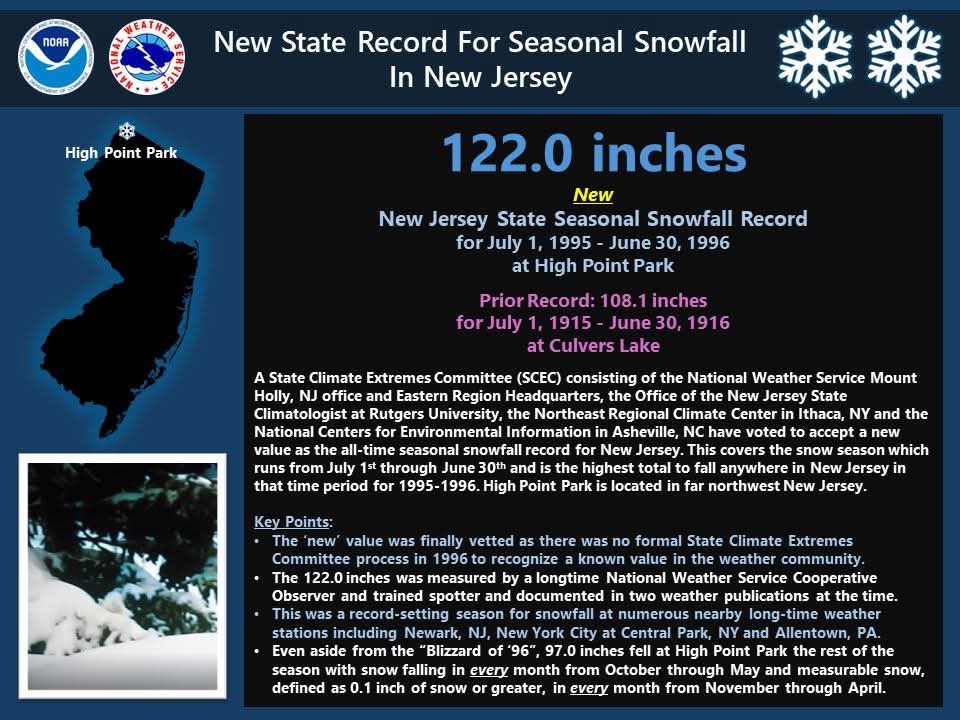
Interesting News from US National Weather Service Eastern Region HQ and NOAA National Centers for Environmental Information: As we remember the Blizzard of '96 which was 30 years ago this week, we also want to take a look back at the rest of the 1995-1996 snow season, of which the Blizzard of '96 was only a part of, especially in the I-95 corridor. This was for many at the time the snow season that would go down as the all-time snowiest ever, and in many cases, these records still hold 3 decades later. As part of the review process, we revisited the seasonal snowfall totals in many areas, and in some cases some data that was not part of the official dataset at the time was added within the last few months at some stations. Thus, this updates some records and as of today, the state seasonal snowfall record for any season for New Jersey is officially recognized as 122.0 inches at High Point Park for the 1995-1996 snow season. This is now considered the snowiest season on record at any station in New Jersey, breaking the prior record long held by the 1915-1916 snow season. To read the full report that explains why this was approved by the State Climate Extremes Committee for New Jersey, go to https://www.ncei.noaa.gov/monitoring-content/extremes/scec/reports/20260106-New-Jersey-Seasonal-Snowfall.pdf?fbclid=IwY2xjawPKM1JleHRuA2FlbQIxMABicmlkETFGUVg2clo5WlpDNUxPVGNSc3J0YwZhcHBfaWQQMjIyMDM5MTc4ODIwMDg5MgABHhOirwroeZZkBRsaF-pQR1x4KaequIFlPph93g7TC4Ojqyb7m6TSrgO-1Rx4_aem_hNtO9uFR3acAsgpjcquJ7Q
-
This came up in my memories from 2017 today: I am coming up for a visit in late Feb so brace yourselves for a torch lol.
-
Yes
-
I remember the 1/12/96 storm started as 5 minutes of snow then all rain, then big warmup and melt. But of course by Feb it came back and even into April we had significant snow events.
-
-

E PA/NJ/DE Winter 2025-26 Obs/Discussion
Newman replied to LVblizzard's topic in Philadelphia Region
Well obviously the Jan 7-10th period isn't going to work out and we've regressed back to maybe around the 1/13-1/17 period or so for winter weather prospects returning. However, ensembles aren't too keen on any real help in the NAO department. So although we have a more favorable EPO/Pacific regime, which will help to bring the cold back, we might see a lot of waves zip down the ridge out west and slide quickly through the Mid-Atlantic. With no -NAO, there won't be opportunity for any 50/50 lows to settle into place. So yes there could definitely be snow in mid-January (as long as we don't regress any more), though I don't see any big wound up coastal storm chances outside of a rogue double/triple phaser if the northern and southern streams cooperate, though chances of that are slim with the faster flow. Perhaps a faster flow advisory or low-end warning type event. The 12z Euro for 1/15 looks close on the h500 maps with some phasing going on, though in reality there's the kicker system on its heels pushing everything quickly east so the trough can't turn negative. We're still 9 days out though so a lot will change from now to then -
January 2026 regional war/obs/disco thread
WinterWolf replied to Baroclinic Zone's topic in New England
It was I who brought up 2015, in response to TBlizz whining. And yes, the season was still huge here. The only point was we weren’t even close to any JP in any of those storms…WOR. We’d get 7-9”, and out east would double it and more, every storm that period. So that was the point. We had a decent March in 15 though that brought us up some once the big blitz was over. So that’s that. It was impressive for sure…but it was nothing like EOR, and SEMASS. And my point was, I’d much rather miss out on an 8” storm and get 3-4”, then miss on a 24-30” storm and get 7-8”. Cuz that’s what WOR did in 2015. -
Let me see if I got this right. You'd be complaining about a complainer that's complaining about the complainers complaining about the original complainers?
-
How? It's a passage of a cold front after a period of decently AN temps that are slow to leave. Very little precip falls per the run before and after that 216hrs panel.
-
lol
-
The average new EV sold in the USA today in 20% more expensive than the average new petroleum powered vehicle. EVs in the US are still mostly sold to the higher end / luxury market, the number of vehicle models available at the lower end of the market is extremely limited (but increasing). And I agree that in the higher end and luxury class vehicles, EVs equal or exceed petroleum powered vehicles in all aspects but one, and that is refueling convenience, which is arguable, since arguably it is more convenient to refuel your vehicle overnight in your garage or driveway than it is to dedicate a trip to a petroleum dispensing facility. As soon as Honda or Toyota makes an Accord or Camry EV that is on par in price and weight to the petroleum versions, I'll be going for a test drive. Battery tech is advancing rapidly and it won't be much longer before EVs have a much greater presence in the USA.
-
You are correct, a nice deep snowpack completely wiped out all over the northeast on 1/19-1/20/96. https://pubs.usgs.gov/publication/wri974252
-

Winter 2025-26 Medium/Long Range Discussion
A-L-E-K replied to michsnowfreak's topic in Lakes/Ohio Valley
-
We have seen system after system fail to produce the modeled rainfall this Fall and Winter so far. Some, like the last one, just completely dried up as it got to us. This one feels and looks different though, so hopefully it’s the beginning of a change for us. As has been said, La Nina can be tough for our area to get precip at times, and I think that’s what we’ve been seeing. It looks like the Nina has met its demise now though, Hopefully!


