All Activity
- Past hour
-
Just upgraded to 5% .
-
That’s a lot of water to our west on Albany radar. Bring it!
-

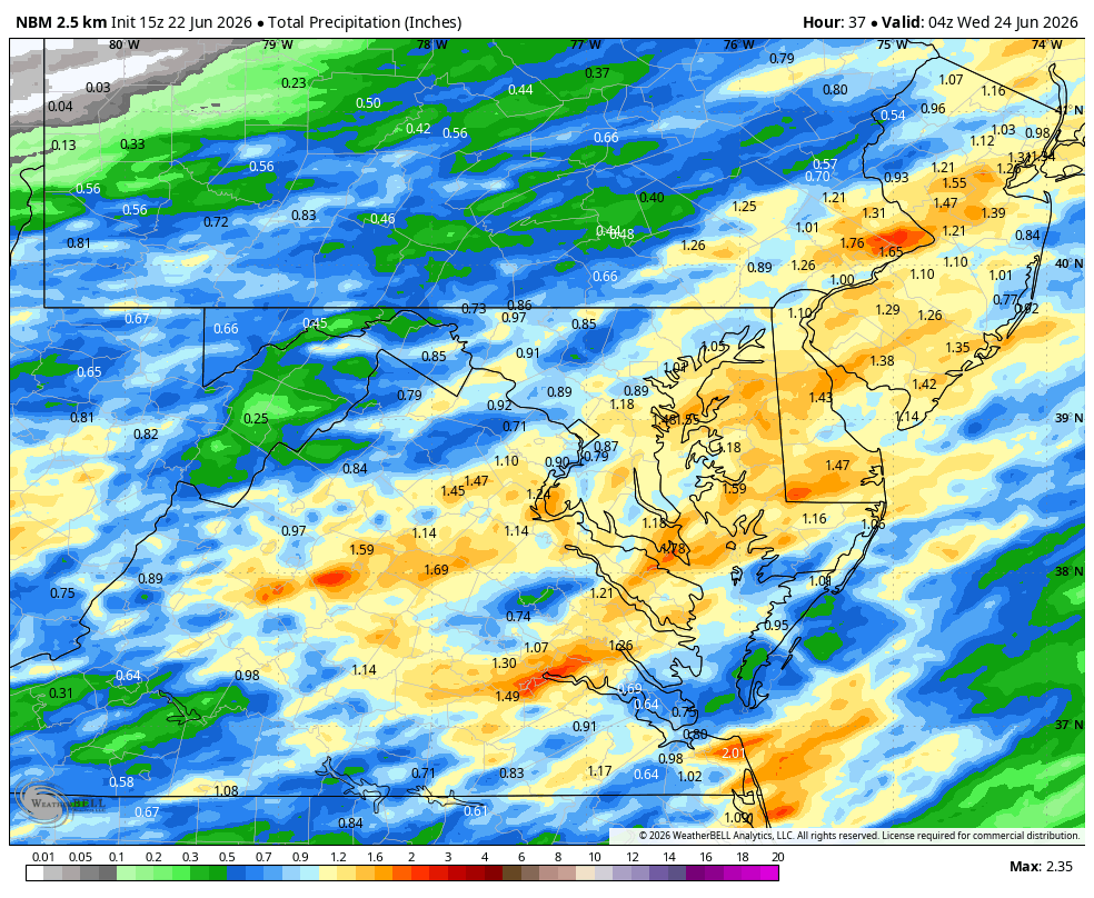
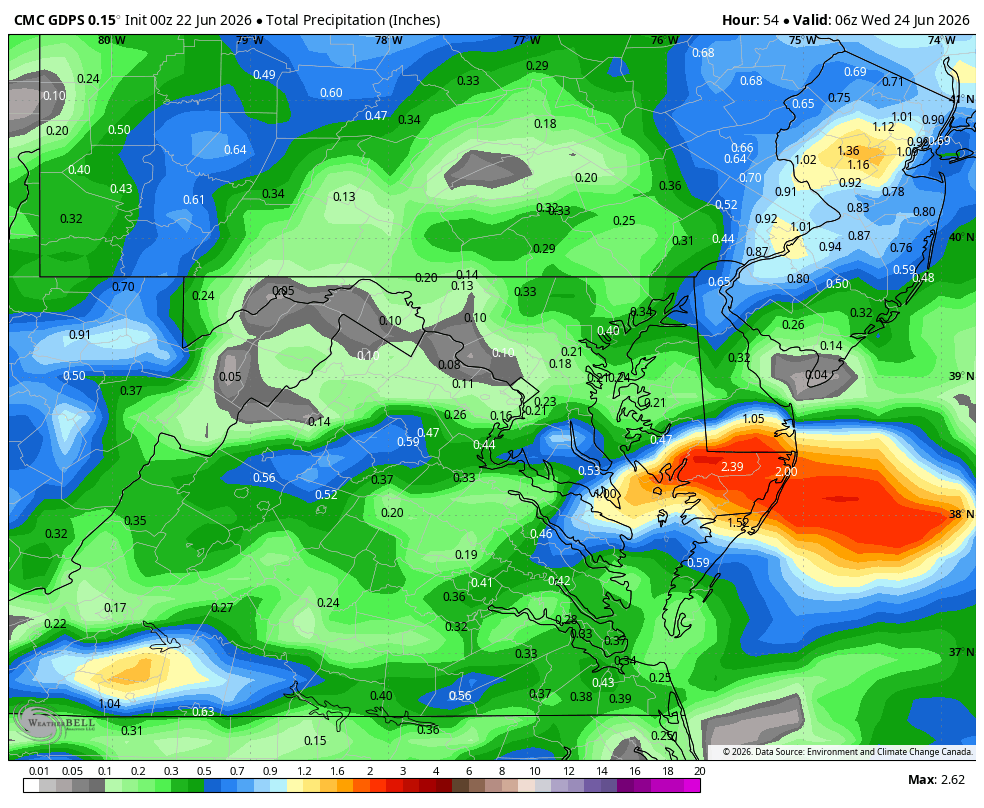
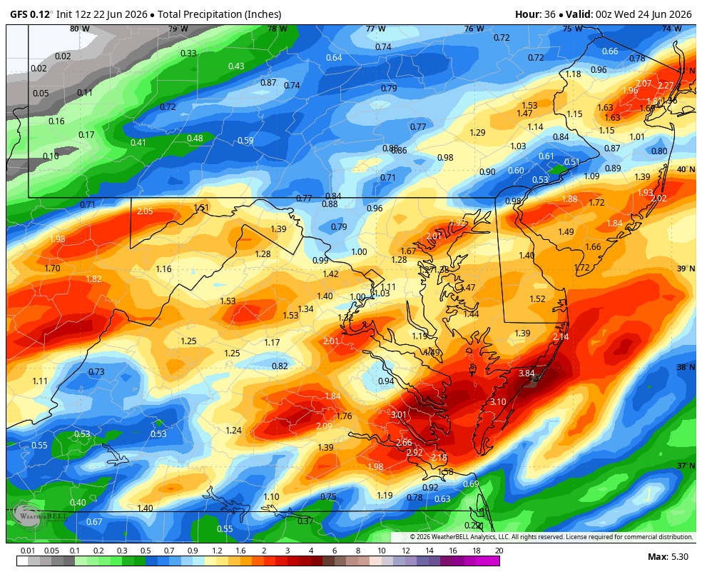
Wet late Monday 6/22 or another Fizzle?
Weather Will replied to Weather Will's topic in Mid Atlantic
WB 15Z NBM through Tuesday would be nice .75 to inch for most of us.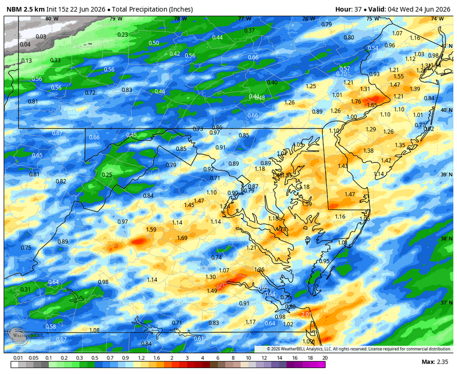
-
Pouring in Brightwaters unfortunately that’s probably the only rain that I, and most of the island will see
-
Given this (granted its early) I don't think tropical is anything we'll be tracking. Unless you want to count any remnant Gulf systems being absorbed in troughs come Fall and moving up to our west
-
The 12z CSU MLP update re-increased the 5% area for TOR and also inched the 30% wind closer to MBY.
-
Good luck counting on that day. Not much will happen tomorrow
-
HRR is putting the heavy axis of QPF in SNH and SVT. What are everyones thoughts on this? 3" max or more?
-
91F at DCA.
-
Can we actually back into a nice event??
-
Actually looks decent for two convective chances tomorrow morning, then later in the afternoon/evening. Would be tough to go 0-3 with one system, but Stein still has his fastball
-
Wet late Monday 6/22 or another Fizzle?
Weather Will replied to Weather Will's topic in Mid Atlantic
WB 12Z Can. Is also onboard for tomorrow. Much wetter than 0Z.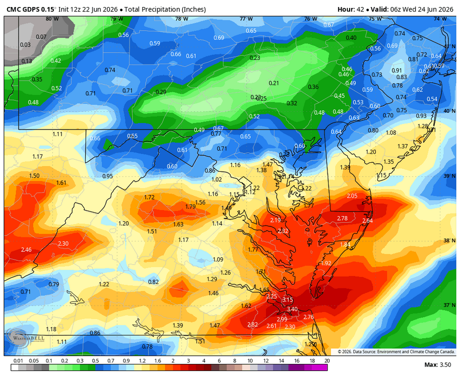
-
Looks like about a buck 50 on the NAM N of the Pike. Nothing ridic. Beneficial. ...I'm sure we'll focus on whatever 5.76" version instead... but probably this is a 'standard' soaking
-
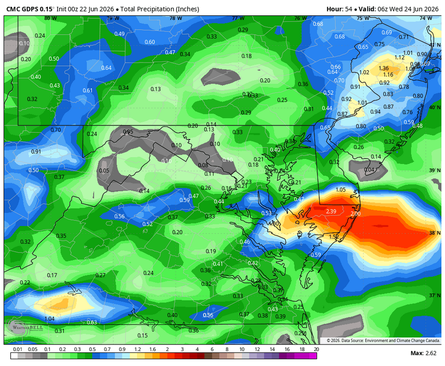
Wet late Monday 6/22 or another Fizzle?
Weather Will replied to Weather Will's topic in Mid Atlantic
WB 12Z GFS through Tuesday.
-
Dew point was in the mid 30's this morning. Not something you normally see in this part of Michigan in the latter part of June.
-
I’d be surprised if I get more than half an inch
-
We are back to the sudden move north again for systems. All the steady rain well north of where it was modeled a few days ago.
-
How does this current pattern affect any potential tropical activity up here? If it does at all?
-
So much for the cool and rainy El Nino summer. Looks like our drought could get even worse. This was at Falls Lake yesterday (main sections still have water but even that is looking quite shallow in places):
-

2026-2027 Super El Nino
GaWx replied to Stormchaserchuck1's topic in Weather Forecasting and Discussion
Interestingly, since that WCS tweet was made on 5/28/26 showing the then latest WCS PDO (5/27/26) down at -1.40, then near a 6 month low, the WCS PDO has risen nearly 1 in just 25 days while El Niño has gotten much stronger to -0.48: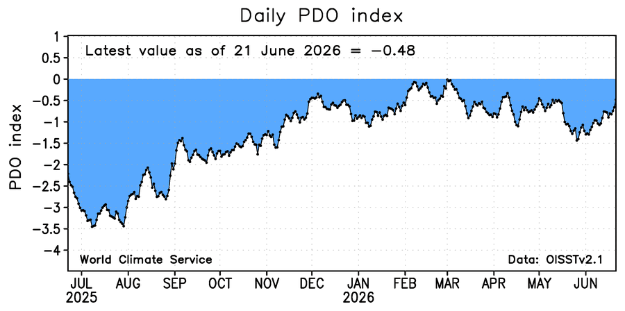
-
yeah most of today now looks dry. Delayed not denied LOL!
-
This will yet again be a <0.10" event, maybe even nothing here.
-
B But they're not even in a drought!!! /s
-
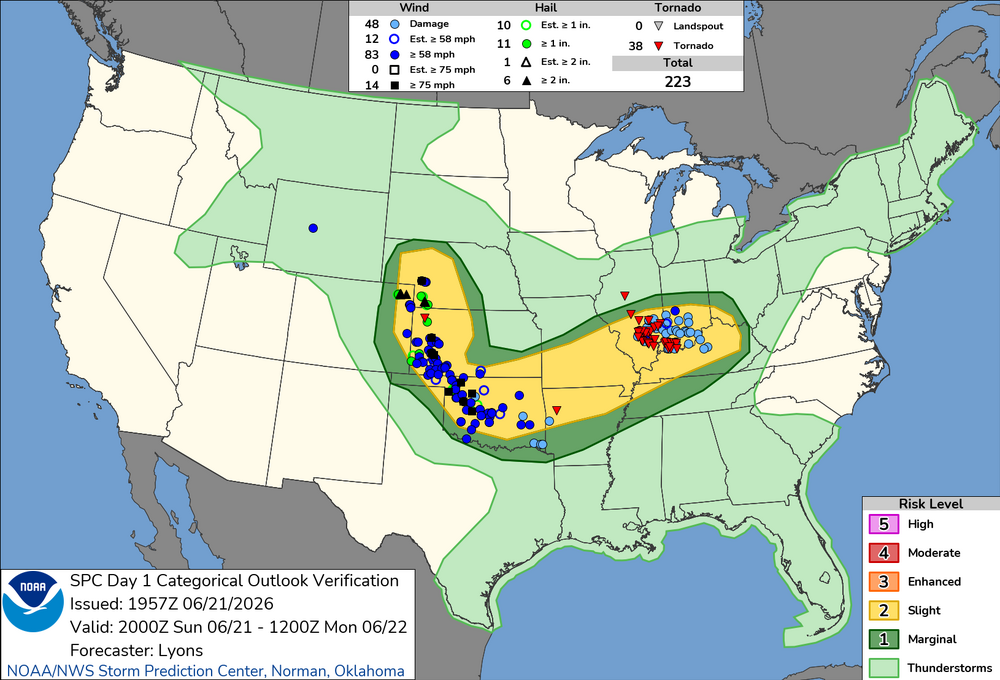
What a day.. I'm surprised they didn't go with moderate at some point. Even at 20z it was obvious something was up. Evansville fire and EMA were talking on the radio about watching Ryan Hall trying to figure out where the tornado was.
- Today
-
Ladies and gentleman, the broiler is about to be turned on.


.thumb.jpeg.f5c6ba9d911ec96b3b124f8606aee58e.jpeg)


